The 20 April 2023 Total Solar Eclipse in Australia
UPDATE 20 May 2023 : this eclipse has already occurred so check out the pages for the 2028, 2030, 2037 or 2038 eclipses instead.
The most recent pre-eclipse version of this page is shown below for historical interest, but it will not be updated.
Time remaining until total eclipse begins on centre line near Exmouth: --d --h --m --s
Weather forecasts for Exmouth and zoomable high resolution satellite images.
Cloud forecasts for this eclipse from Cloud Free Night and Skippy Sky.
Skip to:
Plans and facilities for eclipse visitors.
Exmouth and region total eclipse details and maps.
Barrow Island and Montebello Islands total eclipse details and maps.
Eclipse times along the eclipse centre line.
The sky during total eclipse.
The partial eclipse at other places in Australia.
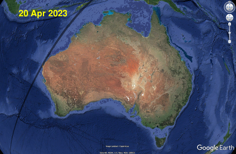
This eclipse begins its path near the remote Kerguelen Islands, as a broken-ring / beaded-ring annular eclipse at local sunrise. Just after touching down on Earth it becomes a total eclipse, whose path continues to slowly widen as it crosses the southeastern Indian Ocean. Its first landfall is on the North West Cape peninsula in Western Australia, in the late morning (local time). By now its path is about 40km wide and the total eclipse duration along its centre line is about 1 minute. It continues as a total eclipse across Barrow Island, the Montebello Islands and a few other islands and reefs (including Ashmore Reef), before leaving Australian territorial waters. It then crosses Timor Leste (where the maximum total eclipse duration of 76 seconds occurs), continues across western New Guinea, then into the western Pacific Ocean where it transitions back into an annular solar eclipse near local sunset, just before it leaves the Earth's surface.
This page includes maps and lists of eclipse times for many Australian locations below.
Eclipse viewing in Australia on 20 April 2023
Locations that see this total eclipse will also see over an hour of partial solar eclipse before and after. Outside of the total eclipse path the rest of Australia will see a partial solar eclipse. You will need ISO 12312-2 certified eye protection, or indirect viewing methods, to safely view the partial eclipse -- read our eclipse eye safety notes.The North West Cape peninsula hosts various military facilities and the Learmonth Solar Observatory (all closed to the public). It also contains the rugged Cape Range National Park, Jurabi Coastal Park, and other nature reserves -- all part of the World Heritage-listed Ningaloo Coast. The spectacular fringing coral reefs and marine life of the Ningaloo Marine Park are, in many places, within swimming distance of the local beaches. Bring your facemask and snorkel. Or join a boat tour to swim with the Whale Sharks.
Exmouth is the only significant Australian town within the path of totality. The nearby Learmonth airport is also inside totality and has scheduled airline flights to & from Perth.
If you're driving to Exmouth be aware that it's hundreds of kilometres by road from the nearest other significant towns. Its connection to the rest of Australia is via single lane bitumen roads, traversing long distances through mostly uninhabited landscapes. STAY WITH YOUR VEHICLE if it breaks down between towns, so that rescuers can find you more easily.
If you're not part of an organised tour group, or staying somewhere that offers full catering, then it's strongly recommended that you bring your own food and water (and camping supplies) sufficient for several days.
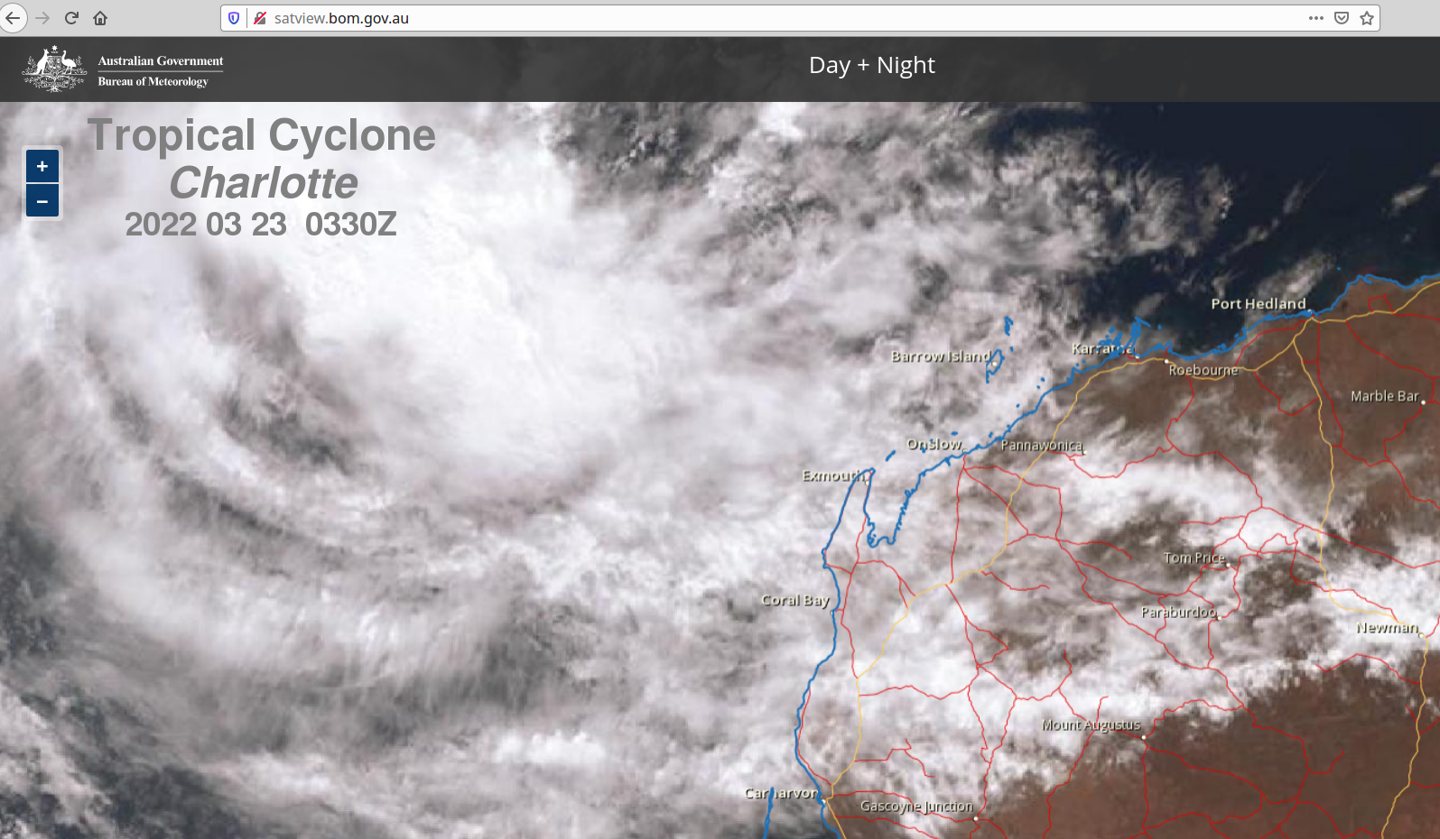
This part of Australia's coastline occasionally gets tropical cyclones, although April is normally the end of cyclone season and late April is usually sunny and warm. The ocean to the northeast of Exmouth also shares this sunny April climate. Of course a cyclone might still cover Exmouth in clouds even if it's far offshore -- for example Tropical Cyclone Charlotte in March 2022. But as tens of thousands of people discovered in northern Queensland on 14 November 2012, a total eclipse playing peek-a-boo between clouds is still exciting to watch.
Weather radars and weather forecast maps are available from here, and high-resolution weather satellite images are here. There's also the daily weather forecast for Exmouth. Long term climate information is available for Learmonth airport.
Plans and facilities for eclipse visitors
TRAVEL UPDATE (15 April 2023): Tropical Cyclone Ilsa crossed the Pilbara region's coastline between Port Hedland and Broome on the night of 13-14 April. Port Hedland and Broome both escaped damage, but the Pardoo Roadhouse was hit by the cyclone's 250+ km/h central winds and got wrecked. Many roads from the Pilbara coast to inland communities and mine sites are now flooded and not expected to fully re-open for weeks.Cyclone-related flash flooding in the Pilbara region is not unusual, but it's in addition to the flood damage earlier this year in the Kimberley region.
Record-breaking floods began in the Kimberly region (in the north of Western Australia) in early January 2023, caused by huge rainfalls from ex-Tropical Cyclone Ellie. This flooding caused widespread and massive damage to roads and infrastructure, some of which has not been repaired yet:
- You can drive from Perth to Exmouth, and then further north past Onslow and through the Pilbara region to Port Hedland along the main road (Great Northern Highway).
- The Great Northern Highway between Port Hedland and Broome sustained additional flood damage from Cyclone Ilsa and there's still water over the road in several places. These floodwaters may conceal new potholes or wash-outs, so drive carefully. Floodwaters along the Highway are expected to subside during the next few days.
- You can also drive from the Northern Territory westwards into Kununurra, Halls Creek and Lake Argyle provided you stay on the sealed roads. Many of the unsealed roads near the WA-NT border, including the Tanami Track and the Gibb River Road, are still closed due to flooding.
- The main road (Great Northern Highway) at Fitzroy Crossing is still closed to through traffic. The road bridge over the Fitzroy River collapsed during the January floods and needs to be totally rebuilt.
- A temporary crossing using cable barges/ferries is being established, followed by a temporary road crossing to be built across the Fitzroy River bed during this year's Dry Season (from May 2023). The barges will have limited capacity and priority will probably be given to local residents + essential supplies. Expect a queue.
- Some intervals of main road between Broome and Fitzroy Crossing were also destroyed; but have re-opened after temporary repairs. Speed restrictions are in place.
- The main road from Broome to Derby has reopened after temporary repairs.
- Almost every unsealed road in the Kimberly region is still closed (sometimes unofficially) and will probably remain closed to tourists until mid-2023. Many of these roads are still impassable to any wheeled land vehicle.
For the latest main road closures and restrictions, see the Western Australia Main Roads travel map.
(original notes below)
Local planning for this eclipse was delayed by the Western Australian government's prolonged COVID-19 border closures and travel restrictions. So the WA government's official 2023 eclipse website still contains information gaps. And apparently was written (and approved) by someone who's never actually seen a total solar eclipse. Which hopefully may all get fixed before April 2023.
Unfortunately it also still promotes outdated and misleading Eclipse Eye Safety information. In fact A TOTALLY ECLIPSED SUN is safe to view directly. You only need ISO 12312-2 certified eye protection, or indirect viewing methods, to view the sun when it's NOT TOTALLY ECLIPSED. Read our eclipse eye safety notes.
The Exmouth visitor centre is your best source for local tourism information. And they have a fascinating aquarium and historical display too. Exmouth is part of a larger tourism region known as the Coral Coast, so if you're planning a longer visit, check out the Coral Coast eclipse website for lots of things to see and do.
All existing tourist and visitor accommodation in the Exmouth region is already booked out and all Learmonth airport rental vehicles are booked out. You may still get lucky if someone else cancels their eclipse trip; but expect to be paying $$$. Overnight camping outside of officially designated camp grounds is already strongly discouraged by the local government (and the National Park's rangers), and may result in you being fined. There are plans to temporarily increase camping and local transport capacity in Exmouth for the eclipse. Contact the Exmouth visitor centre for details.
Some commercial tour operators have pre-booked local accommodation and other facilities for their own eclipse tours. Places might still be available on some tours (do a search for April 2023 solar eclipse tours). P&O Cruises are sailing a cruise ship to this eclipse from Fremantle.
The town of Onslow is also preparing for this event, which for them will be a 99.4% partial eclipse climaxing at 11:32:31 (local time). Local fishing / diving charter operators may be offering boat trips from Onslow into the total eclipse path. The southern limit of total eclipse passes about 24 kilometres northwest of Onslow. The eclipse centre line is about 47 kilometres northwest of Onslow. Onslow will also be the first town in Australia to see the 26 December 2038 total solar eclipse.
Exmouth and region (and other places in/near total eclipse)
The longest duration for this total eclipse on the Australian mainland is 60.5 seconds, on the coastline between Learmonth and Exmouth. At mid-totality the eclipsed Sun will be just over 54 degrees above the horizon at an azimuth of 22 degrees (north-northeast). The longest duration for any Australian land location is 65.9 seconds, occurring on the southeast corner of East Island in the remote Ashmore Reef territory. In Australian territorial waters near Ashmore Reef the duration on the eclipse centre line is 73.5 seconds. Coral Expeditions will be cruising here to see the eclipse.
Many websites wrongly claim this eclipse will be 76 seconds long at Exmouth.
Yes this event does have a maximum total eclipse duration of 76 seconds,
but it's happening in Timor Leste, about 1900km northeast of Exmouth!
Yes this event does have a maximum total eclipse duration of 76 seconds,
but it's happening in Timor Leste, about 1900km northeast of Exmouth!
The North West Cape peninsula features a main road along each coast. The Minilya-Exmouth Road along the east coast links the peninsula to the rest of Western Australia. It is a single lane bitumen road passing through Learmonth and Exmouth (where it name-changes to Murat Road) to a dead-end by the eastern side of the huge radio masts at the Naval Communications Station Harold E Holt. The Communications Station occupies the northern tip of the North West Cape peninsula and it is closed to the public. Shortly before the end of Murat Road, a T-junction marks the beginning of Yardie Creek Road which follows the Communication Station's southern boundary to the Vlamingh Head Lighthouse turnoff (Johnson Road).
From the turnoff the (mostly) unsealed west coast main road, still called Yardie Creek Road, continues into the Cape Range National Park past numerous caravan/tent campgrounds to end at the Yardie Creek campground.
On the south side of Yardie Creek a four-wheel-drive track continues down the peninsula's west coast to the Ningaloo Station homestead. There is no bridge over Yardie Creek to connect the two road sections; travelling from one to the other requires driving along the beach here.
Between these two coastal roads the interior of the peninsula is traversed by unsealed public roads going to various scenic locations, by national park maintenance & firefighting tracks, and by access roads to various military installations.
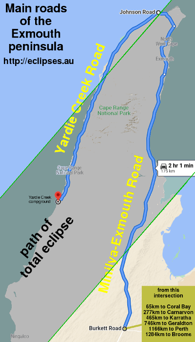
The two coastal roads and their immediate vicinities are likely to be the viewing venues for most eclipse visitors. So we've drawn graphs of driving distances -vs- total eclipse durations (corrected for the actual lunar topography) for both roads.
Click the graphs for a larger image (in new window).

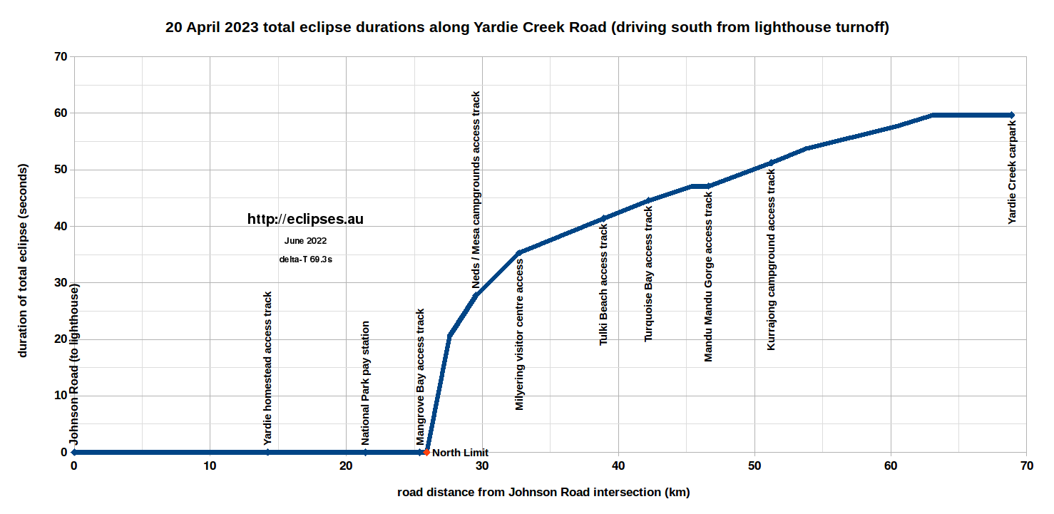
As the first graph shows, there's about twenty kilometres of the east coast main road where the total eclipse duration will be indistinguishable from centre line.
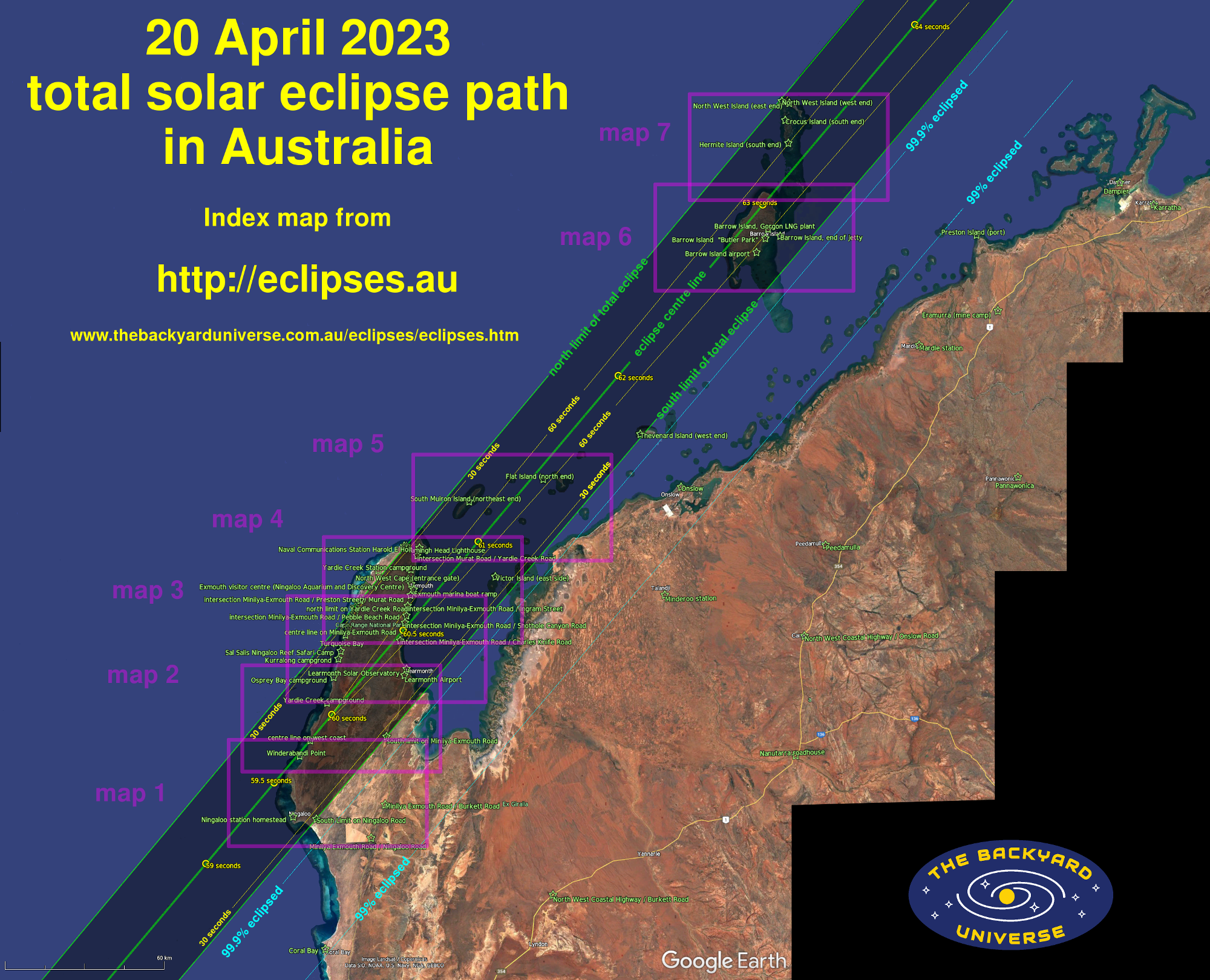
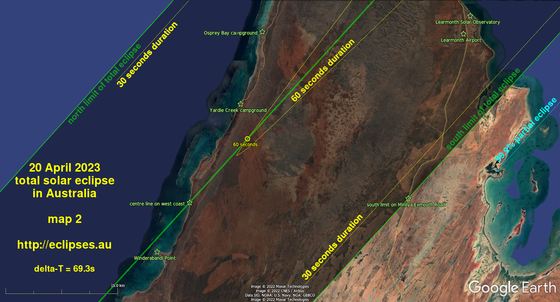
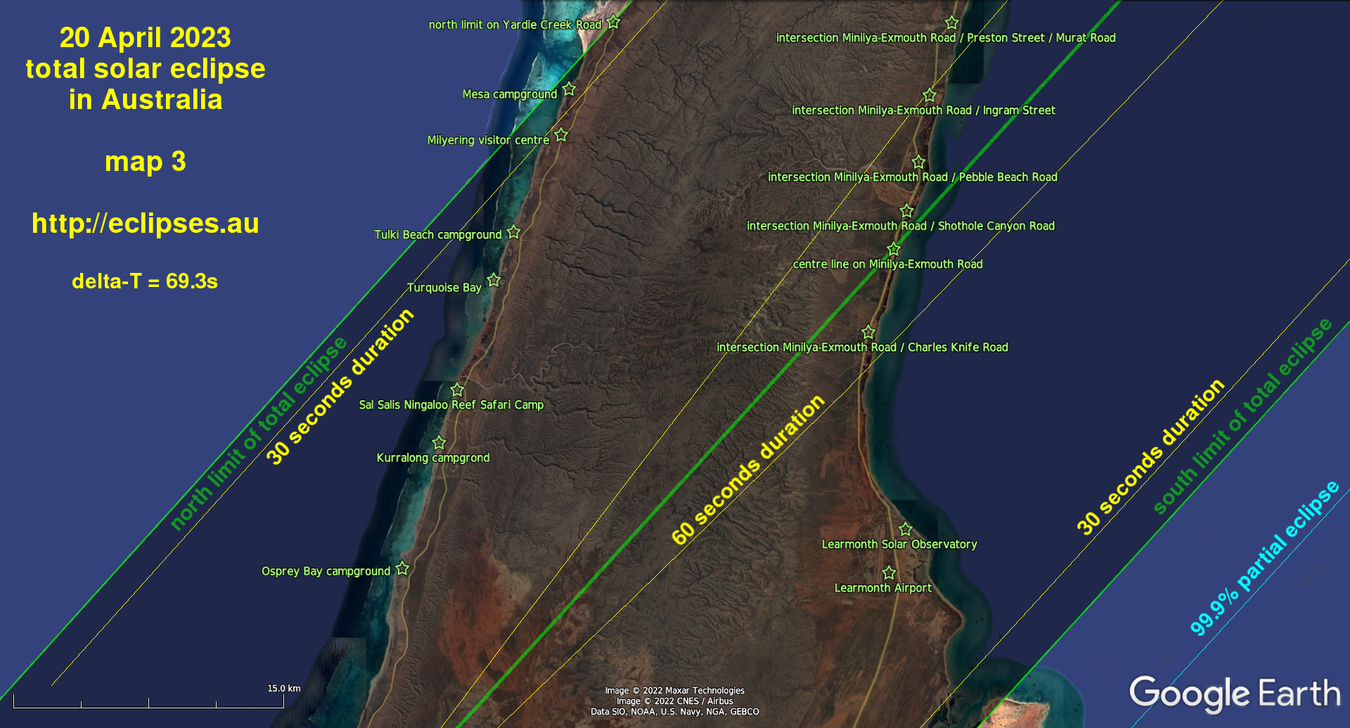
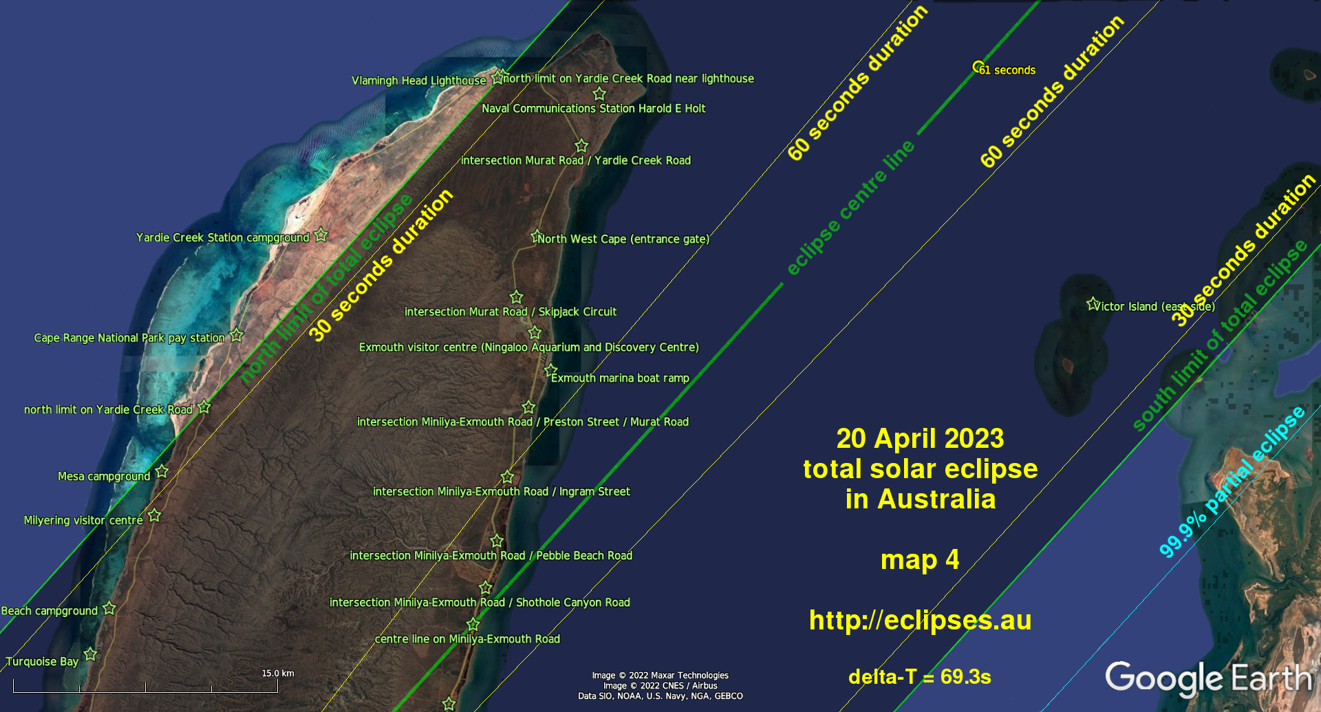
Eclipse maps
What do all these lines and symbols on the maps mean?- The maps were built from Google Earth images. To reduce the clutter we've converted the ocean to a blue colour, but leaving most of the reefs and shoals unchanged. Also unchanged are the land areas -- yes, this part of Western Australia really is that red...
- The wide darker-shaded strip is the path of the total eclipse. If you are outside this strip you will not see a total eclipse on 20 April 2023, and you will also not see the most spectacular phenomena that are only visible during a total eclipse.
The bright green lines along the strip are the eclipse's centre line, north limit and south limit. - The yellow contours inside the path of total eclipse indicate 30 seconds and 60 seconds of total eclipse duration.
- The yellow circles along the eclipse centre line mark seconds of total eclipse duration. The duration increases as you get closer to Timor Leste.
- The light blue lines outside of the path of total eclipse indicate the percentage of the Sun's visible surface (a.k.a. Eclipse Obscuration) that is covered by a partial eclipse. For a 99% partial eclipse the Sun will shrink to a very thin crescent, the location will get noticeably cooler, and shadows at maximum eclipse will appear unusually "sharp". For a 99.9% partial eclipse the Sun will shrink even more to a disconnected crescent of dazzling arcs and beads. For this eclipse, the distance from 99.9% partial to a total eclipse experience is less than 10km.
- The green stars and labels mark locations listed in the Eclipse times below.
All of the maps and timings have been corrected for the actual lunar topography, and for the latest Delta-T prediction (69.3s). For this eclipse while it's crossing the North West Cape peninsula, the actual South Limit of the total eclipse path will differ by about 50 metres from the geometrically-smooth-moon calculation. This difference can be ignored by eclipse tourists. But the actual North Limit of the total eclipse path will be displaced about 1400 metres inside the geometrically-smooth-moon calculation!
Click the maps for a larger image (in new window).


Eclipse times
All event times for total and nearly-total eclipses have been corrected for the moon's actual topography. Nearly all of the peninsula and islands within the eclipse path are less than 250 metres above sea level. And the Sun will be high in the northern sky at the time of the eclipse. Consequently we haven't included any (tiny) corrections due to topographic elevation and atmospheric refraction.- The first table lists locations in the Exmouth region within the total eclipse path, followed by locations that almost get a total eclipse. All of these places are shown on the maps above.
- The second table is for Barrow Island and the Montebello Islands. All of these islands get a total eclipse, and are shown on the maps above.
- The third table lists points along the eclipse centre line. Most of these will require a boat capable of offshore sailing; such as the fishing/diving charter boats operating from Exmouth, Onslow or Broome.
- The fourth table is for selected locations in the rest of Australia.
|
(Scroll sideways if you're viewing this on a small screen) |
|||||
| Location | Western Australia local time (UT +8h) HH:MM:SS | ||||
| partial eclipse begins | total eclipse begins | total eclipse ends | total eclipse duration | partial eclipse ends | |
| eclipse centre line on Minilya-Exmouth Road Lat 22.0838° S long 114.0968° E | 10:04:20 | 11:29:29.6 | 11:30:30.1 | 60.5 seconds | 13:02:13 |
| eclipse centre line on the peninsula's west coast lat 22.4378° S long 113.7482° E | 10:03:30 | 11:28:21.4 | 11:29:21.2 | 59.8 seconds | 13:00:51 |
| eclipse North Limit on Yardie Creek Road near Mangrove Bay lat 21.9740° S long 113.9505° E | 10:04:16 | 11:29:54.9 | 11:29:54.9 | zero seconds | 13:02:07 |
| eclipse North Limit on Yardie Creek Road near Vlamingh Head Lighthouse lat 21.8072° S long 114.1132° E | 10:04:40 | 11:30:27.3 | 11:30:27.3 | zero seconds | 13:02:46 |
| eclipse South Limit on Minilya-Exmouth Road lat 22.4329° S long 114.0248° E | 10:03:51 | 11:29:21.4 | 11:29:21.4 | zero seconds | 13:01:25 |
| eclipse South Limit on Ningaloo Road lat 22.7071° S long 113.7521° E | 10:03:12 | 11:28:28.4 | 11:28:28.4 | zero seconds | 13:00:21 |
| Ashmore Reef (southeast corner of East Island) | 10:32:06 | 12:04:51.7 | 12:05:57.6 | 65.9 seconds | 13:41:03 |
| Exmouth marina boat ramp (near south end of Exmouth) | 10:04:31 | 11:29:47.6 | 11:30:46.2 | 58.6 seconds | 13:02:32 |
| Exmouth visitor centre (Ningaloo Aquarium and Discovery Centre) | 10:04:32 | 11:29:49.6 | 11:30:44.7 | 55.1 seconds | 13:02:34 |
| Flat Island (north end) | 10:05:33 | 11:31:08.8 | 11:32:09.7 | 60.9 seconds | 13:04:12 |
| intersection Minilya-Exmouth Road + Charles Knife Road | 10:04:16 | 11:29:24.3 | 11:30:24.6 | 60.3 seconds | 13:02:07 |
| intersection Minilya-Exmouth Road + Ingram Street | 10:04:26 | 11:29:39.5 | 11:30:39.7 | 60.2 seconds | 13:02:24 |
| intersection Minilya-Exmouth Road + Pebble Beach Road | 10:04:23 | 11:29:35.4 | 11:30:35.7 | 60.4 seconds | 13:02:19 |
| intersection Minilya-Exmouth Road + Preston Street + Murat Road | 10:04:29 | 11:29:44.4 | 11:30:43.5 | 59.1 seconds | 13:02:29 |
| intersection Minilya-Exmouth Road + Shothole Canyon Road | 10:04:21 | 11:29:32.2 | 11:30:32.6 | 60.5 seconds | 13:02:16 |
| intersection Murat Road + Skipjack Circuit (north end of Exmouth) | 10:04:33 | 11:29:51.5 | 11:30:42.9 | 51.4 seconds | 13:02:34 |
| intersection Murat Road + Yardie Creek Road | 10:04:41 | 11:30:04.5 | 11:30:50.0 | 45.5 seconds | 13:02:47 |
| Learmonth Airport (carpark) | 10:04:09 | 11:29:18.2 | 11:30:11.6 | 53.3 seconds | 13:01:55 |
| Learmonth Solar Observatory | 10:04:11 | 11:29:20.3 | 11:30:15.5 | 55.2 seconds | 13:01:58 |
| Kurralong campground | 10:03:55 | 11:29:01.0 | 11:29:50.9 | 49.9 seconds | 13:01:33 |
| Mesa campground | 10:04:12 | 11:29:36.4 | 11:29:55.2 | 18.8 seconds | 13:02:01 |
| Milyering visitor centre | 10:04:10 | 11:29:29.0 | 11:30:03.6 | 34.6 seconds | 13:01:58 |
| Naval Communications Station Harold E Holt (centre tower of the array) | 10:04:43 | 11:30:09.7 | 11:30:52.1 | 42.9 seconds | 13:02:51 |
| Ningaloo station homestead | 10:03:07 | 11:27:56.2 | 11:28:43.3 | 47.1 seconds | 13:00:13 |
| North West Cape (entrance gate) | 10:04:36 | 11:29:56.5 | 11:30:45.2 | 48.7 seconds | 13:02:39 |
| Osprey Bay campground | 10:03:50 | 11:28:51.8 | 11:29:46.9 | 55.1 seconds | 13:01:24 |
| Sal Salis Ningaloo Reef Safari Camp | 10:03:58 | 11:29:05.2 | 11:29:52.8 | 47.6 seconds | 13:01:37 |
| South Muiron Island (northeast end) | 10:05:08 | 11:30:40.8 | 11:31:29.1 | 48.3 seconds | 13:03:32 |
| Thevenard Island (west end) | 10:06:10 | 11:32:17.1 | 11:32:35.2 | 18.1 seconds | 13:05:11 |
| Tulki Beach campground | 10:04:05 | 11:29:18.7 | 11:29:58.8 | 40.1 seconds | 13:01:49 |
| Turquoise Bay (car park) | 10:04:03 | 11:29:14.4 | 11:29:56.7 | 42.3 seconds | 13:01:46 |
| Victor Island (east side) | 10:04:56 | 11:30:24.9 | 11:31:14.1 | 49.2 seconds | 13:03:12 |
| Winderabandi Point | 10:03:23 | 11:28:11.6 | 11:29:11.3 | 59.7 seconds | 13:00:39 |
| Yardie Creek Carpark (south end of Yardie Creek Road) | 10:03:42 | 11:28:39.5 | 11:29:39.2 | 59.7 seconds | 13:01:11 |
| Cape Range National Park pay station (on Yardie Creek Road) | 10:04:20 | NEARLY total, maximum obscuration 99.998% at 11:30:00 | 13:02:13 | ||
| Vlamingh Head Lighthouse | 10:04:39 | NEARLY total, maximum obscuration 99.9997% at 11:30:27 (North Limit is about 130 metres southeast of here) | 13:02:45 | ||
| Yardie Creek station campground | 10:04:27 | NEARLY total, maximum obscuration 99.996% at 11:30:07 | 13:02:25 | ||
| Carnarvon | 10:00:56 | NOT total, maximum obscuration 94.7% at 11:25:15 | 12:56:09 | ||
| Coral Bay | 10:02:46 | NOT total, maximum obscuration 99.04% at 11:27:52 | 12:59:35 | ||
| Dampier | 10:09:28 | NOT total, maximum obscuration 97.7% at 11:36:59 | 13:10:19 | ||
| Eramurra (mine camp) | 10:08:22 | NOT total, maximum obscuration 97.8% at 11:35:28 | 13:08:33 | ||
| intersection Minilya Exmouth Road + Burkett Road (near Bullara Station homestead) | 10:03:34 | NOT total, maximum obscuration 99.62% at 11:28:59 | 13:00:57 | ||
| intersection Minilya Exmouth Road + Ningaloo Road | 10:03:22 | NOT total, maximum obscuration 99.50% at 11:28:43 | 13:00:38 | ||
| intersection North West Coastal Highway (1) + Burkett Road (turnoff to Exmouth if approaching from the Pilbara) | 10:03:59 | NOT total, maximum obscuration 97.3% at 11:29:33 | 13:01:31 | ||
| intersection North West Coastal Highway (1) + Onslow Road | 10:06:08 | NOT total, maximum obscuration 97.0% at 11:32:29 | 13:05:01 | ||
| Karratha | 10:09:33 | NOT total, maximum obscuration 97.2% at 11:37:05 | 13:10:23 | ||
| Mardie station homestead | 10:07:50 | NOT total, maximum obscuration 98.3% at 11:34:47 | 13:07:46 | ||
| Minderoo station homestead | 10:05:38 | NOT total, maximum obscuration 98.7% at 11:31:49 | 13:04:18 | ||
| Nanutarra roadhouse | 10:05:39 | NOT total, maximum obscuration 96.1% at 11:31:48 | 13:04:09 | ||
| Onslow | 10:06:09 | NOT total, maximum obscuration 99.41% at 11:32:31 | 13:05:09 | ||
| Pannawonica | 10:07:47 | NOT total, maximum obscuration 96.2% at 11:34:42 | 13:07:34 | ||
| Peedamulla | 10:06:36 | NOT total, maximum obscuration 97.6% at 11:33:07 | 13:05:46 | ||
| Preston Island (port) | 10:08:33 | NOT total, maximum obscuration 98.7% at 11:35:45 | 13:08:55 | ||
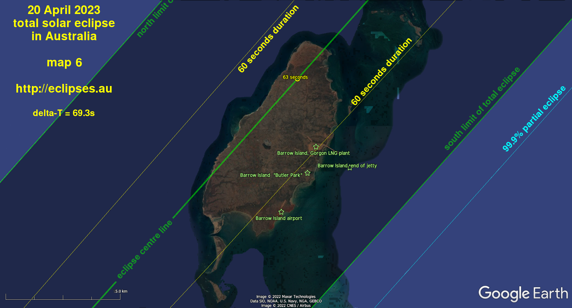
Barrow Island and Montebello Islands
Barrow Island hosts oil & natural gas processing plants and the remainder of the island is a nature reserve. All are closed to the general public; but for the benefit of the island's large workforce we offer the following details.The entire island is inside the path of total eclipse and is crossed by the eclipse centre line. Nearly all of the island gets at least 60 seconds of total eclipse and the maximum duration of 63.1 seconds occurs on the north end of the island. At mid-totality the eclipsed Sun will be just over 56 degrees above the horizon at an azimuth of 19 degrees (north-northeast). We've done a map of the total eclipse path over Barrow Island.
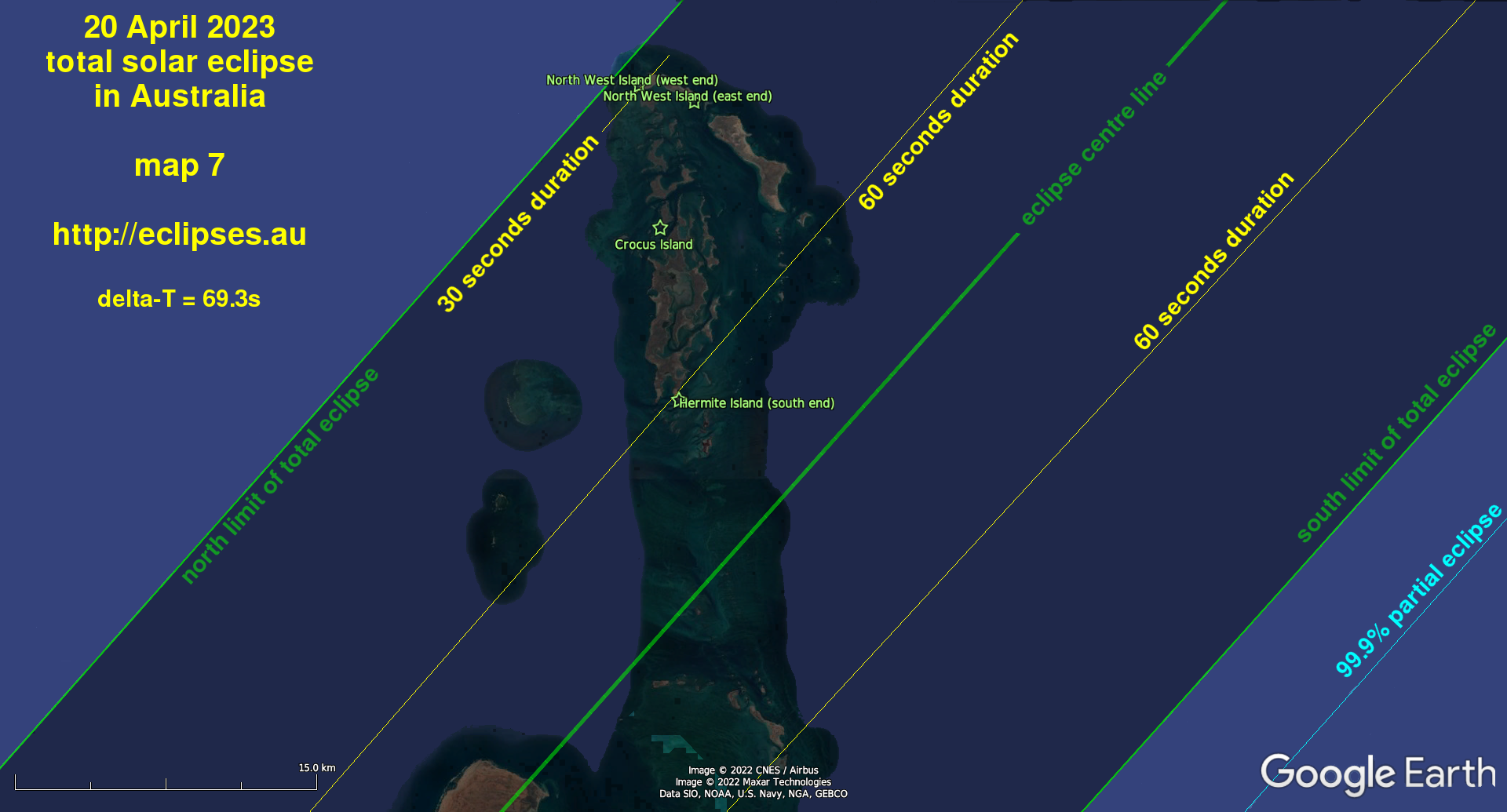
All of the Montebello Islands are inside the northern half of the path of total eclipse. The Islands are a Conservation Park and the waters around them are a Marine Park. A copy of the Park brochure (including detailed maps) can be downloaded here. We've done a map of the total eclipse path over the Montebello Islands too. Visitors will need to be totally self-sufficient because there are zero facilities on the Islands. Also note that portions of some islands should be avoided because they are still radioactive from the nuclear weapons tests in the 1950s.
|
(Scroll sideways if you're viewing this on a small screen) |
|||||
| Location | Western Australia local time (UT +8h) HH:MM:SS | ||||
| partial eclipse begins | total eclipse begins | total eclipse ends | total eclipse duration | partial eclipse ends | |
| Barrow Island airport (car park) | 10:07:27 | 11:33:44.9 | 11:34:43.4 | 58.5 seconds | 13:07:13 |
| Butler Park workers' accommodation camp | 10:07:33 | 11:33:52.5 | 11:34:51.7 | 59.2 seconds | 13:07:23 |
| Gorgon LNG plant (centre of plant area) | 10:07:36 | 11:33:55.9 | 11:34:56.1 | 60.2 seconds | 13:07:28 |
| end of Barrow Island jetty | 10:07:37 | 11:34:01.3 | 11:34:54.7 | 53.4 seconds | 13:07:30 |
Montebello Islands |
|||||
| Crocus Island | 10:08:09 | 11:34:45.4 | 11:35:33.4 | 48.0 seconds | 13:08:20 |
| Hermite Island (south end) | 10:08:03 | 11:34:33.6 | 11:35:34.1 | 60.4 seconds | 13:08:11 |
| North West Island (west end) | 10:08:13 | 11:34:59.5 | 11:35:28.3 | 28.8 seconds | 13:08:25 |
| North West Island (east end) | 10:08:14 | 11:34:54.7 | 11:35:36.8 | 42.1 seconds | 13:08:28 |
|
(Scroll sideways if you're viewing this on a small screen) |
|||||
| Location | Western Australia local time (UT +8h) HH:MM:SS | ||||
| partial eclipse begins | total eclipse begins | total eclipse ends | total eclipse duration | partial eclipse ends | |
| lat 25.3159° S long 110.7989° E | 09:57:09 | 11:19:28.9 | 11:20:22.9 | 54.0 seconds | 12:49:52 |
| lat 24.8387° S long 111.3036° E | 09:58:09 | 11:20:54.4 | 11:21:49.4 | 55.0 seconds | 12:51:40 |
| lat 24.3776° S long 111.7849° E | 09:59:08 | 11:22:18.1 | 11:23:14.1 | 56.0 seconds | 12:53:24 |
| lat 23.8850° S long 112.2890° E | 10:00:12 | 11:23:48.0 | 11:24:45.0 | 57.0 seconds | 12:55:16 |
| lat 23.3843° S long 112.8028° E | 10:01:20 | 11:25:22.0 | 11:26:20.0 | 58.0 seconds | 12:57:12 |
| lat 22.8434° S long 113.3452° E | 10:02:33 | 11:27:03.9 | 11:28:02.9 | 59.0 seconds | 12:59:17 |
| lat 22.3636° S long 113.8214° E (on North West Cape peninsula) | 10:03:40 | 11:28:35.6 | 11:29:35.6 | 60.0 seconds | 13:01:08 |
| lat 21.8028° S long 114.3716° E | 10:05:00 | 11:30:24.2 | 11:31:25.2 | 61.0 seconds | 13:03:18 |
| lat 21.2653° S long 114.8934° E | 10:06:18 | 11:32:09.6 | 11:33:11.6 | 62.0 seconds | 13:05:24 |
| lat 20.7101° S long 115.4264° E (on Barrow Island) | 10:07:40 | 11:34:00.0 | 11:35:03.0 | 63.0 seconds | 13:07:34 |
| lat 20.1225° S long 115.9850° E | 10:09:09 | 11:35:58.4 | 11:37:02.4 | 64.0 seconds | 13:09:52 |
| lat 19.4931° S long 116.5777° E | 10:10:46 | 11:38:07.0 | 11:39:12.0 | 65.0 seconds | 13:12:21 |
| lat 18.8647° S long 117.1644° E | 10:12:26 | 11:40:17.4 | 11:41:23.4 | 66.0 seconds | 13:14:50 |
| lat 17.6250° S long 118.3100° E (west of Cunningham Island) | 10:15:49 | 11:44:40.0 | 11:45:48.0 | 68.0 seconds | 13:19:46 |
| lat 16.0817° S long 119.7215° E | 10:20:14 | 11:50:17.5 | 11:51:27.5 | 70.0 seconds | 13:25:56 |
| lat 14.1968° S long 121.4410° E (west of Scott Reef) | 10:26:00 | 11:57:25.7 | 11:58:37.7 | 72.0 seconds | 13:33:30 |
| lat 12.3274° S long 123.1641° E (southeast of Ashmore Reef) | 10:34:06 | 12:04:48.1 | 12:06:01.6 | 73.5 seconds | 13:41:03 |
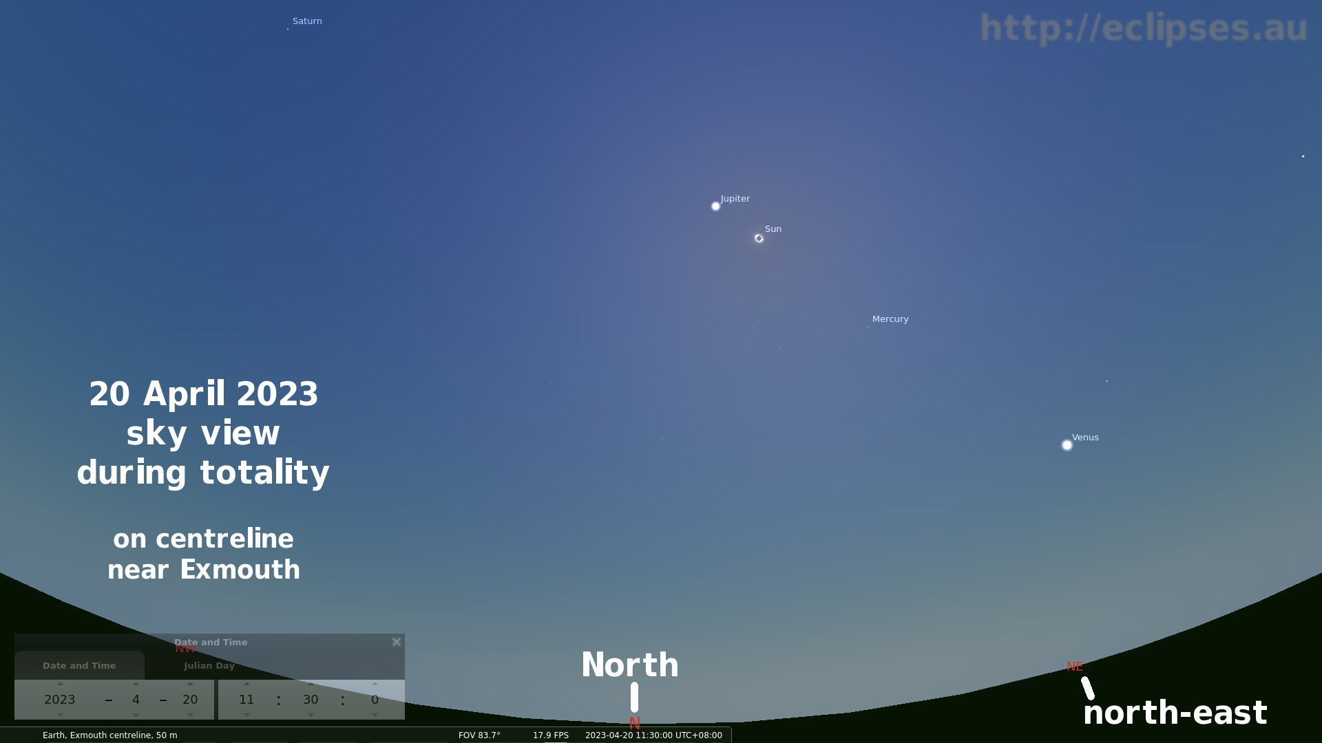
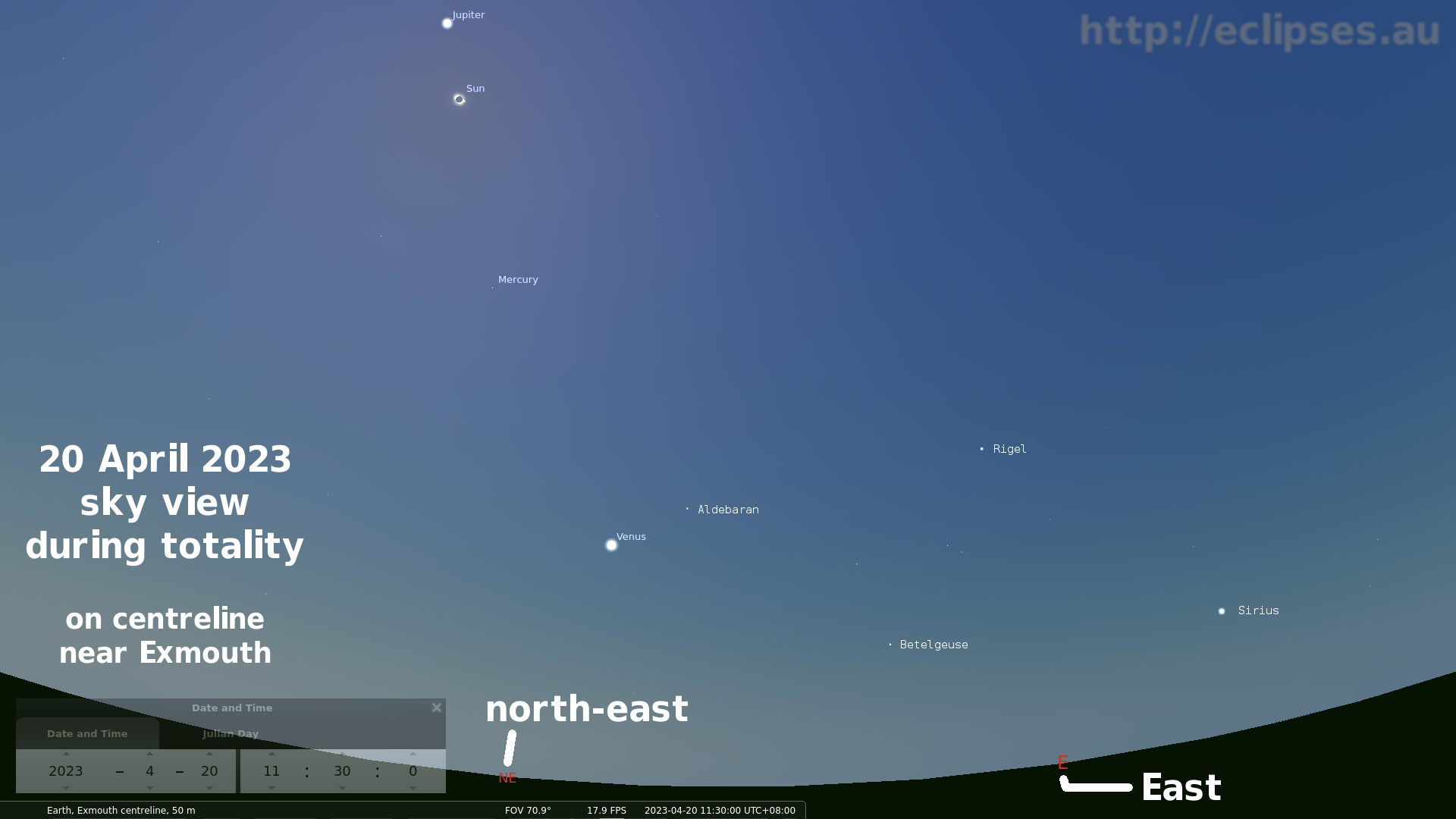
The sky view during total eclipse
Because the moon's shadow is less than 50km wide when it crosses Exmouth the sky around this total eclipse is expected to be relatively bright; similar to a twilight sky about 20 minutes after sunset. This sky brightness plus the short duration of total eclipse reduces your chances of spotting other things up there. The bright planets Venus and Jupiter should be obvious, and you will probably eyeball Saturn and the star Sirius as well. But Mercury and the stars Aldebaran, Betelgeuse and Rigel may not be obvious unless the air is clear (or you use binoculars). The Southern Cross (Crux) and both of the "Pointers" (Alpha & Beta Centauri) are beneath the southern horizon during the eclipse; but will be visible all night during April.The views below were generated for the eclipse centreline near Exmouth at mid-eclipse.
Click the views for a larger image (in new window).
Selected eclipse times elsewhere in Australia (a partial eclipse)
|
(Scroll sideways if you're viewing this on a small screen) |
||||
| Location | local times HH:MM:SS | |||
| partial eclipse begins | maximum partial eclipse | maximum obscuration % | partial eclipse ends | |
| New South Wales and ACT (time zone UT +10h) | ||||
| Broken Hill (UT +9h30m) | 12:33:19 | 13:40:56 | 21 | 14:46:43 |
| Canberra | 13:29:36 | 14:21:58 | 10 | 15:12:19 |
| Cobar | 13:18:22 | 14:21:34 | 17 | 15:22:07 |
| Griffith | 13:18:51 | 14:17:07 | 13 | 15:13:20 |
| Sydney | 13:36:44 | 14:28:52 | 10 | 15:18:39 |
| Tamworth | 13:35:59 | 14:33:29 | 13 | 15:27:52 |
| Tibooburra | 13:05:46 | 14:16:52 | 24 | 15:25:25 |
| Northern Territory (time zone UT +9h30m) | ||||
| Alice Springs | 12:12:55 | 13:37:49 | 48 | 15:01:52 |
| Darwin | 12:17:41 | 13:52:29 | 80.6 | 15:25:30 |
| Katherine | 12:18:13 | 13:51:45 | 72 | 15:23:14 |
| Nhulunbuy | 12:33:30 | 14:07:15 | 68 | 15:35:49 |
| Tennant Creek | 12:17:13 | 13:46:06 | 56 | 15:13:08 |
| Yulara | 12:03:59 | 13:28:33 | 51 | 14:53:45 |
| Queensland (time zone UT +10h) | ||||
| Birdsville | 12:58:15 | 14:16:41 | 34 | 15:32:33 |
| Brisbane | 13:43:37 | 14:44:54 | 16 | 15:41:52 |
| Charleville | 13:21:09 | 14:31:57 | 24 | 15:38:35 |
| Longreach | 13:15:48 | 14:32:59 | 31 | 15:45:28 |
| Mount Isa | 13:02:06 | 14:26:48 | 43 | 15:47:33 |
| Rockhampton | 13:36:52 | 14:47:29 | 24 | 15:52:25 |
| Townsville | 13:27:04 | 14:47:09 | 36 | 16:00:33 |
| Weipa | 13:17:45 | 14:48:29 | 58 | 16:11:49 |
| South Australia (time zone UT +9h30m) | ||||
| Adelaide | 12:23:41 | 13:30:00 | 21 | 14:35:28 |
| Ceduna | 12:08:51 | 13:23:37 | 33 | 14:38:36 |
| Coober Pedy | 12:12:42 | 13:30:44 | 36 | 14:48:20 |
| Marree | 12:22:39 | 13:37:09 | 29 | 14:50:12 |
| Mount Gambier | 12:31:09 | 13:30:24 | 15 | 14:28:44 |
| Whyalla | 12:20:27 | 13:30:36 | 25 | 14:39:57 |
| Victoria and Tasmania (time zone UT +10h) | ||||
| Echuca | 13:14:23 | 14:11:15 | 13 | 15:06:33 |
| Hobart | 13:24:33 | 14:05:57 | 5 | 14:46:38 |
| Mallacoota | 13:31:54 | 14:19:15 | 7 | 15:05:04 |
| Melbourne | 13:15:18 | 14:09:02 | 11 | 15:01:25 |
| Mildura | 13:05:25 | 14:08:45 | 18 | 15:10:31 |
| Western Australia (time zone UT +8h) (Exmouth region and Barrow Island and Montebello Islands times are listed above) |
||||
| Albany | 10:02:57 | 11:20:50 | 59 | 12:43:26 |
| Broome | 10:21:43 | 11:52:33 | 89.4 | 13:27:00 |
| Carnarvon | 10:00:56 | 11:25:14 | 94.7 | 12:56:08 |
| Christmas Island (UT +7h) | 09:17:39 | 10:34:44 | 46.4 | 11:58:14 |
| Cocos (Home) Island (UT +6.5h) | 08:42:02 | 09:47:12 | 29.5 | 10:58:24 |
| Coral Bay | 10:02:46 | 11:27:52 | 99.04 | 12:59:35 |
| Esperance | 10:10:14 | 11:28:38 | 53 | 12:50:51 |
| Eucla (UT +8h45m) | 11.11.02 | 12:29:20 | 42 | 13:49:26 |
| Geraldton | 09:59:27 | 11:21:57 | 81.9 | 12:50:36 |
| Kalgoorlie | 10:09:55 | 11:31:23 | 60 | 12:57:03 |
| Karratha | 10:09:35 | 11:37:07 | 97.1 | 13:10:25 |
| Kununurra | 10:37:54 | 12:10:55 | 78 | 13:44:05 |
| Mount Magnet | 10:04:41 | 11:28:17 | 76 | 12:57:18 |
| Newman | 10:11:16 | 11:38:24 | 82.5 | 13:10:28 |
| Onslow | 10:06:09 | 11:32:31 | 99.41 | 13:05:09 |
| Perth | 10:00:00 | 11:20:30 | 71 | 12:46:33 |
| Port Hedland | 10:12:40 | 11:41:06 | 93.2 | 13:14:45 |
| Tom Price | 10:08:48 | 11:35:46 | 89.4 | 13:08:17 |
| Wiluna | 10:09:34 | 11:34:32 | 73 | 13:04:16 |
The five eclipses: 20 Apr 2023 -- 22 Jul 2028 -- 25 Nov 2030 -- 13 Jul 2037 -- 26 Dec 2038