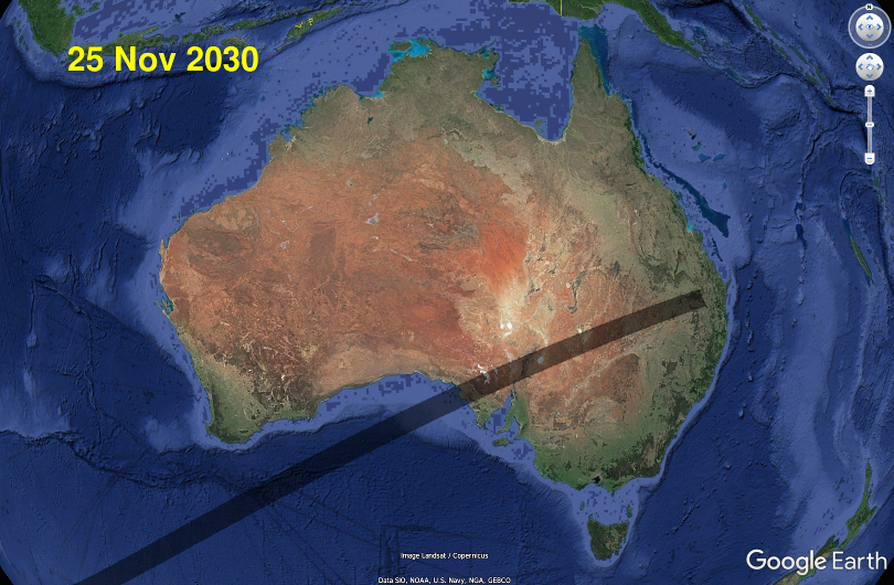
The 25 November 2030 Total Solar Eclipse in New South Wales
Time remaining until total eclipse begins on centre line:
See the page for South Australia for a taste of what this page will include when it's finished...
Skip to:
- eclipse maps for NSW
- weather forecasts
- eclipse times for NSW locations
- Tourism information.
Also see the detailed eclipse pages for:
- South Australia (SA)
- Queensland (QLD)
- The rest of Australia, on the 2030 eclipse homepage.
Locations in the far west and southwest of NSW, such as Broken Hill or Deniliquin, will see this eclipse from beginning to end before their sunset.
Eclipse maps for New South Wales
Overview of the total eclipse path in northwestern New South Wales
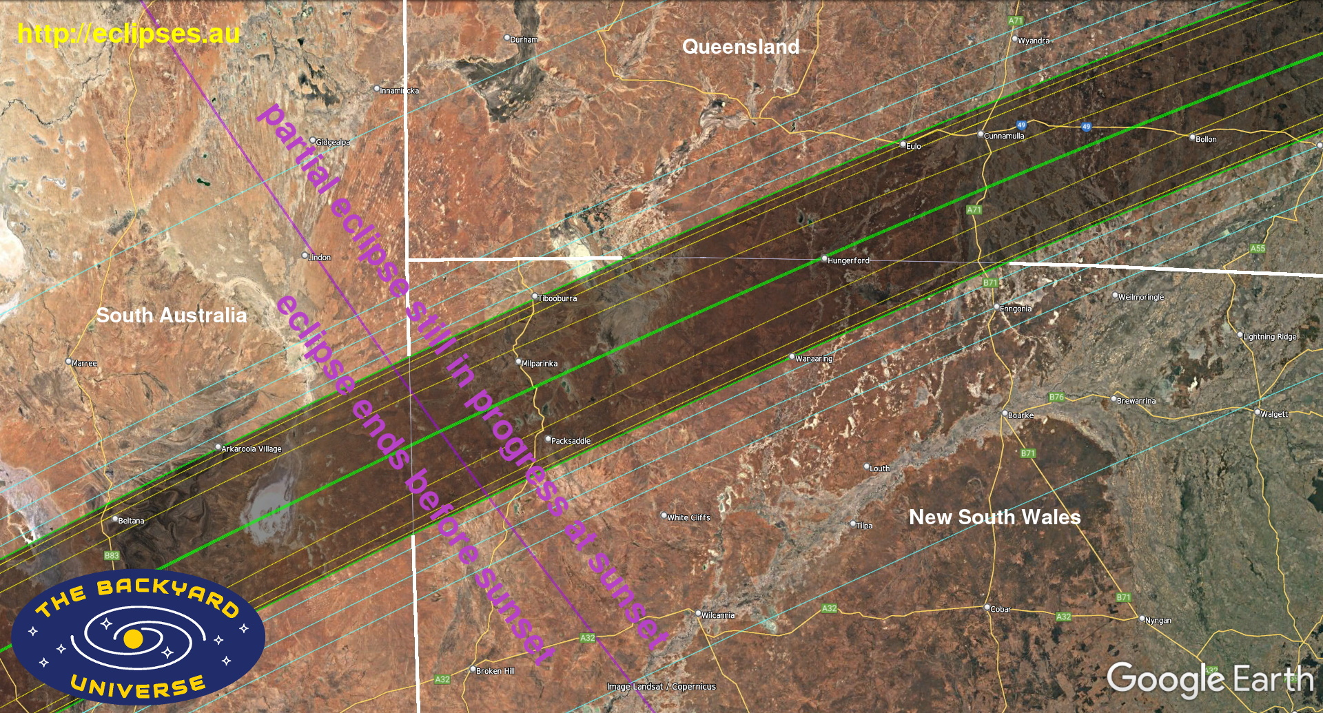
What are all the coloured lines and symbols on these maps? Click on the image below for the explanation:
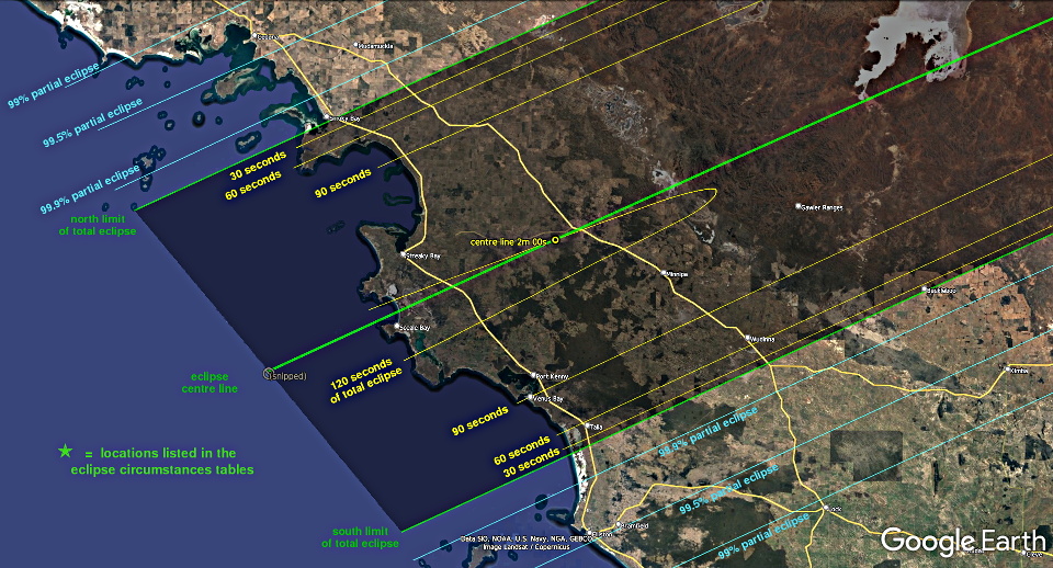
What are all the coloured lines and symbols on these maps? Click on the image below for the explanation:

Weather for New South Wales
7 day weather forecasts for New South Wales, and for Tibooburra.High resolution weather satellite images.
|
(Scroll sideways if you're viewing this on a small screen) |
||||||
| Location | New South Wales local time (UT +11h on eclipse day) HH:MM:SS
All event times for total and nearly-total eclipses have been corrected for the moon's actual topography. |
|||||
| partial eclipse begins | total eclipse begins | total eclipse ends | maximum partial eclipse (if not total) |
maximum sun obscuration % (if partial) -- or -- total eclipse duration (mm:ss.s) |
partial eclipse ends (at sunset for most NSW locations) |
|
| Albury | 18:22:01 | none | none | 19:17:23 | 77.6 | 20:08 (sunset) |
| Allundy station | 18:26:40 | 19:23:33.4 | 19:24:18.4 | - | total 45.0s | 20:08 (sunset) |
| Australia Telescope Compact Array, near Narrabri | 18:27:42 | none | none | 19:22:32 | 92.0 | 19:44 (sunset) |
| Avenel station | 18:24:45 | 19:22:45.9 | 19:23:29.8 | - | total 43.9s | 20:16:24 (sunset 20:20) |
| Balranald | 18:22:04 | none | none | 19:19:12 | 86.0 | 20:11:42 (sunset 20:18) |
| Barrona Downs station | 18:26:39 | 19:23:18.5 | 19:24:52.4 | - | total 1m 33.8s | 20:09 (sunset) |
| Batemans Bay | 18:23:16 | none | none | 19:17:13 | 74.8 | 19:54 (sunset) |
| Bathurst | 18:25:02 | none | none | 19:19:37 | 82.4 | 19:51 (sunset) |
| Bindara station | 18:27:21 | 19:24:27.4 | 19:24:58.3 | - | total 30.9s | 20:09 (sunset) |
| Border Downs station | 18:25:20 | 19:22:43.2 | 19:24:32.1 | - | total 1m 48.9s | 20:16:54 (sunset 20:18) |
| Bourke | 18:27:09 | none | none | 19:23:27 | 97.26 | 19:59 (sunset) |
| Broken Hill ( *South Australia time zone*) | *17:53:49 | none | none | *18:52:03 | 97.02 | *19:45:17 (sunset 19:50) |
| Bush Tucker caravan park (Mitchell Highway B71) | 18:28:07 | 19:23:59.6 | 19:24:54.0 | - | total 54.4s | 19:57 (sunset) |
| Casino | 18:29:17 | none | none | 19:22:48 | 92.2 | 19:28 (sunset) |
| Centre Line on Mount Shannon Road lat 30.1168° S long 141.5546° E | 18:25:45 | 19:22:56.4 | 19:24:43.5 | - | total 1m 47.1s | 20:16 (sunset) |
| Centre Line on Silver City Highway (A79) lat 29.9293° S long 142.0312° E | 18:26:07 | 19:23:06.0 | 19:24:52.2 | - | total 1m 46.2s | 20:14 (sunset) |
| Centre Line on The Cut Line lat 29.7107° S long 142.5889° E | 18:26:32 | 19:23:16.7 | 19:25:02.0 | - | total 1m 45.3s | 20:11 (sunset) |
| Coally station | 18:26:07 | 19:23:06.1 | 19:24:52.2 | - | total 1m 46.1s | 21:14 (sunset) |
| Cobar | 18:25:47 | none | none | 19:22:08 | 93.0 | 20:02 (sunset) |
| Coffs Harbour | 18:28:08 | none | none | 19:21:34 | 87.6 | 19:30 (sunset) |
| Connulpie station | 18:26:59 | 19:24:02.4 | 19:25:10.9 | - | total 1m 08.6s | 20:10 (sunset) |
| Coonabarabran | 18:26:48 | none | none | 19:21:43 | 89.3 | 19:48 (sunset) |
| Corner Country Holiday Camp | 18:26:15 | 19:23:07.6 | 19:24:54.4 | - | total 1m 46.8s | 20:13 (sunset) |
| Cowra | 18:24:28 | none | none | 19:19:23 | 82.1 | 19:56 (sunset) |
| Deniliquin | 18:21:48 | none | none | 19:18:10 | 81.6 | 20:15 (sunset) |
| Dubbo | 18:25:49 | none | none | 19:20:56 | 87.1 | 19:53 (sunset) |
| Engonnia | 18:27:51 | almost | almost | 19:24:10 | 99.53 | 19:57 (sunset) |
| Fowlers Gap station | 18:24:49 | almost | almost | 19:22:55 | 99.26 | 20:16:01 (sunset 20:18) |
| Glen Innes | 18:28:28 | none | none | 19:22:28 | 91.1 | 19:35 (sunset) |
| Gosford | 18:25:22 | none | none | 19:19:13 | 80.1 | 19:44 (sunset) |
| Goulburn | 18:23:56 | none | none | 19:18:16 | 78.1 | 19:54 (sunset) |
| Griffith | 18:23:18 | none | none | 19:19:20 | 84.0 | 20:07 (sunset) |
| Gum Vale station | 18:26:30 | 19:23:58.1 | 19:24:50.1 | - | total 52.0s | 20:14 (sunset) |
| Hay | 18:22:41 | none | none | 19:19:15 | 84.9 | 20:13 (sunset) |
| Hewart Downs airstrip | 18:26:17 | 19:24:14.5 | 19:24:22.6 | - | total 08.0s | 20:16 (sunset) |
| Hewart Downs station | 18:26:18 | almost | almost | 19:24:27 | 99.96 | 20:16 (sunset) |
| intersection Bourke Milparinka Road + Mooleyarrah Road | 18:27:03 | almost | almost | 19:24:01 | 99.98 | 20:04 (sunset) |
| intersection Cameron Corner Road + Toona Gate Road | 18:26:42 | almost | almost | 19:24:41 | 99.72 | 20:14 (sunset) |
| intersection Henry Roberts Road + Kayrunnera Road | 18:25:35 | almost | almost | 19:23:18 | 99.49 | 20:13 (sunset) |
| intersection Silver City Highway (A79) + Henry Roberts Road | 18:25:49 | 19:22:59.3 | 19:24:27.7 | - | total 1m 28.4s | 20:14 (sunset) |
| intersection Silver City Highway (A79) + Sanpah Road | 18:25:08 | almost | almost | 19:23:11 | 99.8 | 20:16:14 (sunset 20:17) |
| intersection Silver City Highway (A79) + Wompah Gate Road | 18:26:49 | almost | almost | 19:24:40 | 99.96 | 20:12 (sunset) |
| intersection The Cut Line + Tibooburra Road | 18:26:30 | 19:23:20.6 | 19:25:03.1 | - | total 1m 42.5s | 20:12 (sunset) |
| intersection Yancannia Road + Bootra Road | 18:26:00 | 19:23:24.7 | 19:23:31.5 | - | total 06.8s | 20:12 (sunset) |
| Inverell | 18:28:23 | none | none | 19:22:37 | 91.8 | 19:37 (sunset) |
| Ivanhoe | 18:23:59 | none | none | 19:20:56 | 90.5 | 20:11 (sunset) |
| Jindabyne | 18:22:15 | none | none | 19:16:43 | 74.5 | 20:02 (sunset) |
| Joulnie station | 18:24:54 | 19:22:50.6 | 19:23:29.4 | - | total 38.8s | 20:16:24 (sunset 20:19) |
| Koridina station | 18:26:55 | 19:23:27.4 | 19:24:51.0 | - | total 1m 23.6s | 20:07 (sunset) |
| Lake Cargelligo | 18:24:18 | none | none | 19:20:18 | 86.7 | 20:04 (sunset) |
| Lightning Ridge | 18:28:12 | none | none | 19:23:40 | 96.78 | 19:49 (sunset) |
| Lismore | 18:29:21 | none | none | 19:22:47 | 92.1 | 19:26 (sunset) |
| Lord Howe Island ** | 18:27:23 | none | none | 19:09 (sunset) | **62 | 19:09 (sunset) |
| Louth | 18:26:30 | none | none | 19:23:09 | 96.9 | 20:03 (sunset) |
| Menindee | 18:23:46 | none | none | 19:21:35 | 94.5 | 20:18 (sunset) |
| Merimbula | 18:22:14 | none | none | 19:16:03 | 71.7 | 19:59 (sunset) |
| Milanda station | 18:27:53 | almost | almost | 19:24:18 | 99.95 | 19:58 (sunset) |
| Milpa station | 18:25:36 | 19:22:59.1 | 19:24:01.0 | - | total 1m 01.9s | 20:15 (sunset) |
| Milparinka | 18:26:16 | 19:23:21.9 | 19:24:58.6 | - | total 1m 36.7s | 20:14 (sunset) |
| Mooleyarrah station | 18:27:24 | 19:23:40.3 | 19:24:54.5 | - | total 1m 14.2s | 20:03 (sunset) |
| Moree | 18:28:28 | none | none | 19:23:12 | 94.3 | 19:42 (sunset) |
| Mount Arrowsmith (summit) | 18:25:47 | 19:22:56.1 | 19:24:43.7 | - | total 1m 47.7s | 20:16 (sunset) |
| Mount Browne station | 18:26:10 | 19:23:18.1 | 19:24:56.0 | - | total 1m 37.9s | 20:15 (sunset) |
| Mount Poole station Depot Glen | 18:26:18 | 19:23:31.4 | 19:24:59.4 | - | total 1m 28.0s | 20:14 (sunset) |
| Mount Shannon station | 18:26:00 | 19:23:08.5 | 19:24:51.6 | - | total 1m 43.2s | 20:15 (sunset) |
| Mount Wood station | 18:26:39 | 19:23:40.8 | 19:25:07.5 | - | total 1m 26.7s | 20:12 (sunset) |
| Mungindi (straddles NSW/QLD state border) | 18:28:47 | none | none | 19:23;51 | 96.9 | 19:44 (sunset) |
| Muswellbrook | 18:26:15 | none | none | 19:20:25 | 84.3 | 19:43 (sunset) |
| Mutawintji campground | 18:24:50 | none | none | 19:22:42 | 98.1 | 20:16 (sunset) |
| Myrnong station | 18:26:43 | almost | almost | 19:23:53 | 99.96 | 20:07 (sunset) |
| Nangunyah station | 18:27:30 | 19:23:37.1 | 19:25:20.8 | - | total 1m 43.7s | 20:04 (sunset) |
| Narcowla station | 18:26:56 | 19:24:27.4 | 19:24:40.6 | - | total 13.2s | 20:11 (sunset) |
| Nardoo station (NSW) | 18:27:14 | 19:23:35.5 | 19:24:55.1 | - | total 1m 19.6s | 20:05 (sunset) |
| Naree station | 18:27:47 | 19:23:49.7 | 19:24:58.0 | - | total 1m 08.3s | 20:00 (sunset) |
| Narrabri | 18:27:43 | none | none | 19:22:28 | 91.7 | 19:43 (sunset) |
| Narriearra station | 18:26:54 | 19:23:50.2 | 19:25:12.3 | - | total 1m 22.1s | 20:11 (sunset) |
| Newcastle | 18:25:52 | none | none | 19:19:36 | 81.2 | 19:42 (sunset) |
| North Limit on Cameron Corner Road lat 29.3762° S long 141.8318° E | 18:26:37 | 19:24:32.9 | 19:24:32.9 | - | north limit | 20:14 (sunset) |
| North Limit on Silver City Highway (A79) lat 29.2974° S long 142.0286° E | 18:26:46 | 19.24.36.8 | 19:24:36.8 | - | north limit | 20:13 (sunset) |
| Nowra | 18:24:02 | none | none | 19:17:58 | 76.7 | 19:51 (sunset) |
| Nyngan | 18:26:05 | none | none | 19:21:51 | 91.1 | 19:57 (sunset) |
| One Tree station | 18:26:00 | 19:23:00.4 | 19:24:47.8 | - | total 1m 47.4s | 20:14 (sunset) |
| Orange | 18:25:02 | none | none | 19:19:51 | 83.3 | 19:53 (sunset) |
| Packsaddle Roadhouse | 18:25:24 | almost | almost | 19:23:22 | 99.99 | 20:16 (sunset) |
| Parkes | 18:24:56 | none | none | 19:20:10 | 85.0 | 19:56 (sunset) |
| Parkes Radio Telescope | 18:25:05 | none | none | 19:20:17 | 85.3 | 19:56 (sunset) |
| Peak Hill station | 18:26:13 | 19:23:16.6 | 19:24:57.3 | - | total 1m 40.7s | 21:14 (sunset) |
| Petita station | 18:26:21 | 19:23:25.7 | 19:24:11.2 | - | total 45.5s | 20:10 (sunset) |
| Pindera Downs station | 18:26:43 | 19:23:40.4 | 19:25:10.6 | - | total 1m 30.2s | 20:11 (sunset) |
| Pine Ridge station | 18:25:10 | 19:22:45.7 | 19:23:59.5 | - | total 1m 13.8s | 20:16:32 (sunset 20:18) |
| Pine View station | 18:24:58 | 19:22:37.5 | 19:24:02.8 | - | total 1m 25.2s | 20:16:36 (sunset 20:19) |
| Port Macquarie | 18:27:12 | none | none | 19:20:38 | 84.3 | 19:34 (sunset) |
| Rainbow Rocks | 18:26:58 | almost | almost | 19:24:43 | 99.97 | 20:11 (sunset) |
| Salisbury Downs station | 18:26:21 | 19:23:11.3 | 19:24:44.6 | - | total 1m 33.3s | 20:11 (sunset) |
| Sanpah station | 18:25:12 | 19:22:42.2 | 19:24:14.3 | - | total 1m 32.1s | 20:16:39 (sunset 20:18) |
| Sharoon station | 18:28:01 | 19:24:01.7 | 19:24:48.5 | - | total 46.8s | 19:58 (sunset) |
| Siding Spring Observatory | 18:26:46 | none | none | 19:21:46 | 89.6 | 19:49 (sunset) |
| Silverton ( *South Australia time zone*) | *17:53:48 | none | none | *18:52:08 | 97.5 | *19:45:27 (sunset 19:51) |
| South Limit on Border Downs Road lat 30.9262° S long 141.1247° E | 18:24:45 | 19:23:05.3 | 19:23:05.3 | - | south limit | 20:16:22 (sunset 20:20) |
| South Limit on Bourke Milparinka Road (1), near Wanaaring lat 29.7075° S long 144.1780° E | 18:27:02 | 19:24:02.1 | 19:24:02.1 | - | south limit | 20:05 (sunset) |
| South Limit on Bourke Milparinka Road (2), near Wanaaring lat 29.7315° S long 144.1179° E | 18:27:00 | 19:24:01.2 | 19:24:01.2 | - | south limit | 20:05 (sunset) |
| South Limit on Henry Roberts Road lat 30.4186° S long 142.3970° E | 18:25:45 | 19:23:31.5 | 19:23:31.5 | - | south limit | 20:14 (sunset) |
| South Limit on Hungerford Road lat 29.3718° S long 145.0180° E | 18:27:36 | 19:24:14.3 | 19:24:14.3 | - | south limit | 20:01 (sunset) |
| South Limit on Mitchell Highway (B71) lat 29.0735° S long 145.7656° E | 18:28:04 | 19:24:23.3 | 19:24:23.3 | - | south limit | 19:57 (sunset) |
| South Limit on Sanpah Road lat 30.7518° S long 141.5613° E | 18:25:06 | 19:23:14.8 | 19:23:14.8 | - | south limit | 20:16:22 (sunset 20:18) |
| South Limit on Silver City Highway (A79) lat 30.5872° S long 141.9736° E | 18:25:25 | 19:23:23.2 | 19:23:23.2 | - | south limit | 20:16 (sunset) |
| Stone Hut station | 18:26:26 | 19:24:19.5 | 19:24:25.3 | - | total 05.8s | 20:15 (sunset) |
| Sydney (observatory) | 18:25:00 | none | none | 19:18:50 | 79.0 | 19:46 (sunset) |
| Talyealye station | 18:27:42 | 19:23:41.0 | 19:25:21.2 | - | total 1m 40.2s | 20:02 (sunset) |
| Tamworth | 18:27:14 | none | none | 19:21:29 | 87.9 | 19:41 (sunset) |
| Teilta station | 18:24:47 | almost | almost | 19:23:05 | 99.97 | 20:16:20 (sunset 20:19) |
| Temora | 18:23:37 | none | none | 19:18:58 | 81.7 | 20:02 (sunset) |
| Tenterfield | 18:29:04 | none | none | 19:22:58 | 92.9 | 19:32 (sunset) |
| Tero Creek station | 18:26:08 | 19:23:13.1 | 19:24:14.1 | - | total 1m 01.1s | 20:11 (sunset) |
| The Range station | 18:26:28 | almost | almost | 19:23:46 | 99.9 | 20:08 (sunset) |
| Theldarpa station | 18:26:12 | 19:23:41.7 | 19:24:52.9 | - | total 1m 11.3s | 20:16 (sunset) |
| Thurloo Downs station | 18:27:15 | 19:23:37.2 | 19:25:19.0 | - | total 1m 41,8s | 20:07 (sunset) |
| Tibooburra | 18:26:37 | 19:23:54.5 | 19:25:01.9 | - | total 1m 07.4s | 20:13 (sunset) |
| Tibooburra airport | 18:26:37 | 19:23:50.0 | 19:25:03.9 | - | total 1m 14.0s | 20:13 (sunset) |
| Tilpa | 18:25:54 | none | none | 19:22:51 | 96.5 | 20:07 (sunset) |
| Tweed Heads | 18:29:53 | none | none | 19:23:12 | 93.8 | 19:24 (sunset) |
| Ularara station | 18:26:57 | almost | almost | 19:23:58 | 99.96 | 20:05 (sunset) |
| Urella Downs | 18:26:48 | 19:23:20.6 | 19:25:06.1 | - | total 1m 45.5s | 20:09 (sunset) |
| Wagga Wagga | 18:22:58 | none | none | 19:18:18 | 79.9 | 20:04 (sunset) |
| Walgett | 18:27:42 | none | none | 19:23:07 | 94.8 | 19:50 (sunset) |
| Wanaaring | 18:27:02 | 19:23:46.8 | 19:24:06.2 | - | total 19.5s | 20:05 (sunset) |
| Weebah station | 18:27:43 | 19:23:48.6 | 19:25:28.8 | - | total 1m 40.2s | 20:03 (sunset) |
| Weilmoringle | 18:28:10 | none | none | 19:24:03 | 98.6 | 19:53 (sunset) |
| White Cliffs | 18:25:33 | none | none | 19:23:03 | 98.38 | 20:12 (sunset) |
| Wilcannia | 18:24:57 | none | none | 19:22:21 | 95.9 | 20:12 (sunset) |
| Winnathee station | 18:25:57 | 19:23:41.0 | 19:24:41.3 | - | total 1m 00.3s | 20:17 (sunset) |
| Winrae station | 18:28:04 | almost | almost | 19:24:23 | 99.99 | 19:57 (sunset) |
| Wollongong | 18:24:29 | none | none | 19:18:21 | 77.7 | 19:48 (sunset) |
| Womparley station | 18:26:59 | 19:23:34.1 | 19:24:31.7 | - | total 57.5s | 20:06 (sunset) |
| Yalda Downs station | 18:26:06 | almost | almost | 19:23:38 | 99.93 | 20:11 (sunset) |
| Yancannia station | 18:26:02 | 19:23:25.7 | 19:23:30.4 | - | total 04.7s | 20:12 (sunset) |
| Yandama station | 18:26:09 | 19:23:41.2 | 19:24:51.6 | - | total 1m 10.4s | 20:16 (sunset) |
| Yantabula station | 18:27:38 | 19:23:57.0 | 19:24:33.9 | - | total 36.9s | 20:01 (sunset) |
| Yarralee station | 18:27:18 | 19:23:47.2 | 19:25:21.8 | - | total 1m 34.7s | 20:07 (sunset) |
| Yass | 18:23:40 | none | none | 19:18:21 | 78.9 | 19:57 (sunset) |
| Yuccana station | 18:27:33 | almost | almost | 19:24:09 | 99.88 | 20:01 (sunset) |
More information
- Road conditions and traffic restrictions for New South Wales.
- Weather radars homepage, high resolution weather satellite images and weather forecasts.
- Some tourism websites in New South Wales:
- New South Wales tourism.
- Corner Country NSW website (Tibooburra, Milparinka, Packsaddle, and the Silver City Highway).
- Broken Hill city council website.
- Central Darling Shire visitor information
- Bourke Shire council website (Wanaaring).
- New South Wales tourism.
- Aussie Towns contains descriptions of hundreds of Australian towns and localities.
The five eclipses: 20 Apr 2023 -- 22 Jul 2028 -- 25 Nov 2030 -- 13 Jul 2037 -- 26 Dec 2038