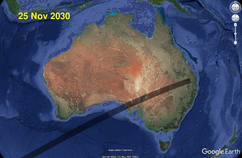
The 25 November 2030 Total Solar Eclipse in South Australia
Time remaining until total eclipse begins on centre line:
- eclipse maps for SA
- total eclipse durations along some SA main roads
- photos from SA locations within (and near) the path of total eclipse
- weather forecasts for SA
- eclipse times for SA locations
- Tourism information.
Also see the detailed eclipse pages for:
- Queensland (QLD)
- New South Wales (NSW)
- The rest of Australia, on the 2030 eclipse homepage.
The longest duration for this total eclipse within Australia is about 122 seconds, near Sceale Bay on the west coast of Eyre Peninsula. Duration decreases inland but there's still up to 111 seconds of total eclipse in the eastern Flinders Ranges. Towns and locations within the total eclipse path include Streaky Bay, Sceale Bay, Venus Bay, Poochera, Wudinna, Wirrula, Hawker, Rawnsley Park, Wilpena, Parachilna, Beltana, Blinman, the entire Gawler Ranges National Park, the entire Ikara-Flinders Ranges National Park
Locations in far northeast SA, such as Innamincka and Gidgealpa, will have their partial eclipse interrupted by (local) sunset. All other SA locations will see their entire eclipse before sunset.
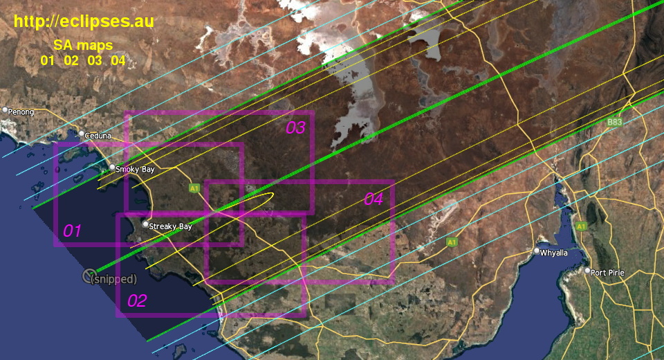
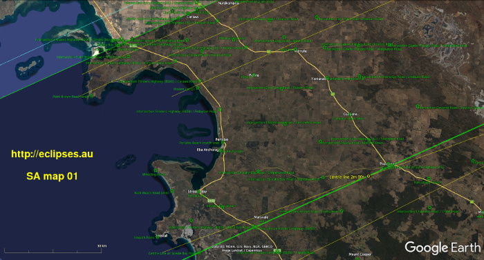
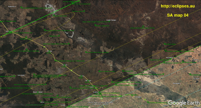
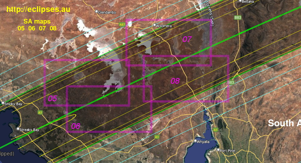
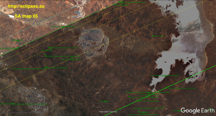
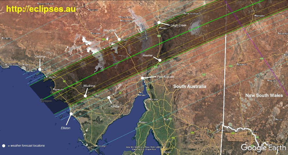
Eclipse maps for South Australia
Overview of the total eclipse path in South Australia
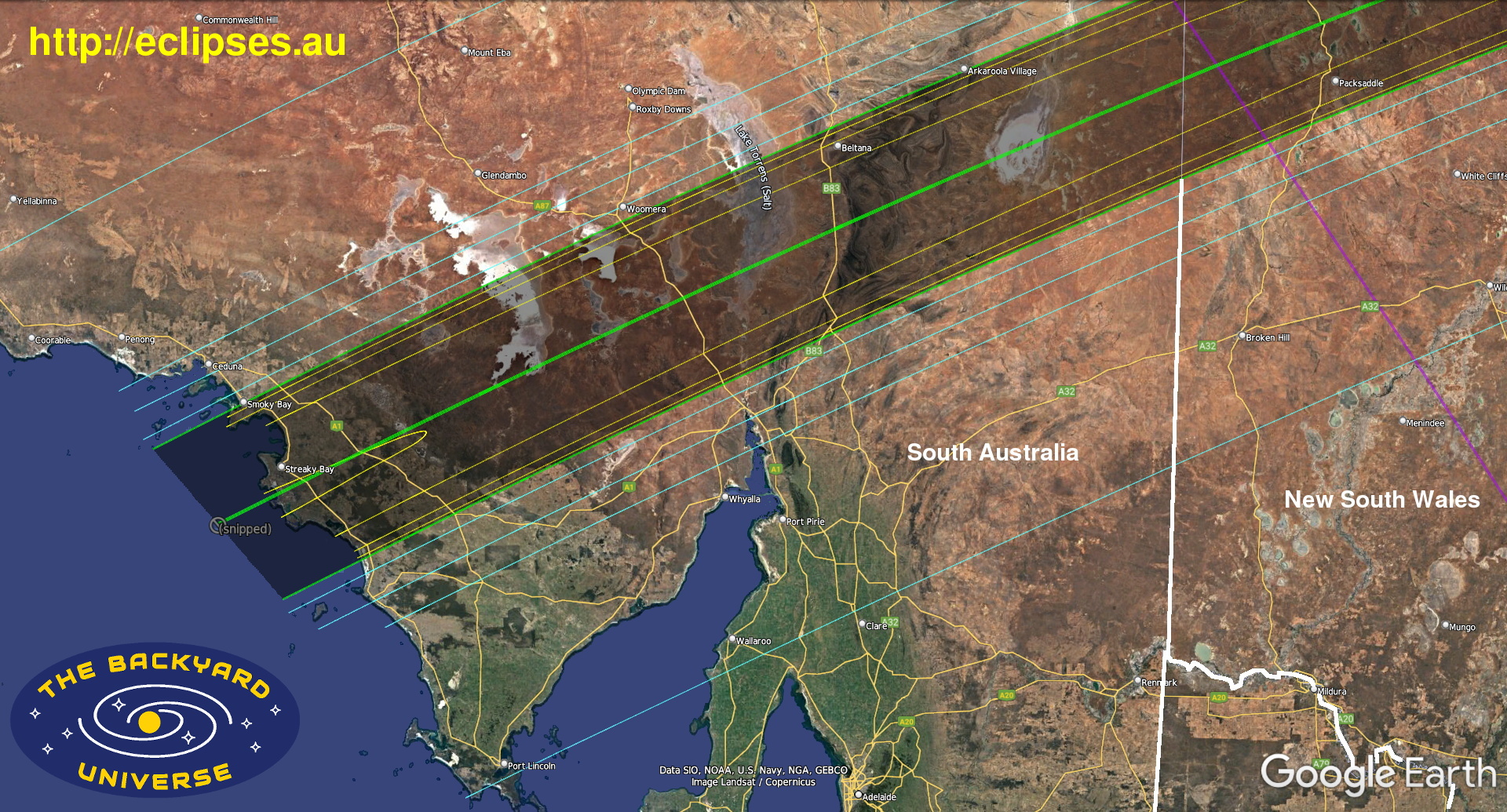
What are all the coloured lines and symbols on these maps? Click on the image below for the explanation:
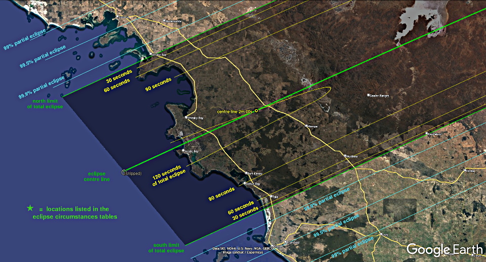
The wide darker-shaded strip, between the green north limit and south limit lines, is the path of the total eclipse.
If you are outside this strip you will not see a total eclipse on 25 November 2030, and you will also not see the most spectacular phenomena that are only visible during a total eclipse.
All of the maps (and durations) have been corrected for the actual lunar topography.
Eclipse maps for South Australia. Click on the detail map image for a bigger version. Also see the location photos below.
Index to the detailed maps 01 to 04 below; for Eyre Peninsula, Eyre Highway and Flinders Highway.


Index to the detailed maps 05 to 08 below; for Gawler Ranges and Stuart Highway.

Index to the detailed maps 09 to 12 below; for Flinders Ranges.
What are all the coloured lines and symbols on these maps? Click on the image below for the explanation:

The wide darker-shaded strip, between the green north limit and south limit lines, is the path of the total eclipse.
If you are outside this strip you will not see a total eclipse on 25 November 2030, and you will also not see the most spectacular phenomena that are only visible during a total eclipse.
All of the maps (and durations) have been corrected for the actual lunar topography.
Eclipse maps for South Australia. Click on the detail map image for a bigger version. Also see the location photos below.
Index to the detailed maps 01 to 04 below; for Eyre Peninsula, Eyre Highway and Flinders Highway.


Index to the detailed maps 05 to 08 below; for Gawler Ranges and Stuart Highway.


Index to the detailed maps 09 to 12 below; for Flinders Ranges.


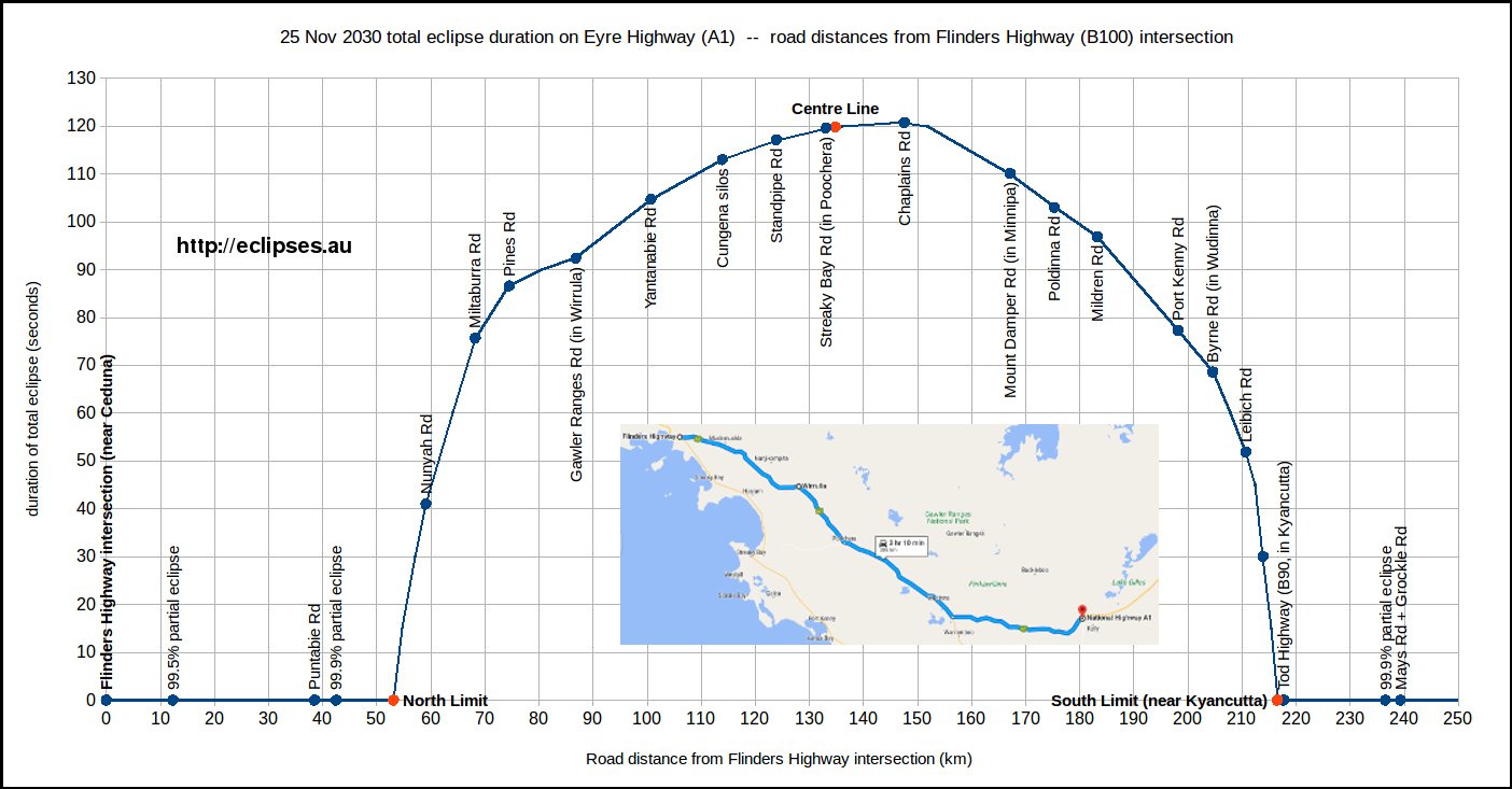
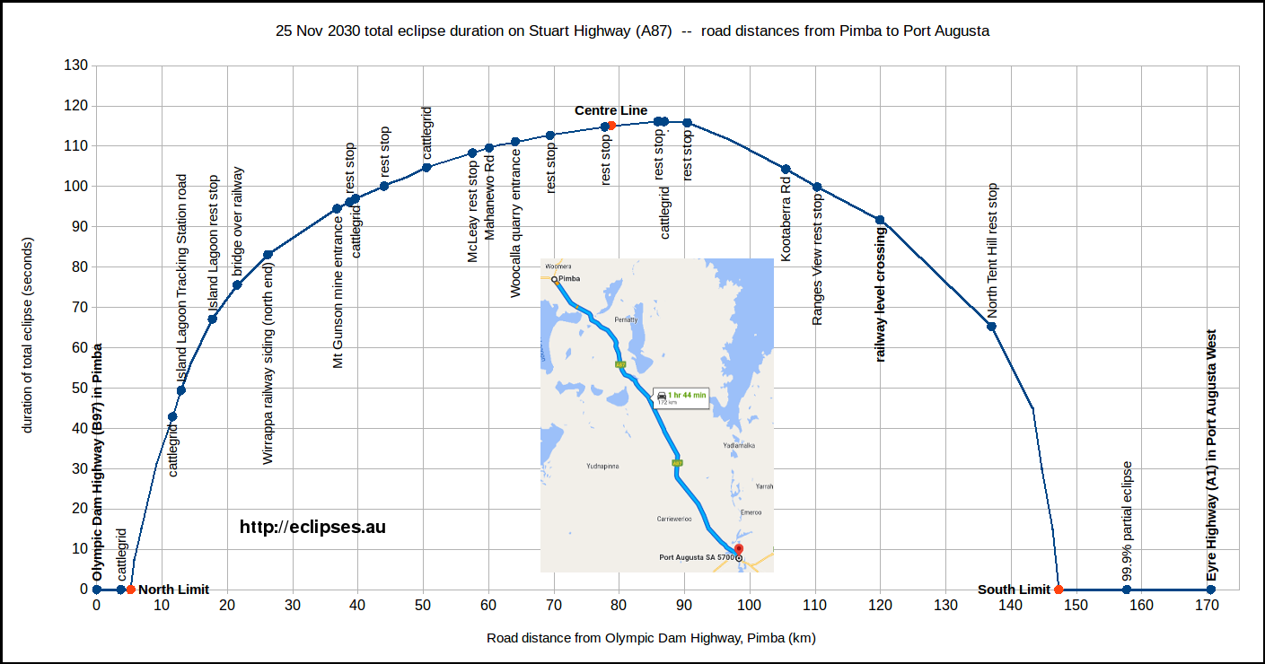
Total eclipse durations along some South Australian roads
These graphs plot driving distances in kilometres -vs- total eclipse durations along various public roads; to help you find a good viewing spot with no more than your car's trip meter. To help identify these roads a small Google Maps screenshot is included on each graph. For some of the main highways a pair of graphs is shown, for driving in either direction. A prominent landmark or major intersection is chosen to be "zero km".Click on the images for a bigger version. Also see the location photos below.
Flinders Highway (B100, see detail maps 01 and 02)
Driving northwest from Elliston through Streaky Bay to Ceduna
Driving southeast from Ceduna through Streaky Bay to Elliston
Eyre Highway (A1, see detail maps 01, 02, 03 and 04)
Driving west from Kimba through Poochera to Ceduna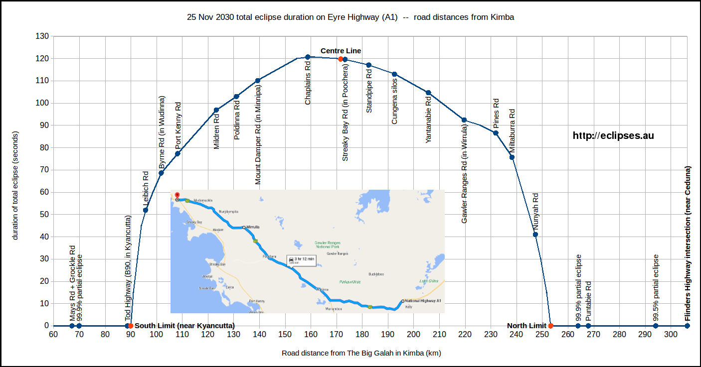
Driving east from Ceduna through Poochera to Kimba
Stuart Highway (A87, see detail maps 07 and 08)
Driving northwest from Port Augusta to Pimba and Woomera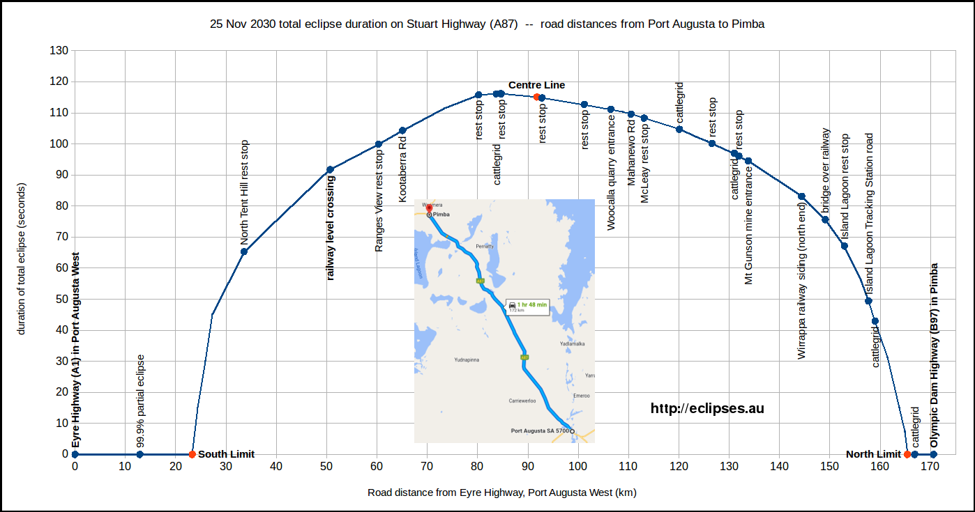
Driving southeast from Pimba to Port Augusta
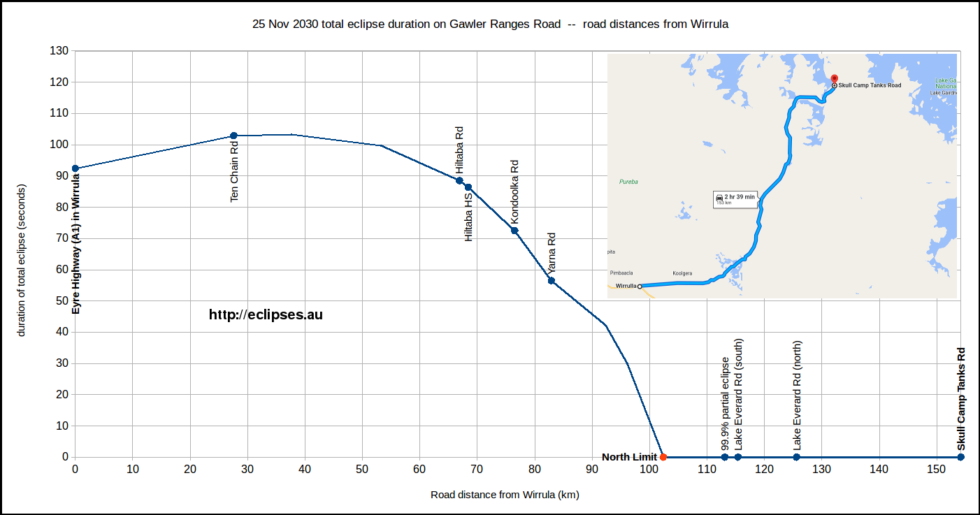
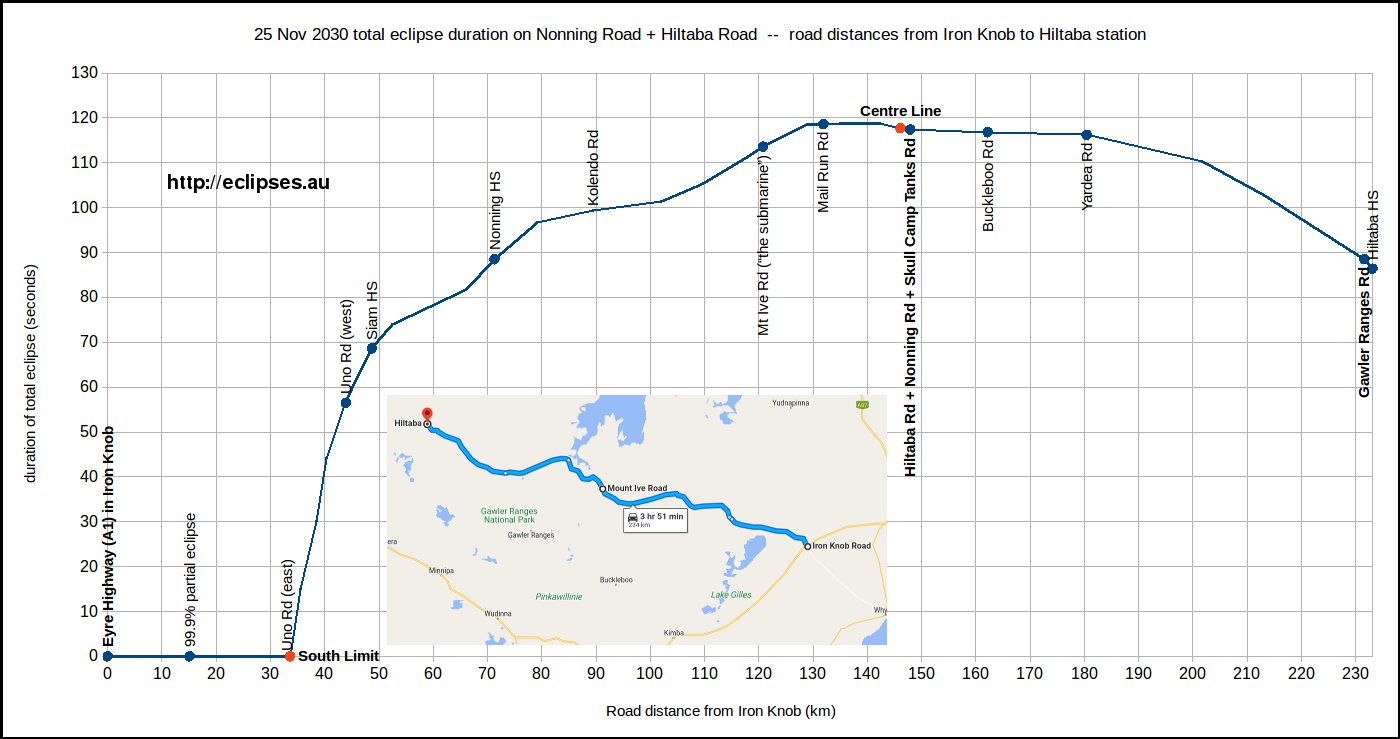
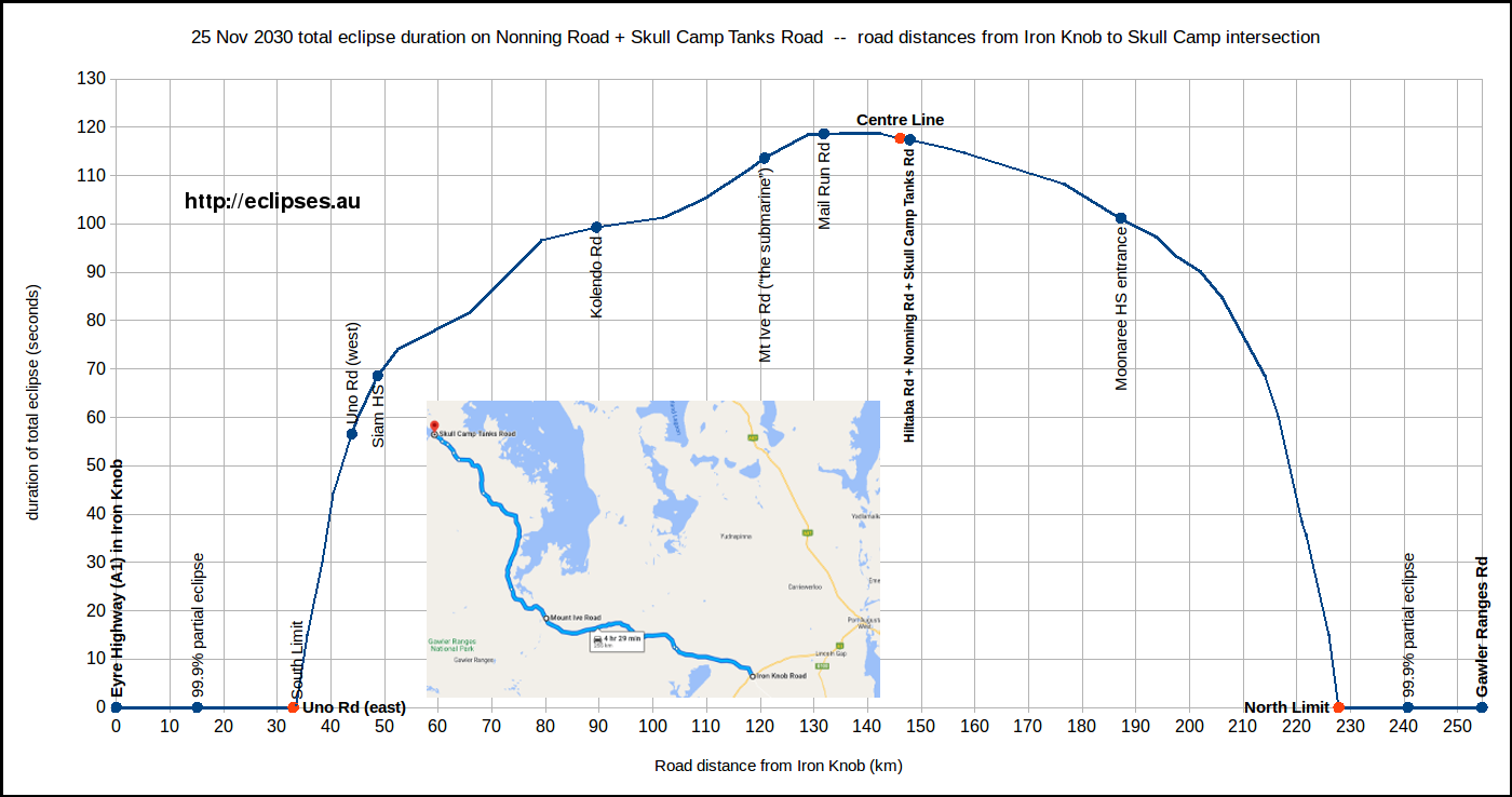
Roads in the Gawler Ranges (north of the Eyre Highway, see detail maps 05 and 06)
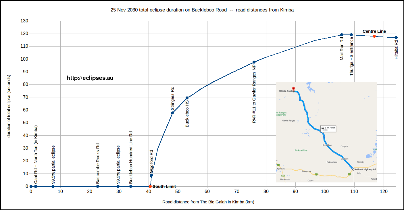
Check the weather forecasts and road conditions before travelling on these unsealed roads in the Gawler Ranges.Buckleboo Road, driving northwest from Kimba to the Hiltaba Road intersection
Gawler Ranges Road, driving northeast from Wirrula to Skull Camp Tanks intersection
Nonning Road + Hiltaba Road, driving west from Iron Knob to Hiltaba
Nonning Road + Skull Camp Tanks Road, driving west from Iron Knob to Skull Camp Tanks intersection
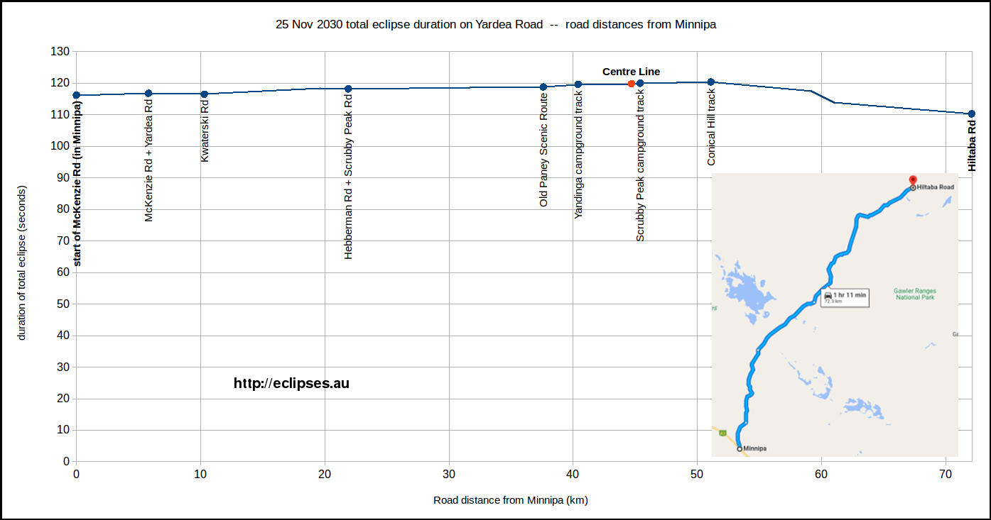
Yardea Road, driving northeast from Minnipa to the Hiltaba Road intersection
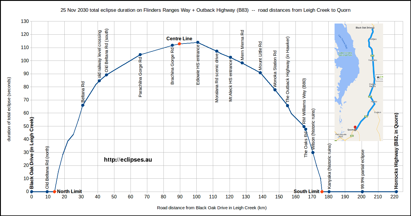
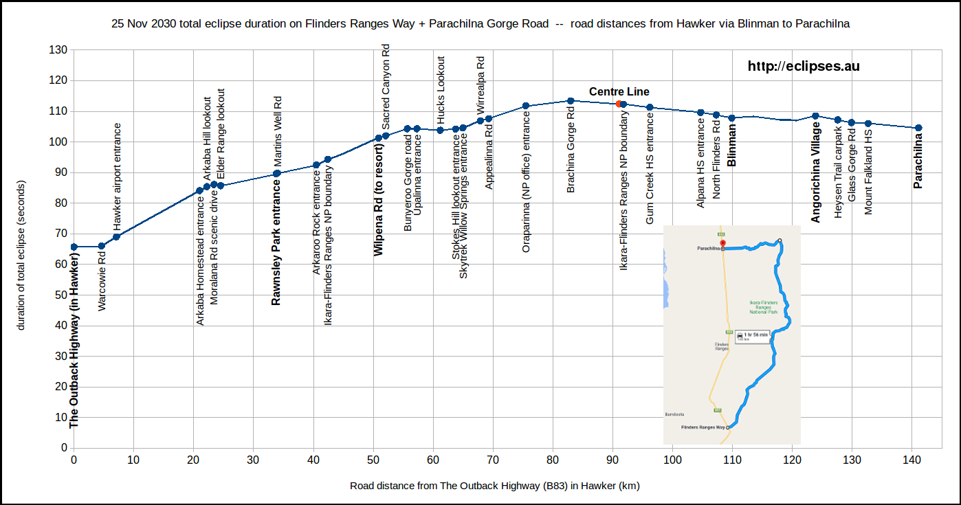
Roads in the Flinders Ranges (see detail maps 09, 10, 11 and 12)
Driving north from Quorn through Hawker and Parachilna to Leigh Creek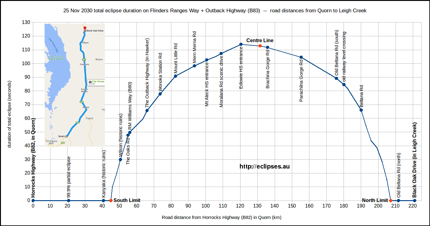
Driving south from Leigh Creek to Quorn
Driving north from Hawker to Blinman and then west to Parachilna
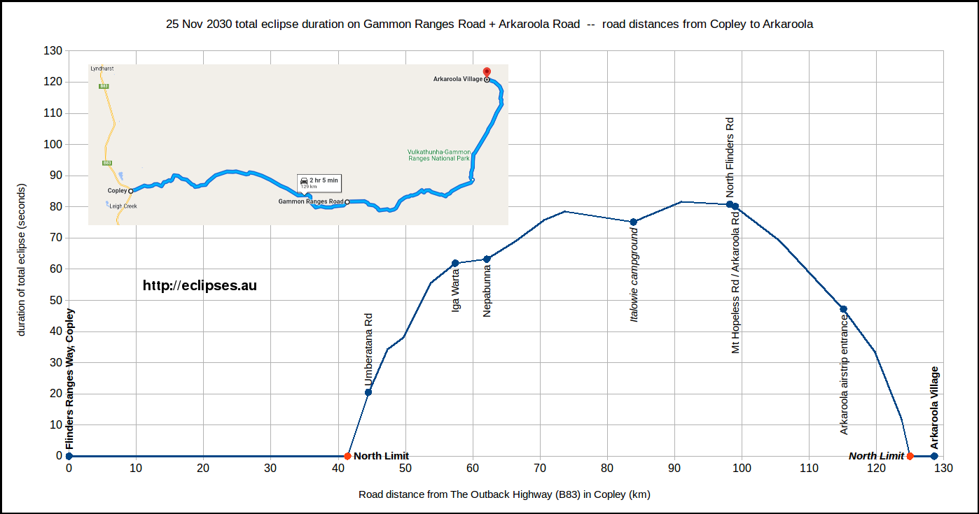
Driving east from Copley through Nepabunna to Arkaroola
Check the weather forecasts and road conditions before travelling on this unsealed road.
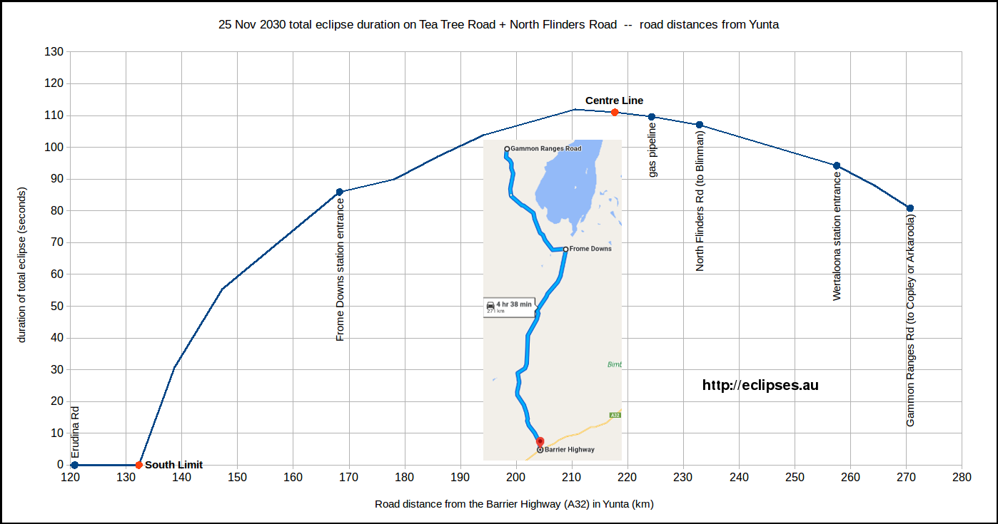
Driving north from Yunta to Gammon Ranges Road
Check the weather forecasts and road conditions before travelling on this unsealed road.
Photos from SA locations within (and near) the path of total eclipse
This section is a Work In Progress, which we're adding to as we travel through the locations and process the images...Panorama images are directed (approximately) towards the Sun's azimuth during total eclipse. Click on the images for a bigger version.
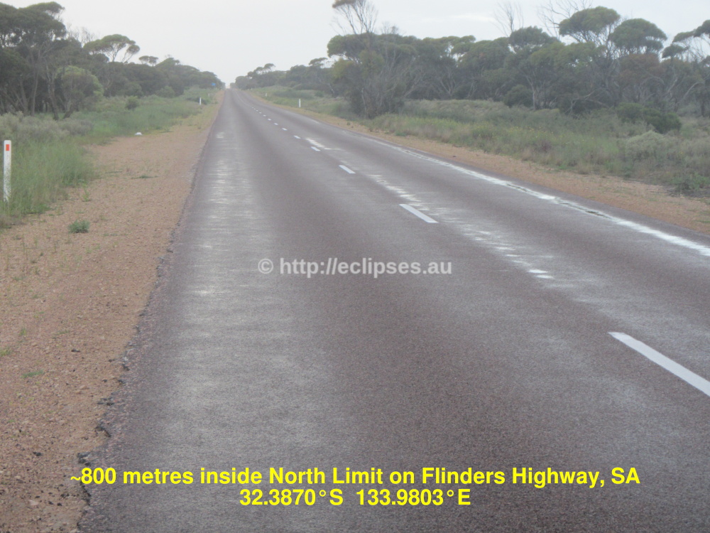
North Limit on Flinders Highway
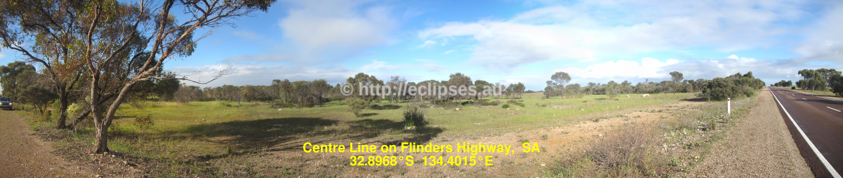
Centre Line panorama on Flinders Highway
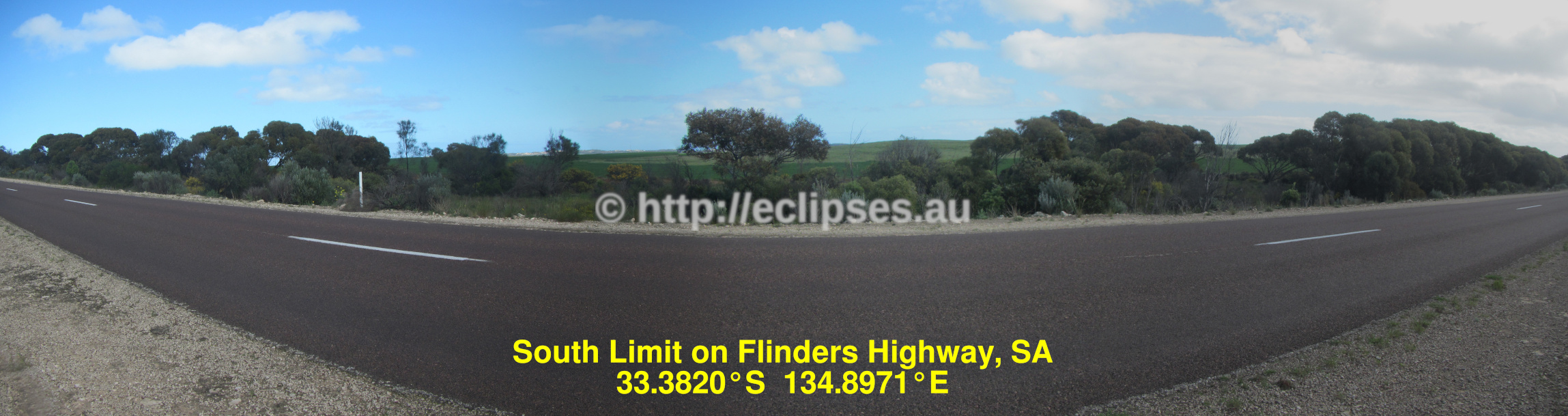
South Limit panorama on Flinders Highway
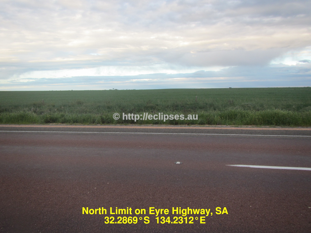
North Limit on Eyre Highway
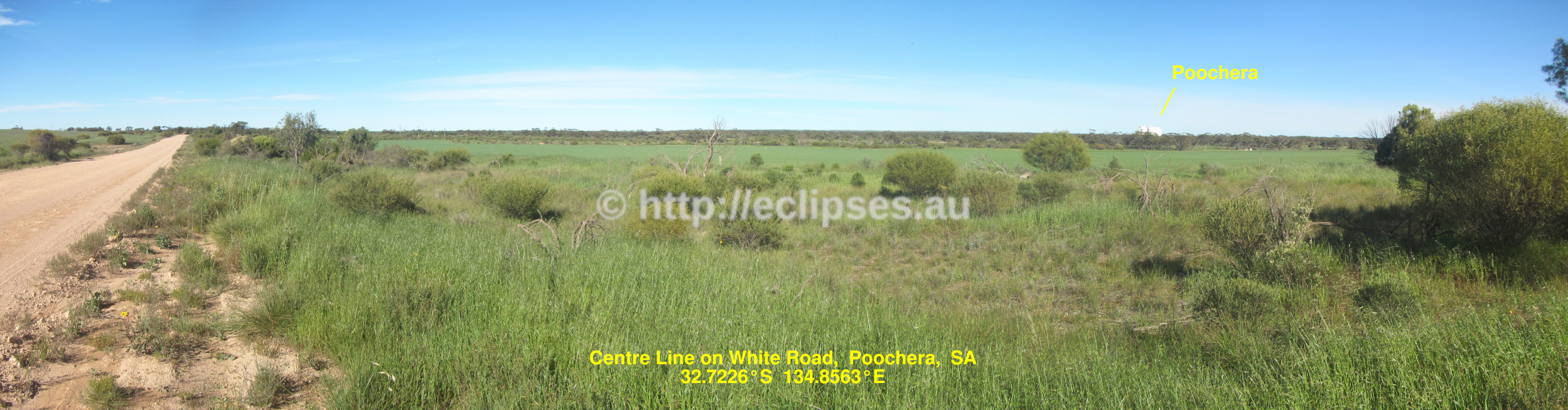
Centre Line near Poochera (on a roadside near Eyre Highway)
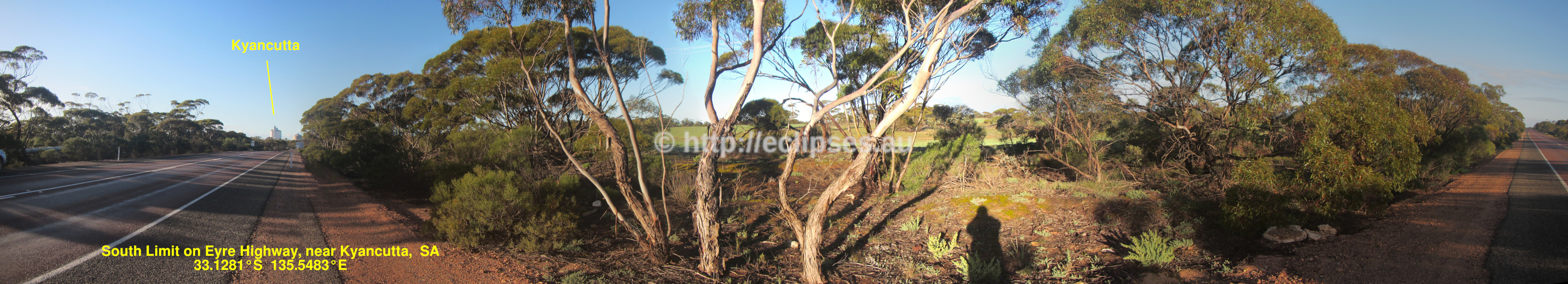
South Limit panorama on Eyre Highway (near Kyancutta)
Centre Line on Sceale Bay Road
Centre Line on Nonning Road
Panorama at intersection of Nonning + Hiltaba + Skull Camp Tank Roads (close to Centre Line)

Centre Line on Yardea Road
South Limit panorama on Stringers Road, near Buckleboo
North Limit panorama on Stuart Highway (near Pimba)
Panorama at Island Lagoon rest stop, Stuart Highway
Panorama at McLeay rest stop, Stuart Highway
Centre Line panorama on Stuart Highway
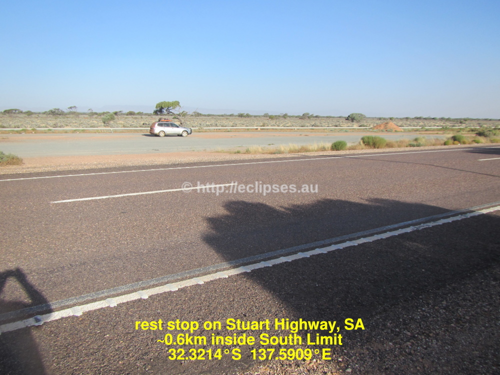
Rest stop just inside South Limit, Stuart Highway
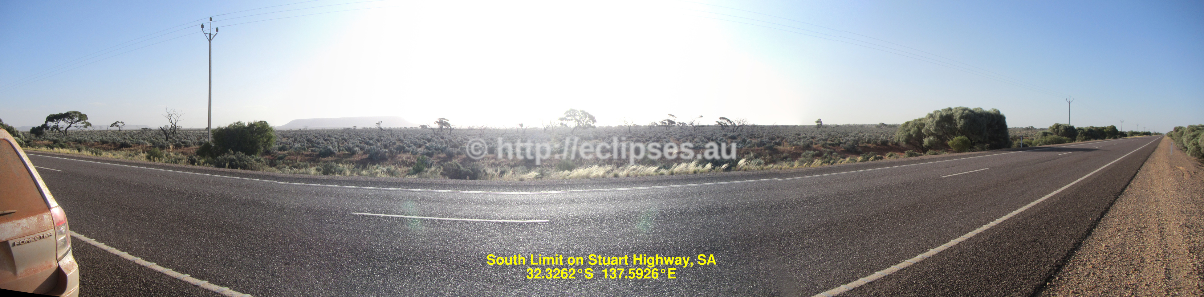
South Limit panorama on Stuart Highway
Weather for South Australia
7 day weather forecasts for South Australia, and for towns in/near total eclipse (Ceduna, Elliston, Hawker, Kimba, Leigh Creek, Port Augusta, Woomera, Wudinna).
Zoomable high resolution weather satellite images, cloud forecast maps and meteograms from Cloud Free Night and Skippy Sky.
|
(Scroll sideways if you're viewing this on a small screen) Skip to A B C -- Centre Line -- DEF -- GHI -- (road) intersections -- JKL -- MN -- North Limit -- OPQ -- RS -- South Limit -- TUV -- WXYZ |
||||||
| Location | South Australia local time (UT +10h30m on eclipse day) HH:MM:SS
All event times for total and nearly-total eclipses have been corrected for the moon's actual topography. |
|||||
| partial eclipse begins | total eclipse begins | total eclipse ends | maximum partial eclipse (if not total) |
maximum sun obscuration % (if partial) -- or -- total eclipse duration (mm:ss.s) |
partial eclipse ends | |
| Acraman campground | 17:53:05 | 18:51:37.7 | 18:53:30.7 | - | total 1m 53.0s | 19:46:46 |
| Adelaide (city centre) | 17:49:26 | none | none | 18:48:52 | 91.3 | 19:43:10 |
| Alawoona | 17:50:37 | none | none | 18:49:10 | 89.5 | 19:42:46 |
| Almerta station | 17:52:06 | almost | almost | 18:51:41 | 99.49 | 19:45:58 |
| Alpana station | 17:53:26 | 18:51:55.1 | 18:53:44.7 | - | total 1m 49.5s | 19:46:58 |
| Amata | 17:55:22 | none | none | 18:56:43 | 75.9 | 19:51:55 |
| Andamooka | 17:53:27 | none | none | 18:53:28 | 98.3 | 19:47:59 |
| Angepena station | 17:54:08 | 18:53:04.3 | 18:53:36.8 | - | total 32.5s | 19:47:26 |
| Angorichina station | 17:53:32 | 18:51:59.3 | 18:53:47.9 | - | total 1m 48.5s | 19:47:00 |
| Angorichina Village | 17:53:23 | 18:51:57.0 | 18:53:44.3 | - | total 1m 47.3s | 19:47:01 |
| Appealinna (historic ruins) | 17:53:08 | 18:51:40.2 | 18:53:27.2 | - | total 1m 47.0s | 19:46:42 |
| Arcoona campground | 17:54:20 | almost | almost | 18:53:34 | 99.97 | 19:47:30 |
| Arcoona station | 17:52:44 | almost | almost | 18:52:53 | 99.71 | 19:47:31 |
| Ardrossan | 17:49:34 | none | none | 18:49:22 | 93.75 | 19:43:56 |
| Argadells station | 17:52:02 | 18:51:32.6 | 18:51:48.1 | - | total 15.4s | 19:46:13 |
| Arkaroo Rock (carpark) | 17:52:55 | 18:51:37.4 | 18:53:10.9 | - | total 1m 33.5s | 19:46:33 |
| Arkaroola station | 17:54:38 | 18:53:31.7 | 18:53:38.7 | - | total 07.0s | 19:47:28 |
| Arkaroola Village | 17:54:38 | almost | almost | 18:53:43 | 99.99 | 19:47:30 |
| Arkaroola’s airstrip | 17:54:32 | 18:53:09.9 | 18:53:55.6 | - | total 45.8s | 19:47:25 |
| Arno Bay (jetty) | 17:49:19 | none | none | 18:49:46 | 96.97 | 19:44:49 |
| Aroona Hut campground | 17:53:14 | 18:51:45.4 | 18:53:38.0 | - | total 1m 52.6s | 19:46:52 |
| Auburn | 17:50:24 | none | none | 18:49:51 | 94.0 | 19:44:08 |
| Back Beach Road (end) | 17:49:01 | 18:49:38.7 | 18:51:32.1 | - | total 1m 53.5s | 19:46:29 |
| Baird Bay | 17:48:46 | 18:49:20.4 | 18:51:13.2 | - | total 1m 52.8s | 19:46:06 |
| Balaklava | 17:50:08 | none | none | 18:49:42 | 94.0 | 19:44:05 |
| Balcanoona (Vulkathunha-Gammon Ranges NP office) | 17:54:23 | 18:52:48.0 | 18:54:08.1 | - | total 1m 20.1s | 19:47:19 |
| Baratta station | 17:52:49 | almost | almost | 18:52:03 | 99.53 | 19:46:03 |
| Barmera | 17:51:04 | none | none | 18:49:41 | 91.1 | 19:43:19 |
| Bascombe Rocks | 17:50:07 | almost | almost | 18:50:44 | 99.8 | 19:45:50 |
| Beachport | 17:47:41 | none | none | 18:46:05 | 81.6 | 19:39:42 |
| Beltana station | 17:53:38 | 18:52:34.9 | 18:53:42.1 | - | total 1m 07.2s | 19:47:20 |
| Beltana Zinc mine (pit) | 17:53:49 | almost | almost | 18:53:19 | 99.99 | 19:47:27 |
| Bendleby Ranges station | 17:52:12 | none | none | 18:51:38 | 98.96 | 19:45:48 |
| Berri | 17:51:07 | none | none | 18:49:39 | 90.9 | 19:43:14 |
| Beverly (mine site) | 17:54:52 | almost | almost | 18:53:51 | 99.96 | 19:47:32 |
| Beverly mine entrance | 17:54:51 | 18:53:37.7 | 18:53:45.0 | - | total 07.3s | 19:47:29 |
| Bibliando station | 17:52:52 | almost | almost | 18:52:09 | 99.83 | 19:46:11 |
| Billeroo West station | 17:53:46 | almost | almost | 18:52:36 | 99.93 | 19:46:17 |
| Birdwood | 17:49:44 | none | none | 18:49:01 | 91.2 | 19:43:11 |
| Blanchetown | 17:50:33 | none | none | 18:49:33 | 91.87 | 19:43:29 |
| Blinman | 17:53:29 | 18:51:59.2 | 18:53:47.0 | - | total 1m 47.8s | 19:47:01 |
| Blinman airstrip | 17:53:29 | 18:51:57.1 | 18:53:46.5 | - | total 1m 49.4s | 19:46:59 |
| Booleroo Centre | 17:51:25 | none | none | 18:51:03 | 97.97 | 19:45:25 |
| Border Village ( *Eucla time zone*) | *16:01:37 | none | none | *17:05:32 | 92.2 | *18:03:04 |
| Bordertown | 17:49:13 | none | none | 18:47:26 | 84.3 | 19:40:52 |
| Bosworth station | 17:53:05 | almost | almost | 18:53:00 | 99.89 | 19:47:28 |
| Brachina East campground | 17:53:11 | 18:51:41.5 | 18:53:35.1 | - | total 1m 53.6s | 19:46:49 |
| Bramfield | 17:48:40 | almost | almost | 18:49:53 | 99.55 | 19:45:23 |
| Buckleboo (grain silos) | 17:50:10 | almost | almost | 18:50:49 | 99.97 | 19:45:56 |
| Buckleboo station | 17:50:13 | 18:50:19.3 | 18:51:28.8 | - | total 1m 09.5s | 19:46:05 |
| Bunyeroo Valley lookout | 17:53:07 | 18:51:38.3 | 18:53:31.2 | - | total 1m 52.9s | 19:46:46 |
| Burra | 17:50:53 | none | none | 18:50:14 | 94.8 | 19:44:25 |
| Cadney Park | 17:55:47 | none | none | 18:55:37 | 85.9 | 19:50:34 |
| Cambrian campground | 17:53:09 | 18:51:40.2 | 18:53:33.8 | - | total 1m 53.7s | 19:46:48 |
| Cameron Corner store (*Qld time zone*) | 17:26:43* | none | none | 18:24:57* | 98.35 | 19:16* (sunset) |
| Cape Borda lighthouse | 17:47:24 | none | none | 18:47:45 | 91.2 | 19:42:48 |
| Cape Du Couedic lighthouse | 17:47:10 | none | none | 18:47:25 | 90.1 | 19:42:25 |
| Cape Jervis lighthouse | 17:48:27 | none | none | 18:48:05 | 89.8 | 19:42:33 |
| Cape Slade | 17:48:45 | 18:49:18.7 | 18:51:20.9 | - | total 2m 02.2s | 19:46:13 |
| Carrapateena (mine camp) | 17:52:39 | 18:51:51.8 | 18:53:21.5 | - | total 1m 29.7s | 19:47:10 |
| Carrieton | 17:52:00 | almost | almost | 18:51:33 | 99.06 | 19:45:49 |
| Carriewerloo station | 17:51:20 | 18:51:00.6 | 18:51:56.6 | - | total 56.0s | 19:46:12 |
| Ceduna (jetty) | 17:49:29 | almost | almost | 18:51:16 | 99.3 | 19:47:12 |
| Ceduna Radio Observatory | 17:49:52 | none | none | 18:51:34 | 98.7 | 19:47:25 |
| Chambers Gorge campground | 17:53:54 | 18:52:07.9 | 18:53:57.2 | - | total 1m 49.3s | 19:46:58 |
| Clare | 17:50:33 | none | none | 18:50:03 | 94.7 | 19:44:21 |
| Cleve | 17:49:30 | none | none | 18:50:00 | 97.7 | 19:45:04 |
| Cockburn | 17:53:30 | none | none | 18:51:56 | 97.2 | 19:45:20 |
| Coffin Bay | 17:47:53 | none | none | 18:48:51 | 96.1 | 19:44:20 |
| Colton | 17:48:46 | almost | almost | 18:50:01 | 99.88 | 19:45:39 |
| Coober Pedy | 17:53:49 | none | none | 18:54:38 | 90.6 | 19:49:40 |
| Cook | 17:49:00 | none | none | 18:52:05 | 90.5 | 19:48:54 |
| Coomandook | 17:49:28 | none | none | 18:48:20 | 88.2 | 19:42:13 |
| Coonalpyn | 17:49:20 | none | none | 18:48:06 | 87.3 | 19:41:54 |
| Cooyerdoo station | 17:50:45 | almost | almost | 18:50:59 | 99.42 | 19:45:47 |
| Copley | 17:53:57 | almost | almost | 18:53:27 | 99.83 | 19:47:34 |
| Corraberra station | 17:51:27 | almost | almost | 18:51:27 | 99.85 | 19:46:02 |
| Corrobinnie Hill | 17:49:49 | 18:50:13.3 | 18:51:09.4 | - | total 56.1s | 19:45:59 |
| Corunna station | 17:50:58 | almost | almost | 18:51:10 | 99.76 | 19:45:56 |
| Cowell | 17:49:46 | none | none | 18:50:04 | 97.3 | 19:44:59 |
| Cradock | 17:52:21 | almost | almost | 18:51:54 | 99.89 | 19:46:09 |
| Crystal Brook | 17:50:51 | none | none | 18:50:33 | 96.73 | 19:44:58 |
| Cummins | 17:48:25 | none | none | 18:49:17 | 96.9 | 19:44:39 |
| Cungena (grain silos) | 17:49:38 | 18:49:58.8 | 18:51:51.8 | - | total 1m 53.0s | 19:46:35 |
| Curdimurka | 17:54:30 | none | none | 18:54:26 | 95.1 | 19:48:49 |
| Curnamona station | 17:53:18 | almost | almost | 18:52:22 | 99.9 | 19:46:14 |
| Centre Line on Brachina Gorge Road lat 31.3221° S long 138.4748° E |
17:53:08 | 18:51:42.3 | 18:53:35.1 | - | total 1m 52.8s | 19:46:52 |
| Centre Line on Buckleboo Road lat 32.3733° S long 135.7637° E |
17:50:31 | 18:50:19.7 | 18:52:17.6 | - | total 1m 57.9s | 19:46:34 |
| Centre Line on Eyre Highway (A1) lat 32.7241° S long 134.8521° E |
17:49:34 | 18:49:47.8 | 18:51:47.6 | - | total 1m 59.8s | 19:46:25 |
| Centre Line on Flinders Highway (B100) lat 32.8968° S long 134.4015° E |
17:49:05 | 18:49:31.7 | 18:51:32.5 | - | total 2m 00.7s | 19:46:20 |
| Centre Line on Flinders Ranges Way lat 31.2481° S long 138.6649° E |
17:53:19 | 18:51:47.6 | 18:53:40.0 | - | total 1m 52.4s | 19:46:52 |
| Centre Line on Lake Gairdner access track lat 32.2896° S long 135.9806° E |
17:50:44 | 18:50:26.8 | 18:52:24.3 | - | total 1m 57.5s | 19:46:36 |
| Centre Line on Nonning Road lat 32.3387° S long 135.8540° E |
17:50:32 | 18:50:22.7 | 18:52:20.5 | - | total 1m 57.7s | 19:46:35 |
| Centre Line on SA-NSW state border lat 30.3343° S long 141.0000° E |
17:55:18 | 18:52:44.6 | 18:54:32.8 | - | total 1m 48.1s | 19:46:56 |
| Centre Line on Sceale Bay Road lat 32.9672° S long 134.2170° E |
17:48:53 | 18:49:25.0 | 18:51:26.1 | - | total 2m 01.1s | 19:46:18 |
| Centre Line on Stuart Highway (A87) lat 31.7810° S long 137.2952° E |
17:52:02 | 18:51:08.0 | 18:53:03.1 | - | total 1m 55.1s | 19:46:46 |
| Centre Line on Tea Tree Road lat 30.9420° S long 139.4494° E |
17:54:00 | 18:52:07.7 | 18:53:58.7 | - | total 1m 51.0s | 19:46:55 |
| Centre Line on The Outback Highway (B83) lat 31.3449° S long 138.4165° E |
17:53:05 | 18:51:40.5 | 18:53:33.4 | - | total 1m 52.9s | 19:46:51 |
| Centre Line on Wirrealpa Road lat 31.1285° S long 138.9716° E |
17:53:35 | 18:51:55.6 | 18:53:47.5 | - | total 1m 51.9s | 19:46:54 |
| Centre Line on Yardea Road lat 32.5361° S long 135.3416° E |
17:50:05 | 18:50:05.2 | 18:52:03.9 | - | total 1m 58.8s | 19:46:30 |
| Darke Peak | 17:49:34 | none | none | 18:50:13 | 98.7 | 19:45:23 |
| Depot Springs station | 17:54:07 | almost | almost | 18:53:29 | 99.94 | 19:47:32 |
| Dingley Dell campground | 17:53:13 | 18:51:41.2 | 18:53:34.0 | - | total 1m 52.7s | 19:46:46 |
| Dublin | 17:49:47 | none | none | 18:49:22 | 93.1 | 19:43:46 |
| Eba Anchorage | 17:49:15 | 18:49:49.1 | 18:51:39.4 | - | total 1m 50.3s | 19:46:34 |
| Edeowie station | 17:53:00 | 18:51:34.8 | 18:53:28.4 | - | total 1m 53.6s | 19:46:45 |
| Edithburgh | 17:48:47 | none | none | 18:48:37 | 91.9 | 19:43:15 |
| Elliston | 17:48:33 | almost | almost | 18:49:50 | 99.58 | 19:45:29 |
| Erudina station | 17:53:25 | 18:51:57.3 | 18:53:06.6 | - | total 1m 09.3s | 19:46:27 |
| Eudunda | 17:50:28 | none | none | 18:49:43 | 93.1 | 19:43:51 |
| Farina bakery | 17:54:25 | none | none | 18:53:55 | 98.4 | 19:48:01 |
| Flinders Bush Retreat | 17:52:33 | 18:51:43.8 | 18:52:26.0 | - | total 42.2s | 19:46:18 |
| Flinders Island (airstrip) | 17:48:13 | almost | almost | 18:49:41 | 99.74 | 19:45:29 |
| Fowlers Bay | 17:48:48 | none | none | 18:51:09 | 97.5 | 19:47:30 |
| Frome Downs station | 17:53:51 | 18:52:06.6 | 18:53:32.4 | - | total 1m 25.9s | 19:46:34 |
| Gawler | 17:49:51 | none | none | 18:49:14 | 92.2 | 19:43:30 |
| Gilles Downs station | 17:50:42 | almost | almost | 18:50:57 | 99.47 | 19:45:47 |
| Gladstone | 17:51:01 | none | none | 18:50:39 | 96.8 | 19:45:01 |
| Glendambo | 17:52:05 | none | none | 18:52:48 | 98.2 | 19:47:52 |
| Goolwa | 17:48:57 | none | none | 18:48:15 | 89.3 | 19:42:28 |
| Grindells Hut campground | 17:54:24 | 18:53:01.6 | 18:53:57.1 | - | total 55.5s | 19:47:24 |
| Gum Creek station | 17:53:22 | 18:51:51.2 | 18:53:42.3 | - | total 1m 51.1s | 19:46:55 |
| Hallett | 17:51:09 | none | none | 18:50:32 | 95.7 | 19:44:43 |
| Haslam (jetty) | 17:49:23 | 18:50:10.2 | 18:51:41.2 | - | total 1m 31.0s | 19:46:45 |
| Hawker | 17:52:30 | 18:51:31.4 | 18:52:37.1 | - | total 1m 05.7s | 19:46:21 |
| Hawker airport | 17:52:34 | 18:51:32.9 | 18:52:41.6 | - | total 1m 08.7s | 19:46:23 |
| Hiltaba station (accommodation) | 17:50:21 | 18:50:43.1 | 18:52:10.6 | - | total 1m 27.5s | 19:46:55 |
| Holowilena South station | 17:52:38 | almost | almost | 18:52:02 | 99.85 | 19:46:10 |
| Holowilena station | 17:52:43 | almost | almost | 18:52:08 | 99.98 | 19:46:14 |
| Hucks lookout, Flinders Ranges Way | 17:53:05 | 18:51:39.9 | 18:53:23.8 | - | total 1m 43.8s | 19:46:40 |
| Iga Warta | 17:54:09 | 18:52:51.9 | 18:53:53.0 | - | total 1m 01.0s | 19:47:23 |
| Illeroo station | 17:51:19 | almost | almost | 18:51:23 | 99.89 | 19:46:03 |
| Innamincka | 17:57:59 | none | none | 18:56:07 | 94.0 | 19:45:00 |
| Iron Duke (mine site) | 17:50:19 | none | none | 18:50:32 | 98.2 | 19:45:22 |
| Iron Knob | 17:50:55 | almost | almost | 18:51:07 | 99.65 | 19:45:53 |
| Island Lagoon lookout, Stuart Highway (A87) | 17:52:17 | 18:51:55.0 | 18:53:02.1 | - | total 1m 07.1s | 19:47:14 |
| Italowie campground | 17:54:18 | 18:52:48.2 | 18:54:04.3 | - | total 1m 15.1s **HIDDEN by local terrain** | 19:47:20 |
| If you can't find "intersection [Road A] + [Road B]" try looking for "intersection [Road B] + [Road A]". | ||||||
| intersection Armstrongs Road + Lindquist Road | 17:49:46 | 18:50:08.9 | 18:51:56.1 | - | total 1m 47.2s | 19:46:41 |
| intersection Barns Road + Best Road | 17:49:47 | 18:49:58.1 | 18:51:36.7 | - | total 1m 38.6s | 19:46:10 |
| intersection Bascombe Rocks Road + Stringers Road | 17:50:00 | almost | almost | 18:50:42 | 99.93 | 19:45:53 |
| intersection Birdseye Highway (B91) + Rocky Valley Road | 17:48:53 | almost | almost | 18:50:02 | 99.69 | 19:45:35 |
| intersection Buckleboo Road + Hiltaba Road | 17:50:30 | 18:50:21.2 | 18:52:18.0 | - | total 1m 56.8s | 19:46:36 |
| intersection Buckleboo Road + Mail Run Road | 17:50:27 | 18:50:15.4 | 18:52:14.6 | - | total 1m 59.1s | 19:46:29 |
| intersection Buckleboo Road + PAR #11 | 17:50:15 | 18:50:13.4 | 18:51:51.0 | - | total 1m 37.6s | 19:46:14 |
| intersection Buckleboo Road + Stringers Road | 17:50:11 | 18:50:23.6 | 18:51:21.4 | - | total 57.7s | 19:46:02 |
| intersection Buckleboo Stock Road + Allen Road | 17:49:41 | 18:50:15.2 | 18:50:45.2 | - | total 35.0s | 19:45:55 |
| intersection Bunyeroo Road + Old Blinman Road | 17:53:06 | 18:51:38.6 | 18:53:27.3 | - | total 1m 48.7s | 19:46:43 |
| intersection Calca Road + Baird Bay Road | 17:48:54 | 18:49:23.3 | 18:51:25.0 | - | total 2m 01.7s | 19:46:13 |
| intersection Calca Road + Point Labatt Road | 17:48:50 | 18:49:21.3 | 18:51:23.4 | - | total 2m 02.1s | 19:46:14 |
| intersection Carawa Road + Hammat Road | 17:49:31 | 18:50:26.4 | 18:51:37.4 | - | total 1m 11.0s | 19:46:50 |
| intersection Chaplains Road + Crabb Road | 17:49:31 | 18:49:43.2 | 18:51:41.0 | - | total 1m 57.8s | 19:46:17 |
| intersection Chilpenunda Road + Gerscwhitz Road | 17:49:28 | 18:49:56.1 | 18:51:46.5 | - | total 1m 50.4s | 19:46:36 |
| intersection Deverell Road + Lockes Claypan Road | 17:49:48 | 18:50:01.5 | 18:51:57.0 | - | total 1m 55.5s | 19:46:34 |
| intersection Dog Fence Road + Roberts Road | 17:49:34 | 18:50:06.6 | 18:51:49.5 | - | total 1m 43.0s | 19:46:42 |
| intersection Eyre Highway (A1) + Carawa Road | 17:49:40 | almost | almost | 18:51:12 | 99.99 | 19:46:58 |
| intersection Eyre Highway (A1) + Howard Road | 17:49:37 | 18:50:23.7 | 18:51:45.9 | - | total 1m 22.2s | 19:46:50 |
| intersection Eyre Highway (A1) + Leibich Road | 17:49:34 | 18:50:07.1 | 18:50:59.1 | - | total 52.0s | 19:45:55 |
| intersection Eyre Highway (A1) + Nunyah Road | 17:49:39 | 18:50:43.3 | 18:51:24.4 | - | total 41.0s | 19:46:55 |
| intersection Eyre Highway (A1) + Poldinna Road | 17:49:34 | 18:49:49.8 | 18:51:32.9 | - | total 1m 43.0s | 19:46:10 |
| intersection Eyre Highway (A1) + Standpipe Road | 17:49:35 | 18:49:53.0 | 18:51:50.1 | - | total 1m 57.1s | 19:46:30 |
| intersection Eyre Highway (A1) + Stiggants Road | 17:49:38 | almost | almost | 18:50:30 | 99.91 | 19:45:49 |
| intersection Eyre Highway (A1) + Stringers Road | 17:49:43 | almost | almost | 18:50:29 | 99.68 | 19:45:43 |
| intersection Eyre Highway (A1) + Tod Highway (B90), in Kyancutta | 17:49:33 | almost | almost | 18:50:30 | 99.99 | 19:45:52 |
| intersection Flinders Highway (B100) + Baird Bay Road | 17:49:05 | 18:49:32.0 | 18:51:32.5 | - | total 2m 00.5s | 19:46:20 |
| intersection Flinders Highway (B100) + Carawa Road | 17:49:25 | 18:50:12.8 | 18:51:41.3 | - | total 1m 28.5s | 19:46:46 |
| intersection Flinders Highway (B100) + Finlayson Road | 17:49:22 | 18:50:01.6 | 18:51:41.2 | - | total 1m 41.6s | 19:46:40 |
| intersection Flinders Highway (B100) + Karkara Tank Road | 17:49:26 | 18:50:24.3 | 18:51:33.8 | - | total 1m 09.5s | 19:46:50 |
| intersection Flinders Highway (B100) + Mt Damper Road | 17:48:55 | 18:49:43.1 | 18:50:40.1 | - | total 57.0s | 19:45:49 |
| intersection Flinders Highway (B100) + Smoky Bay Road | 17:49:23 | almost | almost | 18:51:03 | 99.99 | 19:46:55 |
| intersection Flinders Highway (B100) + Talia Caves Road | 17:48:55 | 18:49:36.0 | 18:50:46.9 | - | total 1m 10.9s | 19:45:52 |
| intersection Flinders Highway (B100) + Warna Well Road | 17:48:52 | 18:49:52.2 | 18:50:02.3 | - | total 10.1s | 19:45:45 |
| intersection Flinders Highway (B100) + Woorong Boolong Road | 17:48:59 | 18:49:28.3 | 18:51:17.8 | - | total 1m 49.5s | 19:46:06 |
| intersection Flinders Highway (B100) + Yandra Road | 17:49:03 | 18:49:28.4 | 18:51:30.2 | - | total 2m 01.7s | 19:46:15 |
| intersection Flinders Ranges Way (B83) + RM Williams Way (B80) | 17:52:25 | 18:51:36.8 | 18:52:26.5 | - | total 49.7s | 19:46:18 |
| intersection Flinders Ranges Way (B83) + Simmonston Road | 17:52:03 | almost | almost | 18:51:46 | 99.91 | 19:46:08 |
| intersection Flinders Ranges Way + Arkaroo Rock Road | 17:52:55 | 18:51:37.9 | 18:53:10.4 | - | total 1m 32.5s | 19:46:33 |
| intersection Flinders Ranges Way + Brachina Gorge Road | 17:53:15 | 18:51:43.4 | 18:53:36.9 | - | total 1m 53.4s | 19:46:49 |
| intersection Flinders Ranges Way + Bunyeroo Road | 17:53:03 | 18:51:38.4 | 18:53:22.8 | - | total 1m 44.3s | 19:46:40 |
| intersection Flinders Ranges Way + Moralana Gorge Road | 17:52:45 | 18:51:34.3 | 18:53:00.4 | - | total 1m 26.1s | 19:46:29 |
| intersection Flinders Ranges Way + North Flinders Road | 17:53:29 | 18:51:57.4 | 18:53:46.2 | - | total 1m 48.8s | 19:47:00 |
| intersection Flinders Ranges Way + Old Blinman Road | 17:53:10 | 18:51:40.7 | 18:53:29.0 | - | total 1m 48.3s | 19:46:43 |
| intersection Flinders Ranges Way + Wilpena Road | 17:53:00 | 18:51:37.9 | 18:53:19.2 | - | total 1m 41.3s | 19:46:38 |
| intersection Flinders Ranges Way + Wirrealpa Road | 17:53:09 | 18:51:40.8 | 18:53:27.7 | - | total 1m 46.9s | 19:46:42 |
| intersection Gammon Ranges Road + Maynards Well Road | 17:54:03 | almost | almost | 18:53:28 | 99.94 | 19:47:31 |
| intersection Gawler Ranges Rd + Yarna Rd | 17:50:30 | 18:51:04.5 | 18:52:01.0 | - | total 56.5s | 19:47:01 |
| intersection Gawler Ranges Road + Hiltaba Road | 17:50:20 | 18:50:42.0 | 18:52:10.5 | - | total 1m 28.5s | 19:46:54 |
| intersection Gawler Ranges Road + Kondoolka Road | 17:50:25 | 18:50:55.0 | 18:52:07.5 | - | total 1m 12.5s | 19:46:59 |
| intersection Gawler Ranges Road + Priests Road | 17:49:52 | 18:50:18.3 | 18:51:58.6 | - | total 1m 40.3s | 19:46:46 |
| intersection Gawler Ranges Road + Wallpuppie Road | 17:49:47 | 18:50:18.8 | 18:51:55.1 | - | total 1m 36.3s | 19:46:47 |
| intersection Gawler Ranges Road + Yantanabie Road | 17:49:56 | 18:50:17.8 | 18:52:00.8 | - | total 1m 43.1s | 19:46:45 |
| intersection Inkster Road + Tootla Road | 17:49:19 | 18:49:37.9 | 18:51:39.0 | - | total 2m 01.2s | 19:46:20 |
| intersection Karger Road + Scholz Road | 17:49:46 | 18:49:54.0 | 18:51:43.3 | - | total 1m 49.2s | 19:46:15 |
| intersection Kyancutta Mount Wedge Road + Cocata Hill Road | 17:49:20 | almost | almost | 18:50:22 | 99.97 | 19:45:48 |
| intersection Lake (Frome) Track + gas pipeline | 17:54:25 | 18:52:35.1 | 18:54:11.9 | - | total 1m 36.8s | 19:47:11 |
| intersection McEvoy Road + Blackhill Road | 17:49:29 | 18:49:52.0 | 18:51:47.1 | - | total 1m 55.1s | 19:46:32 |
| intersection Miltaburra Road + Murraminga Road | 17:49:31 | 18:50:36.0 | 18:51:25.2 | - | total 49.2s | 19:46:53 |
| intersection Moralana Gorge Road + Black Gap Road | 17:52:52 | 18:51:34.0 | 18:53:13.6 | - | total 1m 39.6s | 19:46:36 |
| intersection Mount Damper Rd + Cocata Hill Road | 17:49:11 | 18:49:45.4 | 18:50:56.2 | - | total 1m 10.8s | 19:45:55 |
| intersection Mount Damper Road + McMahon Road | 17:49:15 | 18:49:44.6 | 18:51:07.0 | - | total 1m 22.5s | 19:45:59 |
| intersection Mount Hopeless Road + Pipeline Road | 17:55:11 | almost | almost | 18:54:01 | 99.79 | 19:47:37 |
| intersection Nonning Road + Hiltaba Road + Skull Camp Tanks Road | 17:50:37 | 18:50:23.5 | 18:52:20.9 | - | total 1m 57.4s | 19:46:36 |
| intersection Nonning Road + Kolendo Road | 17:50:43 | 18:50:27.8 | 18:52:07.1 | - | total 1m 39.3s | 19:46:19 |
| intersection Nonning Road + Uno Road (east) | 17:50:51 | almost | almost | - | 99.99 | 19:46:04 |
| intersection Nonning Road + Uno Road (west) | 17:50:50 | 18:50:45.2 | 18:51:41.7 | - | total 56.5s | 19:46:08 |
| intersection North Flinders Road + Gammon Ranges Road | 17:54:22 | 18:52:47.4 | 18:54:08.2 | - | total 1m 20.8s | 19:47:19 |
| intersection North Flinders Road + Mulga View Road | 17:53:55 | 18:52:10.8 | 18:53:58.1 | - | total 1m 47.3s | 19:47:02 |
| intersection North Flinders Road + Nantawarrina Road | 17:53:48 | 18:52:06.1 | 18:53:55.0 | - | total 1m 48.9s | 19:46:59 |
| intersection North Flinders Road + Narrina Road | 17:53:32 | 18:51:59.0 | 18:53:48.0 | - | total 1m 49.0s | 19:47:00 |
| intersection Nungi Road + Bennie Road | 17:49:44 | 18:50:24.8 | 18:51:50.7 | - | total 1m 25.8s | 19:46:50 |
| intersection Nungi Road + Pearson Road | 17:49:45 | 18:50:34.3 | 18:51:45.1 | - | total 1m 10.8s | 19:46:53 |
| intersection Old Hookina Road + Bobby Creek Road + Neuroodla Road | 17:52:31 | 18:51:26.6 | 18:52:55.8 | - | total 1m 29.2s | 19:46:29 |
| intersection Parawilia Gorge Road + Glen Lyle Road | 17:52:40 | 18:51:34.7 | 18:52:49.0 | - | total 1m 13.3s | 19:46:25 |
| intersection Partacoona Road + Bobby Creek Road | 17:52:14 | 18:51:30.6 | 18:52:22.6 | - | total 52.0s | 19:46:17 |
| intersection Point Brown Road + Shell Pit Road | 17:49:21 | 18:50:36.1 | 18:51:10.8 | - | total 34.7s | 19:46:52 |
| intersection Poochera Port Kenny Road + Cooblee Road | 17:49:12 | 18:49:34.3 | 18:51:27.9 | - | total 1m 53.6s | 19:46:11 |
| intersection Port Kenny Road + Mount Damper Road | 17:49:22 | 18:49:43.7 | 18:51:24.1 | - | total 1m 40.5s | 19:46:06 |
| intersection Port Kenny Road + Talia Road | 17:49:28 | 18:49:50.7 | 18:51:19.6 | - | total 1m 29.0s | 19:46:03 |
| intersection Princes Road + Murtyle Rocks Road | 17:49:45 | 18:49:51.8 | 18:51:52.2 | - | total 2m 00.4s | 19:46:23 |
| intersection Pygery Port Kenny Road + Colley Road | 17:49:05 | 18:49:33.8 | 18:51:17.1 | - | total 1m 43.3s | 19:46:04 |
| intersection Rohrlach Road + Jacks Hill Rd | 17:49:18 | almost | almost | 18:50:16 | 99.74 | 19:45:41 |
| intersection Sceale Bay Road + Westall Way Loop | 17:48:58 | 18:49:31.9 | 18:51:30.2 | - | total 1m 58.3s | 19:46:24 |
| intersection Schmucker Road + Cocata Hill Road | 17:49:15 | 18:49:57.7 | 18:50:47.6 | - | total 50.0s | 19:45:52 |
| intersection Schmucker Road + Diamond Valley Road | 17:49:05 | almost | almost | 18:50:13 | 99.96 | 19:45:45 |
| intersection Standpipe Road + Murraminga Road | 17:49:35 | almost | almost | 18:51:10 | 99.99 | 19:46:58 |
| intersection Streaky Bay Road + Chilpenunda Road | 17:49:15 | 18:49:44.3 | 18:51:40.0 | - | total 1m 55.7s | 19:46:29 |
| intersection Streaky Bay Road + Standpipe Road | 17:49:23 | 18:49:44.1 | 18:51:42.8 | - | total 1m 58.7s | 19:46:26 |
| intersection Stuart Highway (A87) + Kootaberra Rd | 17:51:52 | 18:51:02.3 | 18:52:46.6 | - | total 1m 44.3s | 19:46:32 |
| intersection Stuart Highway (A87) + Mahanewo Rd | 17:52:05 | 18:51:17.0 | 18:53:06.6 | - | total 1m 49.7s | 19:46:54 |
| intersection Tarragon Tanks Road + Oswald Road | 17:49:21 | 18:49:46.7 | 18:51:14.0 | - | total 1m 27.3s | 19:46:01 |
| intersection Tea Tree Road + Erudina Road | 17:53:22 | almost | almost | 18:52:25 | 99.96 | 19:46:16 |
| intersection Tea Tree Road + Erudina Woolshed Road | 17:53:41 | 18:52:06.1 | 18:53:11.3 | - | total 1m 05.2s | 19:46:26 |
| intersection Tea Tree Road + gas pipeline | 17:54:01 | 18:52:10.4 | 18:54:00.0 | - | total 1m 49.6s | 19:46:58 |
| intersection Tea Tree Road + North Flinders Road | 17:54:03 | 18:52:14.9 | 18:54:02.0 | - | total 1m 47.1s | 19:47:02 |
| intersection Ten Chain Road + Pearson Road | 17:49:52 | 18:50:31.2 | 18:51:54.0 | - | total 1m 22.8s | 19:46:52 |
| intersection The Outback Highway (B83) + Beltana Road | 17:53:35 | 18:52:34.4 | 18:53:40.0 | - | total 1m 05.6s | 19:47:20 |
| intersection The Outback Highway (B83) + Brachina Gorge Rd | 17:53:08 | 18:51:43.3 | 18:53:35.1 | - | total 1m 51.8s | 19:46:54 |
| intersection The Outback Highway (B83) + Moralana Gorge Road | 17:52:53 | 18:51:32.2 | 18:53:19.5 | - | total 1m 47.3s | 19:46:40 |
| intersection The Outback Highway (B83) + Old Beltana Road (north) | 17:53:49 | almost | almost | 18:53:19 | 99.99 | 19:47:28 |
| intersection The Outback Highway (B83) + Old Beltana Road (south) | 17:53:29 | 18:52:16.4 | 18:53:45.6 | - | total 1m 29.2s | 19:47:14 |
| intersection The Outback Highway (B83) + Three Sisters Road | 17:52:36 | 18:51:28.6 | 18:53:00.4 | - | total 1m 31.7s | 19:46:30 |
| intersection Ucontichie Road + McMahon Road | 17:49:19 | 18:49:50.2 | 18:50:58.3 | - | total 1m 08.1s | 19:45:55 |
| intersection Ucontichie Road + Simpson Road | 17:49:27 | 18:49:53.7 | 18:51:04.2 | - | total 1m 10.5s | 19:45:57 |
| intersection Warcowie Road + Nantabra Well Road | 17:52:52 | 18:51:55.6 | 18:52:21.8 | - | total 26.2s | 19:46:19 |
| intersection Wirrealpa Road + Erudina Road | 17:53:23 | 18:51:47.7 | 18:53:33.2 | - | total 1m 45.5s | 19:46:42 |
| intersection Wirrealpa Road + Oraparinna Road | 17:53:13 | 18:51:41.7 | 18:53:31.6 | - | total 1m 49.9s | 19:46:44 |
| intersection Wirrealpa Road + Wilkawillina Road | 17:53:20 | 18:51:44.9 | 18:53:36.8 | - | total 1m 51.9s | 19:46:46 |
| intersection Yandra Road + Witera Road | 17:49:07 | 18:49:30.0 | 18:51:30.5 | - | total 2m 00.5s | 19:46:14 |
| Jacinth-Ambrosia (mine camp) | 17:49:56 | none | none | 18:52:15 | 93.7 | 19:48:31 |
| Jamestown | 17:51:12 | none | none | 18:50:43 | 96.7 | 19:45:00 |
| Kadina | 17:49:56 | none | none | 18:49:51 | 95.4 | 19:44:29 |
| Kallioota station | 17:52:18 | 18:51:16.6 | 18:52:58.1 | - | total 1m 41.5s | 19:46:33 |
| Kangaroo Well station | 17:51:08 | 18:51:44.3 | 18:51:58.8 | - | total 14.5s | 19:47:10 |
| Kanyaka (historic ruins) | 17:52:15 | almost | almost | 18:51:53 | 99.99 | 19:46:13 |
| Kapunda | 17:50:12 | none | none | 18:49:32 | 92.8 | 19:43:43 |
| Karcultaby School | 17:49:36 | 18:49:46.9 | 18:51:47.6 | - | total 2m 00.7s | 19:46:22 |
| Karoonda | 17:49:57 | none | none | 18:48:45 | 89.2 | 19:42:35 |
| Keith | 17:49:12 | none | none | 18:47:40 | 85.5 | 19:41:16 |
| Kimba | 17:50:04 | almost | almost | 18:50:36 | 99.36 | 19:45:40 |
| Kingoonya | 17:51:54 | none | none | 18:52:48 | 97.6 | 19:48:00 |
| Kingscote | 17:48:08 | none | none | 18:47:59 | 90.2 | 19:42:38 |
| Kingston on Murray | 17:51:03 | none | none | 18:49:43 | 91.4 | 19:43:23 |
| Kingston SE | 17:48:14 | none | none | 18:46:49 | 83.8 | 19:40:34 |
| Kokatha station (entrance) | 17:51:27 | none | none | 18:52:26 | 98.56 | 19:47:42 |
| Kolendo station | 17:50:47 | 18:50:27.6 | 18:52:14.7 | - | total 1m 47.2s | 19:46:24 |
| Kondoolka station | 17:50:24 | almost | almost | 18:51:37 | 99.97 | 19:47:07 |
| Koolamon campground | 17:53:14 | 18:51:44.1 | 18:53:37.0 | - | total 1m 52.9s | 19:46:51 |
| Kooma View station | 17:49:41 | almost | almost | 18:50:31 | 99.86 | 19:45:48 |
| Koonamore station | 17:52:47 | almost | almost | 18:51:57 | 99.12 | 19:45:54 |
| Koonibba | 17:49:34 | none | none | 18:51:27 | 98.41 | 19:47:27 |
| Kootaberra station | 17:51:54 | 18:51:02.7 | 18:52:48.7 | - | total 1m 46.1s | 19:46:33 |
| Kyancutta | 17:49:33 | almost | almost | 18:50:30 | 99.99 | 19:45:52 |
| Lake Everard station | 17:50:52 | almost | almost | 18:51:55 | 99.72 | 19:47:17 |
| Lake Gairdner carpark (via Mt Ive station) | 17:50:48 | 18:50:32.2 | 18:52:27.6 | - | total 1m 55.4s | 19:46:40 |
| Lake Torrens station | 17:52:35 | 18:51:21.8 | 18:53:14.3 | - | total 1m 52.5s | 19:46:41 |
| Lameroo | 17:50:02 | none | none | 18:48:31 | 87.7 | 19:42:06 |
| Leigh Creek | 17:53:54 | almost | almost | 18:53:24 | 99.88 | 19:47:32 |
| Lock | 17:49:12 | none | none | 18:50:03 | 98.9 | 19:45:23 |
| Loxton | 17:50:55 | none | none | 18:49:28 | 90.3 | 19:43:03 |
| Lucindale | 17:48:22 | none | none | 18:46:41 | 82.8 | 19:40:13 |
| Lyndhurst | 17:54:12 | almost | almost | 18:53:42 | 99.1 | 19:47:49 |
| Mahanewo station | 17:51:38 | 18:51:16.0 | 18:52:52.3 | - | total 1m 36.3s | 19:47:01 |
| Maitland | 17:49:29 | none | none | 18:49:24 | 94.2 | 19:44:03 |
| Mallala | 17:49:24 | none | none | 18:49:24 | 92.97 | 19:43:44 |
| Mangalo (grain silos) | 17:49:45 | none | none | 18:50:12 | 98.1 | 19:45:13 |
| Manna Hill | 17:52:41 | none | none | 18:51:35 | 97.4 | 19:45:21 |
| Manners Well station | 17:54:01 | 18:53:04.1 | 18:53:29.5 | - | total 25.4s | 19:47:26 |
| Mannum | 17:49:50 | none | none | 18:48:56 | 90.47 | 19:42:58 |
| Marion Bay | 17:48:10 | none | none | 18:48:22 | 92.3 | 19:43:16 |
| Marla | 17:55:18 | none | none | 18:56:07 | 83.2 | 19:51:02 |
| Marree | 17:54:47 | none | none | 18:54:19 | 96.9 | 19:48:25 |
| Martins Well station | 17:53:17 | 18:51:50.1 | 18:53:17.5 | - | total 1m 27.4s | 19:46:32 |
| McLaren Vale | 17:49:06 | none | none | 18:48:33 | 90.47 | 19:42:52 |
| McLeay railway siding (south end) | 17:52:06 | 18:51:17.9 | 18:53:06.9 | - | total 1m 49.0s | 19:46:55 |
| McLeay rest stop, Stuart Highway (A87) | 17:52:06 | 18:51:19.0 | 18:53:10.2 | - | total 1m 48.3s | 19:46:56 |
| Melrose | 17:51:23 | none | none | 18:51:06 | 98.3 | 19:45:31 |
| Meningie | 17:49:04 | none | none | 18:48:04 | 88.0 | 19:42:05 |
| Mern Merna station | 17:52:43 | 18:51:29.5 | 18:53:10.4 | - | total 1m 41.0s | 19:46:36 |
| Merna Mora station | 17:52:51 | 18:51:31.3 | 18:53:19.9 | - | total 1m 48.6s | 19:46:41 |
| Milang | 17:49:09 | none | none | 18:48:22 | 89.3 | 19:42:31 |
| Millicent | 17:47:46 | none | none | 18:45:59 | 80.89 | 19:39:27 |
| Miltaburra School | 17:49:37 | 18:50:28.6 | 18:51:42.0 | - | total 1m 13.4s | 19:46:51 |
| Minlaton | 17:49:01 | none | none | 18:48:57 | 93.0 | 19:43:38 |
| Minnipa | 17:49:36 | 18:49:48.8 | 18:51:39.1 | - | total 1m 50.3s | 19:46:14 |
| Moolawatana station | 17:55:15 | almost | almost | 18:54:06 | 99.52 | 19:47:43 |
| Moolooloo station | 17:53:33 | 18:52:08.8 | 18:53:48.6 | - | total 1m 39.8s | 19:47:08 |
| Moomba (gas plant) | 17:57:23 | none | none | 18:55:48 | 94.6 | 19:47:00 |
| Moonaree station | 17:51:02 | 18:50:55.9 | 18:52:35.0 | - | total 1m 39.2s | 19:46:56 |
| Moonta Bay | 17:49:45 | none | none | 18:49:44 | 95.3 | 19:44:25 |
| Moorilla station | 17:53:36 | 18:52:22.2 | 18:53:48.1 | - | total 1m 25.9s | 19:47:16 |
| Morgan | 17:50:54 | none | none | 18:49:54 | 92.8 | 19:43:49 |
| Motpena station | 17:53:11 | 18:51:53.0 | 18:53:38.3 | - | total 1m 45.3s | 19:47:02 |
| Mount Aleck station | 17:52:47 | 18:51:31.0 | 18:53:13.6 | - | total 1m 42.6s | 19:46:37 |
| Mount Arden station | 17:51:35 | almost | almost | 18:51:33 | 99.97 | 19:46:07 |
| Mount Barker | 17:49:26 | none | none | 18:48:44 | 90.5 | 19:42:56 |
| Mount Camel Beach (carpark) | 17:48:52 | 18:49:33.4 | 18:50:50.1 | - | total 1m 16.7s | 19:45:53 |
| Mount Falkland station | 17:53:21 | 18:51:57.2 | 18:53:43.2 | - | total 1m 46.0s | 19:47:02 |
| Mount Fitton mine | 17:55:07 | almost | almost | 18:54:06 | 99.26 | 19:47:48 |
| Mount Gambier | 17:47:47 | none | none | 18:45:44 | 79.7 | 19:39:01 |
| Mount Gunson (mine camp) | 17:52:21 | 18:51:39.5 | 18:53:13.4 | - | total 1m 33.9s | 19:47:07 |
| Mount Ive station | 17:50:37 | 18:50:20.6 | 18:52:14.5 | - | total 1m 53.9s | 19:46:26 |
| Mount Saint Mungo (summit) | 17:50:32 | 18:50:47.3 | 18:52:17.1 | - | total 1m 29.8s | 19:46:56 |
| Mount Serle station | 17:54:10 | 18:53:12.5 | 18:53:31.2 | - | total 18.7s | 19:47:27 |
| Mount Wudinna (summit) | 17:49:42 | 18:50:01.9 | 18:51:15.1 | - | total 1m 13.3s | 19:46:01 |
| Mulga View station | 17:53:57 | 18:52:14.9 | 18:53:59.4 | - | total 1m 44.5s | 19:47:05 |
| Mungerannie | 17:56:53 | none | none | 18:55:53 | 92.3 | 19:49:31 |
| Murphy’s Haystacks | 17:49:00 | 18:49:26.0 | 18:51:25.7 | - | total 1m 59.7s | 19:46:12 |
| Murray Bridge | 17:49:36 | none | none | 18:48:42 | 89.9 | 19:42:45 |
| Myrtle Springs station | 17:53:58 | almost | almost | 18:53:32 | 99.42 | 19:47:43 |
| Nantawarrina station | 17:53:56 | 18:52:21.3 | 18:53:59.2 | - | total 1m 37.9s | 19:47:10 |
| Naracoorte | 17:48:35 | none | none | 18:46:43 | 82.4 | 19:40:06 |
| Narcoona station | 17:51:50 | almost | almost | 18:51:41 | 99.99 | 19:46:11 |
| Narrina station | 17:53:46 | 18:52:10.8 | 18:53:54.4 | - | total 1m 43.7s | 19:47:06 |
| Nepabunna Adata Madapa | 17:54:11 | 18:52:52.5 | 18:53:54.6 | - | total 1m 02.1s | 19:47:22 |
| Nilpena station | 17:53:22 | 18:52:12.3 | 18:53:41.9 | - | total 1m 29.6s | 19:47:13 |
| Nonning Road + Mail Run Road intersection | 17:50:35 | 18:50:19.1 | 18:52:17.7 | - | total 1m 58.6s | 19:46:29 |
| Nonning station | 17:50:47 | 18:50:33.0 | 18:52:01.5 | - | total 1m 28.5s | 19:46:15 |
| Normanville (jetty) | 17:48:44 | none | none | 18:48:16 | 90.0 | 19:42:41 |
| North Moolooloo station | 17:53:55 | almost | almost | 18:53:23 | 99.98 | 19:47:29 |
| North Tent Hill rest stop, Stuart Highway (A87) | 17:51:40 | 18:51:05.8 | 18:52:11.1 | - | total 1m 05.3s | 19:46:15 |
| Nuccaleena Mine (historic ruins) | 17:53:33 | 18:52:13.8 | 18:53:48.9 | - | total 1m 35.1s | 19:47:11 |
| Nudlamutana Hut | 17:54:34 | 18:53:16.3 | 18:53:48.2 | - | total 32.0s | 19:47:26 |
| Nullarbor (roadhouse) | 17:48:20 | none | none | 18:51:20 | 93.9 | 19:48:09 |
| Nundroo | 17:48:53 | none | none | 18:51:18 | 96.7 | 19:47:43 |
| Nunjikompita (grain silos) | 17:49:45 | 18:50:56.5 | 18:51:17.4 | - | total 20.8s | 19:46:57 |
| Nuriootpa | 17:50:07 | none | none | 18:49:24 | 92.3 | 19:43:34 |
| Nurrungar Joint Defence Facility (near Pimba) | 17:52:15 | 18:52:24.3 | 18:52:29.9 | - | total 05.6s | 19:47:19 |
| Nuttbush Retreat (Pandurra station) | 17:51:11 | almost | almost | 18:51:15 | 99.63 | 19:45:55 |
| North Limit on Arkaroola Road lat 30.3255° S long 139.3673° E |
17:54:38 | 18:53:41.7 | 18:53:41.7 | - | north limit **HIDDEN by local terrain** | 19:47:29 |
| North Limit on Carawa Road lat 32.2940° S long 134.2125° E |
17:49:38 | 18:51:10.9 | 18:51:10.9 | - | north limit | 19:46:57 |
| North Limit on Eyre Highway (A1) lat 32.2869° S long 134.2312° E |
17:49:39 | 18:51:11.5 | 18:51:11.5 | - | north limit | 19:46:57 |
| North Limit on Flinders Highway (B100) lat 32.3845° S long 133.9730° E |
17:49:23 | 18:51:02.5 | 18:51:02.5 | - | north limit | 19:46:55 |
| North Limit on Gammon Ranges Road lat 30.5431° S long 138.7985° E |
17:54:09 | 18:53:28.2 | 18:53:28.2 | - | north limit | 19:47:28 |
| North Limit on Gawler Ranges Road lat 31.9127° S long 135.2193° E |
17:50:42 | 18:51:44.9 | 18:51:44.9 | - | north limit | 19:47:07 |
| North Limit on Kondookla Road lat 32.0413° S long 134.8823° E |
17:50:21 | 18:51:33.8 | 18:51:33.8 | - | north limit | 19:47:04 |
| North Limit on Maynards Well Road lat 30.5946° S long 138.6651° E |
17:54:02 | 18:53:24.8 | 18:53:24.8 | - | north limit | 19:47:28 |
| North Limit on Miltaburra Road lat 32.3747° S long 133.9990° E |
17:49:24 | 18:51:03.3 | 18:51:03.3 | - | north limit | 19:46:55 |
| North Limit on Mount Hopeless Road lat 30.2074° S long 139.6777° E |
17:54:54 | 18:53:48.7 | 18:53:48.7 | - | north limit | 19:47:29 |
| North Limit on Murraminga Road lat 32.3173° S long 134.1508° E |
17:49:34 | 18:51:08.7 | 18:51:08.7 | - | north limit | 19:46:57 |
| North Limit on Nungi Road lat 32.2595° S long 134.3037° E |
17:49:44 | 18:51:14.0 | 18:51:14.0 | - | north limit | 19:46:58 |
| North Limit on Nunyah Road lat 32.2377° S long 134.3615° E |
17:49:48 | 18:51:16.1 | 18:51:16.1 | - | north limit | 19:46:59 |
| North Limit on Old Beltana Road lat 30.6982° S long 138.3986° E |
17:53:47 | 18:53:18.0 | 18:53:18.0 | - | north limit | 19:47:27 |
| North Limit on SA-NSW state border lat 29.6970° S long 141.0000° E |
17:55:59 | 18:54:17.1 | 18:54:17.1 | - | north limit | 19:47 (sunset) |
| North Limit on Saw Tooth Road lat 32.3055° S long 134.1819° E |
17:49:36 | 18:51:09.8 | 18:51:09.8 | - | north limit | 19:46:57 |
| North Limit on Shell Pit Road lat 32.3922° S long 133.9527° E |
17:49:21 | 18:51:01.7 | 18:51:01.7 | - | north limit | 19:46:54 |
| North Limit on Skull Camp Tanks Road lat 31.7556° S long 135.6323° E |
17:51:08 | 18:51:58.3 | 18:51:58.3 | - | north limit | 19:47:11 |
| North Limit on Stuart Highway (A87) lat 31.2959° S long 136.8370° E |
17:52:19 | 18:52:35.0 | 18:52:35.0 | - | north limit | 19:47:19 |
| North Limit on The Outback Highway (B83) lat 30.7065° S long 138.3769° E |
17:53:46 | 18:53:11.3 | 18:53:11.3 | - | north limit | 19:47:27 |
| North Limit on Umberatana Road lat 30.4803° S long 138.9614° E |
17:54:17 | 18:53:32.3 | 18:53:32.3 | - | north limit | 19:47:29 |
| Oakden Hills station | 17:52:02 | 18:51:17.7 | 18:53:04.9 | - | total 1m 47.2s | 19:46:56 |
| Oakden Hills station (Old) | 17:52:13 | 18:51:35.3 | 18:53:09.6 | - | total 1m 34.3s | 19:47:06 |
| Olary | 17:53:00 | none | none | 18:51:44 | 97.4 | 19:45:23 |
| Old Paney station | 17:50:05 | 18:50:02.8 | 18:52:02.7 | - | total 1m 59.8s | 19:46:26 |
| Olympic Dam (mine plant) | 17:53:17 | none | none | 18:53:27 | 97.9 | 19:48:04 |
| Oodnadatta | 17:55:58 | none | none | 18:56:08 | 86.4 | 19:50:35 |
| Operation Flinders (Owieandana Yankaninna) | 17:54:19 | almost | almost | 18:53:34 | 99.98 | 19:47:31 |
| Oraparinna mine (entrance) | 17:53:20 | 18:51:44.9 | 18:53:35.2 | - | total 1m 50.2s | 19:46:45 |
| Oraparinna station (Ikara-Flinders Ranges NP office) | 17:53:13 | 18:51:41.3 | 18:53:33.1 | - | total 1m 51.8s | 19:46:45 |
| Oratunga station | 17:53:30 | 18:52:01.9 | 18:53:47.5 | - | total 1m 45.7s | 19:47:03 |
| Orroroo | 17:51:42 | none | none | 18:51:13 | 98.1 | 19:45:29 |
| Padthaway | 17:48:47 | none | none | 18:47:06 | 83.76 | 19:40:37 |
| Paney station (Gawler Ranges NP office) | 17:50:07 | 18:50:05.4 | 18:51:56.0 | - | total 1m 50.6s | 19:46:20 |
| Parachilna | 17:53:18 | 18:51:57.0 | 18:53:41.6 | - | total 1m 44.6s | 19:47:03 |
| Paskeville | 17:49:57 | none | none | 18:49:47 | 94.98 | 19:44:21 |
| Peculiar Knob (mine site) | 17:53:29 | none | none | 18:54:09 | 93.3 | 19:49:06 |
| Penola | 17:48:14 | none | none | 18:46:15 | 80.96 | 19:39:33 |
| Penong | 17:49:16 | none | none | 18:51:20 | 98.0 | 19:47:29 |
| Perlubie Beach (north end) | 17:49:16 | 18:49:51.4 | 18:51:40.4 | - | total 1m 49.0s | 19:46:35 |
| Pernatty station | 17:52:28 | 18:51:31.5 | 18:53:17.5 | - | total 1m 46.0s | 19:46:59 |
| Peterborough | 17:51:34 | none | none | 18:50:59 | 97.1 | 19:45:10 |
| Petina | 17:49:33 | 18:50:12.0 | 18:51:47.3 | - | total 1m 35.4s | 19:46:45 |
| Pildappa Rock | 17:49:46 | 18:49:52.3 | 18:51:48.7 | - | total 1m 56.4s | 19:46:19 |
| Pimba | 17:52:21 | almost | almost | 18:52:37 | 99.96 | 19:47:22 |
| Pinnaroo | 17:50:18 | none | none | 18:48:36 | 87.4 | 19:42:02 |
| Pipalyatjara | 17:54:03 | none | none | 18:56:10 | 73.4 | 19:51:55 |
| Point Brown Road (end) | 17:49:08 | 18:50:16.1 | 18:51:22.3 | - | total 1m 06.2s | 19:46:47 |
| Point Labatt | 17:48:42 | 18:49:16.9 | 18:51:12.9 | - | total 1m 56.0s | 19:46:06 |
| Poochera | 17:49:33 | 18:49:48.1 | 18:51:47.7 | - | total 1m 59.6s | 19:46:25 |
| Port Augusta | 17:51:31 | almost | almost | 18:51:25 | 99.63 | 19:45:57 |
| Port Broughton | 17:50:26 | none | none | 18:50:15 | 96.3 | 19:44:48 |
| Port Germein | 17:51:05 | none | none | 18:50:53 | 97.97 | 19:45:22 |
| Port Julia | 17:49:18 | none | none | 18:49:06 | 93.0 | 19:43:41 |
| Port Kenny | 17:48:57 | 18:49:31.0 | 18:51:09.7 | - | total 1m 38.7s | 19:46:01 |
| Port Lincoln | 17:48:01 | none | none | 18:48:48 | 95.3 | 19:44:08 |
| Port Neill | 17:48:58 | none | none | 18:49:32 | 96.6 | 19:44:40 |
| Port Pirie | 17:50:54 | none | none | 18:50:42 | 97.5 | 19:45:12 |
| Port Victoria | 17:49:14 | none | none | 18:49:15 | 94.05 | 19:43:58 |
| Port Wakefield | 17:49:56 | none | none | 18:49:39 | 94.2 | 19:44:07 |
| Portia (mine camp) | 17:53:56 | almost | almost | 18:52:36 | 99.6 | 19:46:08 |
| Proby’s Grave (historic site) | 17:52:07 | 18:51:29.7 | 18:52:16.6 | - | total 46.9s | 19:46:16 |
| Prominent Hill (mine camp) | 17:53:25 | none | none | 18:54:03 | 93.9 | 19:48:58 |
| Pugilist Hill lookout | 17:52:52 | 18:51:38.6 | 18:53:03.9 | - | total 1m 25.3s | 19:46:29 |
| Puttapa station | 17:53:43 | 18:52:34.3 | 18:53:47.3 | - | total 1m 13.0s | 19:47:20 |
| Pygery | 17:49:35 | 18:49:56.6 | 18:51:13.9 | - | total 1m 17.3s | 19:46:00 |
| Quinyambie station | 17:54:44 | 18:52:35.8 | 18:53:39.9 | - | total 1m 04.1s | 19:46:28 |
| Quinyambie station (Old) | 17:55:26 | 18:52:53.2 | 18:54:37.7 | - | total 1m 44.5s | 19:47:03 |
| Quorn | 17:51:49 | almost | almost | 18:51:36 | 99.72 | 19:46:02 |
| railway level crossing, Stuart Highway (A87) | 17:51:46 | 18:51:02.3 | 18:52:34.0 | - | total 1m 31.7s | 19:46:24 |
| Ranges View rest stop, Stuart Highway (A87) | 17:51:50 | 18:51:02.8 | 18:52:42.7 | - | total 1m 39.9s | 19:46:29 |
| Raukkan | 17:49:08 | none | none | 18:48:16 | 88.8 | 19:42:21 |
| Rawnsley Park (Station Hill lookout) | 17:52:51 | 18:51:35.9 | 18:53:08.5 | - | total 1m 32.6s | 19:46:32 |
| Redhill | 17:50:39 | none | none | 18:50:21 | 96.1 | 19:44:47 |
| Renmark | 17:51:17 | none | none | 18:49:46 | 91.0 | 19:43:18 |
| Robe | 17:47:52 | none | none | 18:46:26 | 82.9 | 19:40:11 |
| Roxby Downs | 17:53:11 | none | none | 18:53:20 | 98.3 | 19:47:57 |
| Rudall | 17:49:23 | none | none | 18:49:59 | 98.0 | 19:45:08 |
| Saddleworth | 17:50:24 | none | none | 18:49:48 | 93.7 | 19:44:02 |
| Salt Creek (Coorong) | 17:48:48 | none | none | 18:47:36 | 86.3 | 19:41:28 |
| Sceale Bay | 17:48:48 | 18:49:21.0 | 18:51:23.1 | - | total 2m 02.1s | 19:46:15 |
| Scrubby Peak campground | 17:50:05 | 18:50:05.8 | 18:52:04.4 | - | total 1m 58.6s | 19:46:31 |
| Scrubby Peak station | 17:49:54 | 18:49:58.3 | 18:51:58.0 | - | total 1m 59.7s | 19:46:28 |
| Shaggy Ridge station | 17:52:47 | 18:51:40.5 | 18:52:43.7 | - | total 1m 03.2s | 19:46:22 |
| Sheringa | 17:48:34 | none | none | 18:49:40 | 98.7 | 19:45:12 |
| Siam station (entrance) | 17:50:52 | 18:50:40.1 | 18:51:48.7 | - | total 1m 08.6s | 19:46:10 |
| Skull Camp Tanks | 17:51:10 | almost | almost | 18:52:05 | 99.67 | 19:47:21 |
| Skytrek Willow Springs | 17:53:09 | 18:51:41.5 | 18:53:25.1 | - | total 1m 43.6s | 19:46:40 |
| Smoky Bay (jetty) | 17:49:21 | almost | almost | 18:51:02 | 99.99 | 19:46:55 |
| Smooth Pools | 17:48:50 | 18:49:27.5 | 18:51:26.1 | - | total 1m 58.6s | 19:46:22 |
| Snaglee Rock trig point | 17:49:15 | 18:49:38.3 | 18:51:24.0 | - | total 1m 45.8s | 19:46:07 |
| Snowtown | 17:50:24 | none | none | 18:50:05 | 95.4 | 19:44:32 |
| South Gap station | 17:52:22 | 18:51:19.2 | 18:53:13.1 | - | total 1m 53.9s | 19:46:49 |
| Spalding | 17:50:54 | none | none | 18:50:25 | 95.8 | 19:44:42 |
| Stansbury | 17:48:59 | none | none | 18:48:49 | 92.36 | 19:43:25 |
| Stirling North | 17:51:32 | almost | almost | 18:51:24 | 99.52 | 19:45:55 |
| Stockport observatory | 17:50:06 | none | none | 18:49:32 | 93.0 | 19:43:47 |
| Stokes Hill lookout, Flinders Ranges Way | 17:53:08 | 18:51:41.0 | 18:53:24.6 | - | total 1m 43.6s | 19:46:40 |
| Strathalbyn | 17:49:16 | none | none | 18:48:32 | 89.9 | 19:42:43 |
| Streaky Bay | 17:49:04 | 18:49:38.7 | 18:51:33.8 | - | total 1m 55.2s | 19:46:28 |
| Streaky Bay airport | 17:49:04 | 18:49:35.4 | 18:51:33.6 | - | total 1m 58.2s | 19:46:25 |
| Stuart Highway (A87) at SA-NT state border | 17:56:45 | none | none | 18:57:16 | 78.1 | 19:51:51 |
| Stuart Highway (A87), Woocalla quarry entrance | 17:52:05 | 18:51:15.3 | 18:53:06.4 | - | total 1m 51.1s | 19:46:53 |
| Swan Reach | 17:50:19 | none | none | 18:49:19 | 91.2 | 19:43:15 |
| South Limit on Arden Vale Road lat 32.1486° S long 138.0430° E |
17:52:01 | 18:51:47.5 | 18:51:47.5 | - | south limit | 19:46:12 |
| South Limit on Buckleboo Road lat 32.9060° S long 136.1135° E |
17:50:08 | 18:50:49.1 | 18:50:49.1 | - | south limit | 19:45:58 |
| South Limit on Carriewerloo Road lat 32.4362° S long 137.3118° E |
17:51:20 | 18:51:26.6 | 18:51:26.6 | - | south limit | 19:46:08 |
| South Limit on Cocata Hill Road lat 33.2218° S long 135.3081° E |
17:49:18 | 18:50:21.8 | 18:50:21.8 | - | south limit | 19:45:50 |
| South Limit on Cradock Road lat 31.9658° S long 138.5015° E |
17:52:28 | 18:52:01.0 | 18:52:01.0 | - | south limit | 19:46:16 |
| South Limit on Erudina Road lat 31.5493° S long 139.5565° E |
17:53:25 | 18:52:28.5 | 18:52:28.5 | - | south limit | 19:46:20 |
| South Limit on Eyre Highway (A1) lat 33.1281° S long 135.5483° E |
17:49:33 | 18:50:29.9 | 18:50:29.9 | - | south limit | 19:45:52 |
| South Limit on Flinders Highway (B100) lat 33.3820° S long 134.8971° E |
17:48:51 | 18:50:07.5 | 18:50:07.5 | - | south limit | 19:45:45 |
| South Limit on Flinders Ranges Way (B83) lat 32.0385° S long 138.3185° E |
17:52:18 | 18:51:56.0 | 18:51:56.0 | - | south limit | 19:46:15 |
| South Limit on Natabra Well Road lat 31.8055° S long 138.9047° E |
17:52:50 | 18:52:12.0 | 18:52:12.0 | - | south limit | 19:46:18 |
| South Limit on Nonning Road lat 32.6268° S long 136.8261° E |
17:50:51 | 18:51:11.7 | 18:51:11.7 | - | south limit | 19:46:04 |
| South Limit on RM Williams Way (B80) lat 32.0011° S long 138.4126° E |
17:52:23 | 18:51:58.6 | 18:51:58.6 | - | south limit | 19:46:15 |
| South Limit on SA-NSW state border lat 30.9754° S long 141.0000° E |
17:54:38 | 18:53:02.6 | 18:53:02.6 | - | south limit | 19:46:22 |
| South Limit on Schmucker Road lat 33.2614° S long 135.2070° E |
17:49:11 | 18:50:18.3 | 18:50:18.3 | - | south limit | 19:45:49 |
| South Limit on Simmonston Road lat 32.1018° S long 138.1598° E |
17:52:09 | 18:51:51.3 | 18:51:51.3 | - | south limit | 19:46:14 |
| South Limit on Stringers Road lat 32.9266° S long 136.0608° E |
17:50:05 | 18:50:47.4 | 18:50:47.4 | - | south limit | 19:45:58 |
| South Limit on Stuart Highway (A87) lat 32.3262° S long 137.5926° E |
17:51:36 | 18:51:34.8 | 18:51:34.8 | - | south limit | 19:46:10 |
| South Limit on Tea Tree Road lat 31.5177° S long 139.6364° E |
17:53:29 | 18:52:30.5 | 18:52:30.5 | - | south limit | 19:46:20 |
| South Limit on Wartaka Road lat 32.4878° S long 137.1803° E |
17:51:12 | 18:51:22.6 | 18:51:22.6 | - | south limit | 19:46:07 |
| South Limit on Worumba Road lat 31.9055° S long 138.6534° E |
17:52:37 | 18:52:05.4 | 18:52:05.4 | - | south limit | 19:46:17 |
| South Limit on Wudinna East Road lat 33.0760° S long 135.6813° E |
17:49:41 | 18:50:34.6 | 18:50:34.6 | - | south limit | 19:45:54 |
| Tailem Bend | 17:49:34 | none | none | 18:48:34 | 89.2 | 19:42:33 |
| Talia Caves (monument lookout) | 17:48:51 | 18:49:37.1 | 18:50:41.3 | - | total 1m 04.2s | 19:45:50 |
| Tarcoola | 17:51:41 | none | none | 18:52:54 | 96.0 | 19:48:19 |
| Teamsters campground | 17:53:09 | 18:51:40.9 | 18:53:34.5 | - | total 1m 53.6s | 19:46:50 |
| Three Creeks station | 17:52:22 | almost | almost | 18:51:58 | 99.99 | 19:46:14 |
| Thurlga station | 17:50:27 | 18:50:15.3 | 18:52:14.4 | - | total 1m 59.1s | 19:46:30 |
| Tintinara | 17:49:15 | none | none | 18:47:53 | 86.5 | 19:41:37 |
| Trezona campground | 17:53:12 | 18:51:41.8 | 18:53:35.3 | - | total 1m 53.6s | 19:46:49 |
| Tumby Bay | 17:48:32 | none | none | 18:49:13 | 96.1 | 19:44:27 |
| Tyringa | 17:48:53 | 18:49:24.3 | 18:51:16.4 | - | total 1m 52.1s | 19:46:06 |
| Umberatana station | 17:54:38 | almost | almost | 18:53:47 | 99.75 | 19:47:38 |
| Uno station | 17:50:46 | 18:50:48.0 | 18:51:33.7 | - | total 45.7s | 19:46:05 |
| Venus Bay (Needle Eye lookout) | 17:48:52 | 18:49:30.5 | 18:51:00.6 | - | total 1m 30.1s | 19:45:57 |
| Victor Harbor | 17:48:48 | none | none | 18:48:11 | 89.3 | 19:42:28 |
| Vivonne Bay | 17:47:32 | none | none | 18:47:34 | 89.8 | 19:42:23 |
| Waganny campground | 17:50:02 | 18:50:01.8 | 18:51:54.3 | - | total 1m 52.5s | 19:46:20 |
| Waikerie | 17:50:54 | none | none | 18:49:45 | 91.93 | 19:43:33 |
| Wallaroo | 17:49:55 | none | none | 18:49:53 | 95.7 | 19:44:32 |
| Wallerberdina station | 17:52:29 | 18:51:22.6 | 18:53:01.4 | - | total 1m 38.8s | 19:46:33 |
| Warooka | 17:48:41 | none | none | 18:48:42 | 92.6 | 19:43:27 |
| Warramboo | 17:49:27 | almost | almost | 18:50:23 | 99.85 | 19:45:45 |
| Warraweena station | 17:53:49 | 18:52:34.5 | 18:53:52.2 | - | total 1m 17.6s | 19:47:19 |
| Warraweena station (Old) | 17:53:46 | 18:52:22.7 | 18:53:54.4 | - | total 1m 31.7s | 19:47:14 |
| Warrioota station (ruins) | 17:53:28 | 18:52:39.9 | 18:53:23.9 | - | total 44.0s | 19:47:22 |
| Wartaka station | 17:51:10 | almost | almost | 18:51:21 | 99.99 | 19:46:06 |
| Weetoolta campground | 17:54:24 | 18:52:55.2 | 18:54:04.9 | - | total 1m 09.7s | 19:47:22 |
| Wertaloona station | 17:54:17 | 18:52:34.3 | 18:54:08.6 | - | total 1m 34.3s | 19:47:13 |
| Whistling Rocks | 17:49:02 | 18:49:44.0 | 18:51:33.0 | - | total 1m 48.9s | 19:46:33 |
| Whittata station | 17:52:09 | 18:51:11.5 | 18:53:06.4 | - | total 1m 54.9s | 19:46:46 |
| Whyalla | 17:50:49 | none | none | 18:50:50 | 98.5 | 19:45:29 |
| Wilcherry station | 17:50:18 | almost | almost | 18:50:50 | 99.79 | 19:45:52 |
| Wilcolo campground | 17:53:00 | 18:51:35.9 | 18:53:23.0 | - | total 1m 47.2s | 19:46:41 |
| Wilkatana station | 17:51:56 | 18:51:26.0 | 18:51:59.4 | - | total 33.4s | 19:46:14 |
| Wilkawillina Road (end) | 17:53:24 | 18:51:47.1 | 18:53:40.2 | - | total 1m 53.1s | 19:46:48 |
| William Creek | 17:54:47 | none | none | 18:54:55 | 92.2 | 19:49:26 |
| Willippa station | 17:52:55 | 18:52:00.4 | 18:52:07.4 | - | total 07.0s | 19:46:18 |
| Wilmington | 17:51:32 | none | none | 18:51:17 | 98.9 | 19:45:43 |
| Wilpena (visitor information centre) | 17:52:59 | 18:51:36.7 | 18:53:19.4 | - | total 1m 42.7s | 19:46:38 |
| Wilson (historic ruins) | 17:52:21 | 18:51:39.7 | 18:52:09.6 | - | total 29.9s | 19:46:16 |
| Wirrabara | 17:51:13 | none | none | 18:50:53 | 97.62 | 19:45:17 |
| Wirraminna station | 17:52:06 | almost | almost | 18:52:37 | 99.4 | 19:47:33 |
| Wirrappa railway siding (north end) | 17:52:16 | 18:51:45.3 | 18:53:08.4 | - | total 1m 23.1s | 19:47:10 |
| Wirrealpa station | 17:53:35 | 18:51:55.7 | 18:53:47.5 | - | total 1m 51.8s | 19:46:54 |
| Wirrulla | 17:49:43 | 18:50:19.7 | 18:51:52.0 | - | total 1m 32.4s | 19:46:47 |
| Witchitie station | 17:52:28 | almost | almost | 18:51:50 | 99.35 | 19:45:57 |
| Wonoka station | 17:52:36 | 18:51:30.4 | 18:52:55.6 | - | total 1m 25.2s | 19:46:28 |
| Wooltana station | 17:54:34 | 18:53:03.1 | 18:54:05.8 | - | total 1m 02.7s | 19:47:23 |
| Woomera | 17:52:25 | almost | almost | 18:52:41 | 99.89 | 19:47:25 |
| Worumba station | 17:52:37 | almost | almost | 18:52:05 | 99.99 | 19:46:15 |
| Wudinna | 17:49:35 | 18:49:58.7 | 18:51:07.5 | - | total 1m 08.8s | 19:45:58 |
| Yadlamalka station | 17:52:05 | 18:51:16.0 | 18:52:32.7 | - | total 1m 16.7s | 19:46:22 |
| Yalata roadhouse | 17:48:57 | none | none | 18:51:31 | 95.2 | 19:48:01 |
| Yaltacowie station | 17:52:33 | 18:51:48.1 | 18:53:18.7 | - | total 1m 30.6s | 19:47:09 |
| Yalymboo station | 17:51:47 | 18:51:06.9 | 18:52:57.4 | - | total 1m 50.6s | 19:46:52 |
| Yaninee | 17:49:35 | 18:49:52.0 | 18:51:28.9 | - | total 1m 36.9s | 19:46:07 |
| Yankaninna station | 17:54:28 | almost | almost | 18:53:39 | 99.92 | 19:47:33 |
| Yantanabie memorial hall | 17:49:42 | 18:50:09.1 | 18:51:56.3 | - | total 1m 44.7s | 19:46:42 |
| Yardea station | 17:50:22 | 18:50:18.2 | 18:52:14.3 | - | total 1m 56.1s | 19:46:37 |
| Yarna station | 17:50:29 | 18:51:00.2 | 18:52:05.7 | - | total 1m 05.6s | 19:47:00 |
| Yorkey’s Crossing | 17:51:36 | almost | almost | 18:51:31 | 99.83 | 19:46:03 |
| Youngoona campground | 17:53:13 | 18:51:42.1 | 18:53:35.6 | - | total 1m 53.5s | 19:46:48 |
| Yudnapinna station | 17:51:35 | 18:50:54.0 | 18:52:36.8 | - | total 1m 42.8s | 19:46:29 |
| Yunta | 17:52:20 | none | none | 18:51:25 | 97.4 | 19:45:20 |
More information
- Road conditions and traffic restrictions for South Australia and road conditions in outback South Australia.
- Weather radars homepage, high resolution weather satellite images and weather forecasts.
- Some tourism websites in South Australia:
- South Australian tourism.
- Ceduna district council visitor information (Smoky Bay).
- Streaky Bay district council visitor information (Streaky Bay, Sceale Bay, Poochera, Haslam, the Eyre Highway, and the Flinders Highway).
- Elliston district council visitor information (Venus Bay, Port Kenny, the Flinders Highway).
- Wudinna district council visitor information (Wudinna, Minnipa, Kyancutta, the Gawler Ranges, the Eyre Highway.
- Kimba district council visitor information (Buckleboo, Kimba, the Gawler Ranges)
- Flinders Ranges district council visitor information (Hawker, the Flinders Ranges).
- Wadlata Outback Centre (Port Augusta, Flinders Ranges and outback South Australia).
- Eyre Peninsula tourism website (Ceduna, Streaky Bay, Elliston, Wudinna, Kimba and many other places).
- Station Stays SA (outback SA accommodation)
- Flinders Ranges and Outback tourism website
- Angorichina Village.
- Blinman visitor information.
- Beltana historic town visitor information.
- Leigh Creek visitor information.
- Nipapanha (Nepabunna) community website.
- Wilpena resort and visitor centre.
- Outback Communities Authority website (Leigh Creek, Blinman, northern Flinders Ranges, Gawler Ranges).
- South Australian tourism.
- Also:
- Aussie Towns contains descriptions of hundreds of Australian towns and localities.
The five eclipses: 20 Apr 2023 -- 22 Jul 2028 -- 25 Nov 2030 -- 13 Jul 2037 -- 26 Dec 2038